
22.1
PDI
9.2 mi
DISTANCE
3,450 ft
GAINED
6.9 %
AVG. GRADE
FULL CLIMB STATS
INTRO
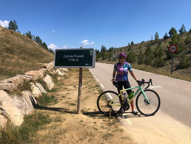
Coll de Pradell climbs 16.9 km (10.5 mi) from near Guardiola de Bergueda, in the Bergueda comarca of Catalonia, gaining 1,279 m (4,194 ft) at a 6.3% average grade to the pass at 1,730 m (5,676 ft). The numbers alone undersell it - this is one of the steepest sustained climbs anywhere in the Pyrenees, built around a single kilometer that averages 15.1%, with ramps that spike into the high teens.
The mountain this climb ascends is also part of the Fumanya paleontological area, one of Europe's largest dinosaur trackway sites, with more than 3,000 sauropod (titanosaur) footprints preserved in the exposed rock nearby. From the pass, the view opens up toward Pedraforca, Catalonia's distinctive fork-shaped peak, rising to the south.
Despite its severity, Coll de Pradell stayed mostly a local secret until the Volta a Catalunya included it for the first time in 2024, introducing it to the professional peloton. It's also a signature test in the Bergueda area's "La Ruta Minera" granfondo, a 154 km route with roughly 3,800 m of climbing.
PLAN YOUR ROUTE
 We've partnered with Sherpa-Map.com to bring you the best route planning tool. With a PRO Membership you can use this climb as a reference when creating your route.
 Coll de Pradell averages 6.3% over 16.9 km (10.5 mi), gaining 1,279 m (4,194 ft) to the pass at 1,730 m (5,676 ft). The climb's defining feature is its steepest kilometer, which averages 15.1% - one of the hardest sustained kilometers anywhere in the Pyrenees - and the steepest 500 meters within that section average 17.1%, with the single steepest stretch reaching 19.0%. Outside of that section the lower slopes run comparatively mild, so the final third of the climb feels like an entirely different ride than the first two-thirds.
Roadway: The climb is paved the entire way on a narrow, quiet mountain road with no center stripe for most of its length. The final kilometer - the 15% test that defines this climb - is a long, straight ramp with a well-known 20% grade sign that's become something of a local landmark for Catalan riders.
Traffic: Very light. This is a rural valley road serving Guardiola de Bergueda and a handful of farms and mountain refuges rather than a through route, so traffic rarely amounts to more than the occasional local vehicle or fellow cyclist.
Parking: Park in Guardiola de Bergueda near the base of the climb, where there's ordinary street parking. The village also serves as a base for the nearby Coll de Fumanya climbs, making it a reasonable place to stay if you're tackling more than one of the area's hardest ascents in a single trip.
Provisions: Guardiola de Bergueda has a few small shops and cafes for a coffee or water refill before setting off; there's nothing along the climb itself, so carry everything you'll need for the ride.
Gear: A wide-range compact or sub-compact setup earns its keep here - the final kilometer's sustained 15.1% average, with ramps into the high teens and touching 19%, is genuinely difficult even for strong climbers.
Before heading out on any cycling adventure check out our Things to Bring on a Cycling Trip and use our interactive check list to ensure you don't forget anything.
Coll de Pradell sits in the Bergueda comarca, one of Catalonia's least-crowded and most rewarding climbing areas, anchored by the town of Berga a few kilometers north.
The mountain the climb ascends is also part of the Fumanya paleontological site - one of Europe's largest dinosaur trackways, with more than 3,000 sauropod footprints preserved in the rock nearby - worth a stop before or after the ride.
The climb debuted in the Volta a Catalunya in 2024 and is a regular feature of the Bergueda area's "La Ruta Minera" granfondo.
For a multi-day trip, the comarca has several other demanding climbs worth combining with Pradell, including Coll de Pal from the medieval village of Baga to the west - see our Routes in the Area tool for other nearby climbs worth building into your trip.
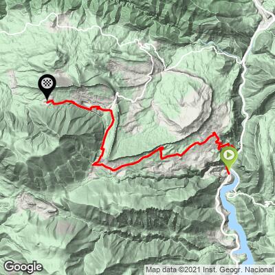
ROUTE MAP
MEMBER RATING
CURRENT WEATHER
PJAMM TRIPS ADVENTURE STARTER BUNDLES
Check out PJAMM Adventure's prepackaged (self-guided) cycling trips. They will help you plan, document and conquer your next adventure.
NEARBY CLIMBS (0) RADIAL PROXIMITY
FROM No Climbs Found
MEMBER REVIEWS & COMMENTS
Let us know what you thought of this climb. Signup for our FREE membership to write a review or post a comment.
Already have an account?
LOG IN HERE
