
17.1
PDI
13 mi
DISTANCE
3,479 ft
GAINED
4.5 %
AVG. GRADE
FULL CLIMB STATS
INTRO
PLAN YOUR ROUTE
 We've partnered with Sherpa-Map.com to bring you the best route planning tool. With a PRO Membership you can use this climb as a reference when creating your route.
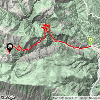
La Guàrdia d'Ares climbs 20.9 km (13.0 mi) from 620 m (2035 ft) in Noves de Segre to 1562 m (5125 ft), averaging 4.5% with 1060 m (3479 ft) of total climbing.
0 to 3 km: About 4.4%, a gentle start out of Noves de Segre.
3 to 6 km: Around 5%, with kilometers of 6 to 7%.
6 to 7 km: Almost flat - a breather.
7 to 13 km: The longest steady block, about 5.5% through Espaén.
13 to 17 km: Easier, around 3.5%, including a nearly flat kilometer.
17 to 20 km: The last real effort, close to 6% with one kilometer around 7%.
20 to 20.9 km: Gentle again into the village.
The steepest kilometer averages 7.7% and the steepest 2 km 7.2%; the steepest 0.5 km reaches 11.2%.
Roadway: Asphalt right up into the village on a narrow mountain road with a painted center line for much of its length and guardrails along the drops. Only the optional ramp from the end of the road up to the church is concrete. Under the cliffs, keep an eye out for fallen stones after storms.
Traffic: Very light. With so few people living up the valley, most of what you'll meet is the odd resident, a farm vehicle or a forestry truck. The C-14 at the bottom is the busy road - you only touch it if you ride in from La Seu d'Urgell or Organyà.
Parking: Park in Noves de Segre near the junction where the climb starts, by the signpost for La Guàrdia d'Ares and Taús. It's a tiny village with no formal car park, so leave room for tractors. If you're staying in La Seu d'Urgell, you can ride down the Segre valley to the start instead.
Gear: A standard compact with a 28 or 30 at the back is plenty - the challenge here is length, not gradient. Pace it like a long Pyrenean col. Bring a layer for the descent, since the finish is over 1500 m and the valley floor can be much warmer.
Provisions: Don't plan on buying anything on the way up; the villages along the road are tiny. Fill your bottles and pockets in La Seu d'Urgell or Organyà before you come. On a hot summer day in the Segre valley, two full bottles is the minimum for a ride this long.
Before heading out on any cycling adventure check out our Things to Bring on a Cycling Trip and use our interactive check list to ensure you don't forget anything.
La Seu d'Urgell, a short drive up the Segre valley, is the natural base, with plenty of places to stay and eat, and Andorra is just beyond it. Noves de Segre has its own small Romanesque church, Sant Sadurní.
Our Super Junyent climb starts from the same junction in Noves de Segre and splits off toward the village of Junyent, so the two make a good pair for a day in the valley. The Routes in the Area map on this page shows the other Alt Urgell roads around Noves de Segre if you want to link a few into one long ride.
If you still have legs at the top, the road carries on past La Guàrdia d'Ares toward Taús - the sign at the bottom puts it 4 km further on.
ROUTE MAP
MEMBER RATING
CURRENT WEATHER
PJAMM TRIPS ADVENTURE STARTER BUNDLES
Check out PJAMM Adventure's prepackaged (self-guided) cycling trips. They will help you plan, document and conquer your next adventure.
NEARBY CLIMBS (0) RADIAL PROXIMITY
FROM No Climbs Found
MEMBER REVIEWS & COMMENTS
Let us know what you thought of this climb. Signup for our FREE membership to write a review or post a comment.
Already have an account?
LOG IN HERE
