
20.2
PDI
10.3 mi
DISTANCE
3,454 ft
GAINED
6.1 %
AVG. GRADE
FULL CLIMB STATS
INTRO
PLAN YOUR ROUTE
 We've partnered with Sherpa-Map.com to bring you the best route planning tool. With a PRO Membership you can use this climb as a reference when creating your route.
The average grade is 6.1% over 16.6 km (10.3 mi), rising from 513 m (1,684 ft) to 1,527 m (5,011 ft). The steepest 0.5 km (0.3 mi) averages 10.5%, the steepest kilometer (0.6 mi) 9.4%, the steepest 5 km (3.1 mi) 7.3% and the steepest 10 km (6.2 mi) 6.9%. The hardest single pitch, about 100 yards (91 m), reaches 14.6%.
Riders report that the last 500 m (0.3 mi) to the col are steeper and rougher underfoot than what comes before, so save a little for the end and take care on the loose edges.
Roadway: The road is paved to the col - it was fully asphalted in 2007 - but the north side has aged badly. Riders report patched, worn asphalt, with large potholes on the lower section as of 2024 and better pavement higher up. The final 500 m (0.3 mi) to the summit narrow to a thin strip of asphalt with gravel on either side. Take it easy on the descent, especially on narrow tires.
Traffic: Minimal. The road runs through largely uninhabited country and mostly serves Alsamora and the few visitors heading for the summit and the paragliding launch.
Parking: The start is a rural roadside rather than a village or trailhead, so there is no dedicated lot; park considerately on a wide verge well clear of the carriageway. The summit area is small and open, with a stony paragliding launch just east of the col.
Provisions: There are no services on the climb. Alsamora, the only village along the route, is a hamlet of 13 residents, so fill your bottles before the start and carry food for the full 16.6 km (10.3 mi). Riders warn that there is little shade and that it gets very hot on sunny days.
Gear: A compact chainring and a wide-range cassette make the 6% to 10% sections far more comfortable. Pack a layer for the descent, and treat the pavement with caution: potholes and loose gravel make a rigid, careful descent line worthwhile.
Before heading out on any cycling adventure check out our Things to Bring on a Cycling Trip and use our interactive check list to ensure you don't forget anything.
Alsamora sits at 851 m (2,792 ft) on the northern slope of the Montsec d'Ares, about 4 km (2.5 mi) from the entrance to the Mont-rebei gorge, one of Catalonia's best-known gorge walks. It is a separate outing on foot, but it explains why this otherwise empty corner of the Pallars Jussà sees visitors in season.
From the col a dirt track continues to Sant Alís, the highest point of the Montsec d'Ares, and mountain bikers use the ridge for loops that start in Àger. On the Àger side of the pass, the Parc Astronòmic del Montsec stands beside the Coll d'Ares road 3.5 km (2.2 mi) from the town, with night-sky and daytime experiences and the Univers and Starlight exhibition rooms - a good reason to plan the south side as a second ride.
To see other climbs nearby, such as the Coll de Montllobar (oeste) near Tremp, try our Routes in the Area tool.
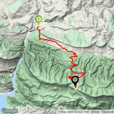
ROUTE MAP
MEMBER RATING
CURRENT WEATHER
PJAMM TRIPS ADVENTURE STARTER BUNDLES
Check out PJAMM Adventure's prepackaged (self-guided) cycling trips. They will help you plan, document and conquer your next adventure.
NEARBY CLIMBS (0) RADIAL PROXIMITY
FROM No Climbs Found
MEMBER REVIEWS & COMMENTS
Let us know what you thought of this climb. Signup for our FREE membership to write a review or post a comment.
Already have an account?
LOG IN HERE
