

15.7
PDI
4.2 mi
DISTANCE
2,014 ft
GAINED
9.2 %
AVG. GRADE
FULL CLIMB STATS
INTRO
This is the back door to Vorder Höhi, and it feels like one. From the Thur valley at Starkenbach a single-lane concrete road, grooved across its width so the bike buzzes the whole way up, climbs into the forest and stays there. There are no lake views on this side and hardly any cars - a sign at the bottom keeps cars and motorbikes off - just trees, the next bend and the sound of your own breathing.
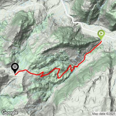
It's 6.7 km (4.2 mi) at 9.2%, gaining 614 m (2014 ft) from 909 m to the pass at 1523 m. The first two kilometers, at 8.7% and 7.5%, are as easy as it gets. After that it's four kilometers in a row between 9.4% and 11.6%, the hardest from km 4 to 5, and it only eases, to about 6%, for the final stretch onto the alp on top. From the pass the view finally arrives: the Glarus Alps, the Churfirsten and the Alpstein all around you.
Our contributor Helmuth Dekkers rode the steep Amden side up and came down this one, and his verdict was that it looks and feels steeper than its average - narrow, rough, with tight hairpins that had his disc brakes screaming. Ridden uphill that roughness just means a shaky ride, but keep it in mind if you're descending. Most riders use it as half of a loop over the pass: up from Weesen on our Vorder Hohi page and down here, or the other way round.
PLAN YOUR ROUTE
 We've partnered with Sherpa-Map.com to bring you the best route planning tool. With a PRO Membership you can use this climb as a reference when creating your route.
Overall: 6.7 km (4.2 mi) with 614 m (2014 ft) of climbing at a 9.2% average, from 909 m (2982 ft) to 1523 m (4997 ft).
Km 0-2: 8.7%, then 7.5% - the gentlest part of the climb.
Km 2-6: 10.5%, 9.4%, 11.6% and 9.4% through the forest, with very little let-up.
Km 6-6.7: about 6% to the pass.
Steepest sections: 500 m at 12%, 1 km at 11.6%, 2 km at 10.6%, 5 km at 9.8%.
Roadway: Paved, but mostly concrete rather than asphalt: a single-lane road with fine ridges across the surface that make for a buzzy, shaky ride, a little worn and uneven in places. A road bike is fine, and wider tires at lower pressure help a lot. The descent is the harder job - steep, narrow and twisting - so take it slowly. Treat this as a late-spring-to-autumn ride; in winter the pass is snow country, with a groomed winter walking trail up from the Amden side.
Traffic: Next to none. Cars and motorbikes are signed off the lane at the bottom, and the road over the top from Amden needs a permit to drive, so you'll mostly share it with farm vehicles, walkers and cows.
Parking: There's a small gravel car park right at the turnoff in Starkenbach. The village also has a bus stop on the Toggenburg valley road, a few hundred meters east.
Gear: Four straight kilometers between 9.4% and 11.6% call for a compact with a 32 or 34 at the back. Wider tires take the edge off the ridged concrete, and fresh brake pads are worth having if you're coming back down this side.
Provisions: Fill your bottles and eat in Starkenbach, which has a couple of places on the valley road. Most of the climb is shaded by forest, and a farm near the top has had water for passing riders, but don't count on it. The Alpwirtschaft Vorder Höhi at the pass is a winter restaurant, open from mid-November to around early April for the snow walkers (cash only), so in the riding season expect nothing to eat or drink at the top.
Before heading out on any cycling adventure check out our Things to Bring on a Cycling Trip and use our interactive check list to ensure you don't forget anything.
The natural ride here is a loop over the pass. Climb this side, drop through Amden to Weesen on Lake Walensee, and ride the lakeshore back - or start in Weesen, climb the harder, more scenic side on our Vorder Hohi page and come down here. Helmuth made a day of it from Walenstadt: over Vorder Höhi, down to Starkenbach, then the gentle valley road up to Wildhaus and down to Buchs in the Rhine valley, where our Buchs Malbun page climbs into Liechtenstein.
Wildhaus, a few kilometers up the valley from the start, is the birthplace of the reformer Huldrych Zwingli, and his family's wooden farmhouse is now a small museum. Around Walensee, our Tannenbodenalp and Schrina - Hochrugg Southeast pages start in Walenstadt, and the Kerenzerbergpass climbs above the south shore.
ROUTE MAP
MEMBER RATING
CURRENT WEATHER
PJAMM TRIPS ADVENTURE STARTER BUNDLES
Check out PJAMM Adventure's prepackaged (self-guided) cycling trips. They will help you plan, document and conquer your next adventure.
NEARBY CLIMBS (0) RADIAL PROXIMITY
FROM No Climbs Found
MEMBER REVIEWS & COMMENTS
Let us know what you thought of this climb. Signup for our FREE membership to write a review or post a comment.
Already have an account?
LOG IN HERE
