33.2
PDI
9.9 mi
DISTANCE
4,431 ft
GAINED
8.5 %
AVG. GRADE
FULL CLIMB STATS
INTRO
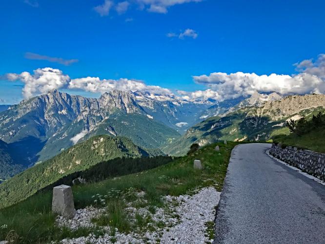
One of the most beautiful climbs we have ever had the honor to ride. We rank this the second most scenic bike climb in the world. See our World's Most Scenic Climbs page for more glorious cycling climbs!
PLAN YOUR ROUTE
Average grade is 8.5% - ride 16 kilometers gaining 1,354 meters with zero descent. 7% of the climb is at 0-5% grade, 73% is at 5-10%, and 20% is at 10-15%.
See more details and tools regarding this climb's grade via the “Profile Tool” button.
Roadway: The road is two lanes with a center broken white line for the first five kilometers and narrows to two lanes without a center line just over the bridge at kilometer 5. Soon after the bridge, the road narrows to barely two lanes. There is no shoulder on any segment of the road and the pavement is in fair to good condition - for nearly all of the last 10 kilometers the road is in very good condition.
Traffic: Minimal.
Tunnels: There are a couple tunnels, one about 100-150 meters long and so dark as to be disorienting - bring a head light and taillight.
Parking: We stayed in Bovec and road from our Hotel Mangart to the start of the climb. There are two parking spots on Log pod Mangartom on the right just across the bridge about 50 meters from the start (Map; Street View).
Provisions: There are a couple hotels where it seems you could get water in Log pod Mangartom at the start of the climb. There are no spots for food or water along the climb. The closest food and water that we know of for certain is in Bovec, 10 kilometers southwest of the start of the climb (Map).
Before heading out on any cycling adventure check out our Things to Bring on a Cycling Trip and use our interactive check list to ensure you don't forget anything.
We staid at Hotel Mangart 10 kilometers from the start of the climb. The rooms were good, the complimentary breakfast was exceptional, and we were only 10 kilometers from the climb start (Google Map + Reviews). Here are some reviews of the ride and park area where you can hike: Google Map + Reviews.
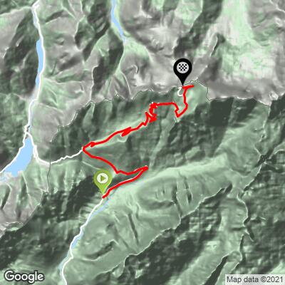
ROUTE MAP
MEMBER RATING
CURRENT WEATHER
PJAMM TRIPS ADVENTURE STARTER BUNDLES
Check out PJAMM Adventure's prepackaged (self-guided) cycling trips. They will help you plan, document and conquer your next adventure.
NEARBY CLIMBS (0) RADIAL PROXIMITY
FROM No Climbs Found
MEMBER REVIEWS & COMMENTS
Let us know what you thought of this climb. Signup for our FREE membership to write a review or post a comment.
Already have an account?
LOG IN HERE