
6.5
PDI
1.8 mi
DISTANCE
862 ft
GAINED
9.1 %
AVG. GRADE
FULL CLIMB STATS
INTRO
This 1.8 mile bike climb is located in Islas Baleares, Spain. The average gradient is 9.1% and there is a total elevation gain of 862 ft, finishing at 2,083 ft.
Use the profile tool, route map, and weather forecast to conquer this cycling climb.
Use the profile tool, route map, and weather forecast to conquer this cycling climb.
PLAN YOUR ROUTE
See more details and tools regarding this climb's grade via our interactive Profile Tool.
Information Not Available
If you have any information regarding this climb, we'd like to hear from you. Click the CONTRIBUTE button to share your thoughts with us.
Information Not Available
If you have any information regarding this climb, we'd like to hear from you. Click the CONTRIBUTE button to share your thoughts with us.
Before heading out on any cycling adventure check out our Things to Bring on a Cycling Trip and use our interactive check list to ensure you don't forget anything.
Information Not Available
If you have any information regarding this climb, we'd like to hear from you. Click the CONTRIBUTE button to share your thoughts with us.
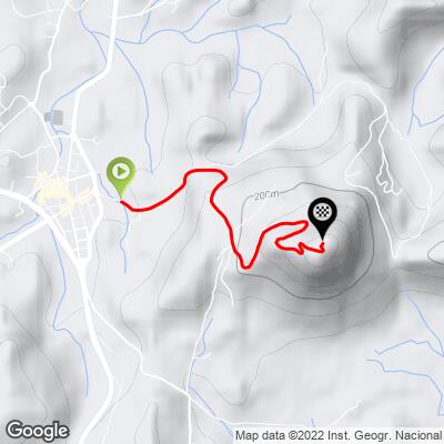
ROUTE MAP
MEMBER RATING
CURRENT WEATHER
PJAMM TRIPS ADVENTURE STARTER BUNDLES
Check out PJAMM Adventure's prepackaged (self-guided) cycling trips. They will help you plan, document and conquer your next adventure.
NEARBY CLIMBS (0) RADIAL PROXIMITY
FROM No Climbs Found
MEMBER REVIEWS & COMMENTS
Let us know what you thought of this climb. Signup for our FREE membership to write a review or post a comment.
Already have an account?
LOG IN HERE
yomanjo
Some important background/context: I rode this in September, 2022 on a sunny day in the mid 80's F (or low 30's C). Did not look at GPS map on my computer or Garmin before attempting (which was a mistake).
To the climb: You start at fairly easy gradients in the 4-7% range and then BAM, all the sudden you're at 11%. Road "flattens" out again to around 6% and then BAM, 16%. Repeat, then 18% around a corkscrew section (great view if you have to stop, like I did).
This climb is no joke, especially on a hot, sunny day, especially when you have no idea what you're up against and don't pace yourself. Put it in the granny gear and spin up the 5-10% sections so you have enough in the tank to power up the 15% ramps.
According to Ride With GPS, this is 1.9 miles with a max grade of 18.6%. In my experience, you'll see >15% on your bike computer 3 separate times, and at that grade, another % or three of gradient makes a noticeable difference imo.