
20.8
PDI
8.9 mi
DISTANCE
3,184 ft
GAINED
6.8 %
AVG. GRADE
FULL CLIMB STATS
Page Contributor(s): Erwan Treguier, France
INTRO
PLAN YOUR ROUTE
 We've partnered with Sherpa-Map.com to bring you the best route planning tool. With a PRO Membership you can use this climb as a reference when creating your route.
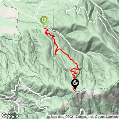
The Cime de Coma Morera route forestière averages 6.8% over 14.3 km (8.9 mi), climbing 970 m (3,184 ft) from 1237 m (4,057 ft) in Osséja to 2203 m (7,228 ft) at the top.
The steepest 100 yards (91 m) reach 15.5% and the steepest quarter mile (0.4 km) averages 11.3%. Over longer stretches the grade eases: the steepest kilometer (0.6 mi) averages 9.4%, the steepest mile (1.6 km) 8.9%, and the steepest 5 km (3.1 mi) 7.7%. Riders describe the road as relatively long without excessive grades, with flatter stretches that allow some recovery.
Roadway: Paved all the way to the summit, but not smooth. Riders report a degraded surface near the start by the campsite that improves after the first hairpin, grass growing down the middle of the road on long stretches, and a wild, wind-exposed top. Partway up the road forks into two branches that rejoin near the Col de Pradelles at about 2000 m (6,562 ft). At this altitude expect snow and frost on the upper road outside summer.
Traffic: Very light. This is a forestry and pasture road, and once you leave Osséja you can expect to see almost no vehicles.
Parking: Osséja is a quiet border village of roughly 1,400 residents, and riders start from the village streets, following the signs for Valcebollère and then the route forestière, which begins near the campsite. If you want a longer day, Bourg-Madame sits 3 km (1.9 mi) below at about a 4% grade and is where some riders begin the full ascent.
Weather: At 2203 m (7,228 ft) the summit is open and exposed, and strong wind is the most common complaint, so carry a windproof layer even on a warm day on the Cerdagne plateau.
Provisions: There are no services on the climb. Fill bottles and buy food in Osséja or in Bourg-Madame, 3 km (1.9 mi) below, before you start, and carry a spare tube given how few vehicles pass.
Before heading out on any cycling adventure check out our Things to Bring on a Cycling Trip and use our interactive check list to ensure you don't forget anything.
Osséja sits on the French edge of the Cerdagne, a high plateau shared with Spain, and Bourg-Madame, 3 km (1.9 mi) away, adjoins the Spanish town of Puigcerdà. Osséja also has a railway station with connections toward Latour-de-Carol and Villefranche-de-Conflent, so a car-free arrival is possible.
The signs that lead to this climb also lead to Valcebollère, where the municipal car park at 1510 m (4,954 ft) is the trailhead of the Chemin de la Retirada. This 10.7 km (6.6 mi) memorial hiking trail follows the route of Spanish refugees of the Retirada to border stone 505 at 2196 m (7,205 ft) and makes a good rest-day walk. If you want a second ride from the same village, our Cime de Coma Morera (ouest) page covers another route from Osséja.
The summit is more than 2000 m (6,562 ft) above sea level, so check conditions before you go with our Weather tool.
ROUTE MAP
MEMBER RATING
CURRENT WEATHER
PJAMM TRIPS ADVENTURE STARTER BUNDLES
Check out PJAMM Adventure's prepackaged (self-guided) cycling trips. They will help you plan, document and conquer your next adventure.
NEARBY CLIMBS (0) RADIAL PROXIMITY
FROM No Climbs Found
MEMBER REVIEWS & COMMENTS
Let us know what you thought of this climb. Signup for our FREE membership to write a review or post a comment.
Already have an account?
LOG IN HERE
