
18.4
PDI
11.5 mi
DISTANCE
3,322 ft
GAINED
5.2 %
AVG. GRADE
FULL CLIMB STATS
Page Contributor(s): Erwan Treguier, France
INTRO
PLAN YOUR ROUTE
 We've partnered with Sherpa-Map.com to bring you the best route planning tool. With a PRO Membership you can use this climb as a reference when creating your route.
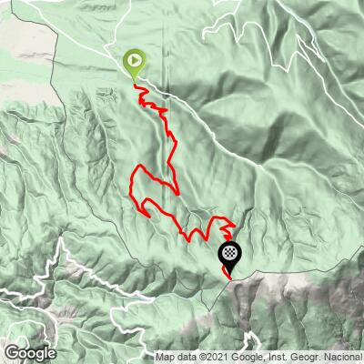
The west road to the Cime de Coma Morera averages 5.2% over 18.6 km (11.5 mi), gaining 1013 m (3322 ft) from 1237 m (4057 ft) in Osséja to 2203 m (7228 ft) at the border, with about 46 m (150 ft) of descending along the way.
The steepest 91 m (100 yd) reaches 14.7% and the steepest 0.5 km (0.3 mi) 10.9%. The steepest kilometer (0.6 mi) averages 9.4%, the steepest 2 km (1.2 mi) 8.2% and the steepest 5 km (3.1 mi) 7.7%, while the steepest 10 km (6.2 mi) averages just 5.6%.
The first 6 km (3.7 mi) to the fork is the hardest sustained section, about 7.2%. The next 3 km (1.9 mi) is close to flat, with a short dip. From there the road climbs at 6 to 7% for about 3 km (1.9 mi), eases again before the Col de Pradelles, and finishes with about 3.5 km (2.2 mi) at roughly 6% to the summit.
Roadway: Paved to the summit, but this is a forestry and pasture road, not a maintained highway. The surface is broken near the start by the campsite, improves after the first hairpin, and is patchy higher up, with potholes, loose stones and grass growing down the middle on long stretches of the western branch. The climbing is manageable on a road bike, but take the descent slowly. At this altitude, expect snow and frost on the upper road outside summer.
Traffic: Very light. Once you leave Osséja you may not see a single car, and one rider on the western branch in 2021 met neither a vehicle nor another cyclist the whole way up.
Parking: There is no trailhead car park at the bottom, so start from Osséja itself, a small village where you can park considerately in the streets near the center (the tourist office on Place Sainte-Lucie can point you to current options). The road ends at a fenced parking area on the frontier at the summit.
Gear: Standard road gearing works on this side, since the steepest kilometer averages 9.4%, but wider tires are a real advantage on the rough, patched surface. The summit is open and exposed at 2203 m (7228 ft) and is often very windy, so carry a windproof layer.
Provisions: There are no services after Osséja. Fill bottles and carry food from the village, and pack a spare tube and tools, since punctures on the descent are a common complaint and passing help is rare. There are several benches along the route, including one at the Col de Pradelles that makes a good picnic stop.
Before heading out on any cycling adventure check out our Things to Bring on a Cycling Trip and use our interactive check list to ensure you don't forget anything.
Osséja (Oceja in Catalan) is a small border village in French Catalonia, inside the Pyrénées Catalanes Regional Natural Park, and it holds France's Station Verte label for rural tourism. Our Cime de Coma Morera (route forestière) page covers getting here by train and the Chemin de la Retirada walk from nearby Valcebollère, so this page sticks to the other side of the valley.
The village has its own small lake, the Lac d'Osséja, and a three-star campsite, Camping El Paillès, if you want to base yourself here. The Cerdagne plateau itself is a high, sunny basin shared with Spain, and it is a fine place to string climbs together: the Puigmal ski road, Err and the Collada de Toses on the Catalan side are all within a short ride.
See other climbs nearby, or build a custom route from here, with our Routes in the Area tool.
ROUTE MAP
MEMBER RATING
CURRENT WEATHER
PJAMM TRIPS ADVENTURE STARTER BUNDLES
Check out PJAMM Adventure's prepackaged (self-guided) cycling trips. They will help you plan, document and conquer your next adventure.
NEARBY CLIMBS (0) RADIAL PROXIMITY
FROM No Climbs Found
MEMBER REVIEWS & COMMENTS
Let us know what you thought of this climb. Signup for our FREE membership to write a review or post a comment.
Already have an account?
LOG IN HERE
