3.9
PDI
2.8 mi
DISTANCE
775 ft
GAINED
5.2 %
AVG. GRADE
FULL CLIMB STATS
INTRO
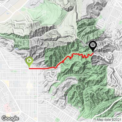
This 2.8 mile bike climb is located in CA, USA. The average gradient is 5.2% and there is a total elevation gain of 775 ft, finishing at 1,161 ft.
Use the profile tool, route map, and weather forecast to conquer this cycling climb.
Use the profile tool, route map, and weather forecast to conquer this cycling climb.
PLAN YOUR ROUTE
This climb averages 0%. The steepest quarter mile of this climb is 0%. NaN miles of the climb is at or above 10% grade. The gradient on this climb is broken down as follows:
See more details and tools regarding this climb's grade via our interactive Profile Tool.
See more details and tools regarding this climb's grade via our interactive Profile Tool.
Roadway and Traffic:
Road surface is good as of February 2021; traffic is light.
Parking:
There is a public parking space in the Hacienda Hills near the top of the climb - we recommend starting from there and doing several close roads in your ride, including Oak Canyon Dr
Information Not Available
If you have any information regarding this climb, we'd like to hear from you. Click the CONTRIBUTE button to share your thoughts with us.
Before heading out on any cycling adventure check out our Things to Bring on a Cycling Trip and use our interactive check list to ensure you don't forget anything.
Turnbull Canyon and the Hacienda hills have good hiking and mountain biking trails for being in urban Los Angeles.
ROUTE MAP
MEMBER RATING
CURRENT WEATHER
PJAMM TRIPS ADVENTURE STARTER BUNDLES
Check out PJAMM Adventure's prepackaged (self-guided) cycling trips. They will help you plan, document and conquer your next adventure.
NEARBY CLIMBS (0) RADIAL PROXIMITY
FROM No Climbs Found
MEMBER REVIEWS & COMMENTS
Let us know what you thought of this climb. Signup for our FREE membership to write a review or post a comment.
Already have an account?
LOG IN HERE
JonLested

Modest climb from East Whittier into Hacienda Heights. Roadway is two-lanes with little to no shoulder. Road has patches of gravel/sand/dirt from the canyon wall on your right. Lots of hairpins and blind corners so be wary of vehicle traffic in both directions. Nice views of the canyon to the left as you ascend and the homes on the crest give you a good sense where the finish is at.