
29.9
PDI
7.5 mi
DISTANCE
3,715 ft
GAINED
9.4 %
AVG. GRADE
FULL CLIMB STATS
INTRO
PLAN YOUR ROUTE
 We've partnered with Sherpa-Map.com to bring you the best route planning tool. With a PRO Membership you can use this climb as a reference when creating your route.
 The average grade is 9.4% over 7.5 miles, gaining 3,715 feet to a summit at 6,062 feet. The steepest kilometer comes late in the climb, beginning around km 9.5 (mile 5.9) and averaging roughly 11.2% - there's no flat or downhill relief anywhere on the route, so pacing from the base matters as much as leg strength for the final push.
Roadway: The road climbing out of Ilanz through Sevgein to Riein and beyond is paved essentially the entire way; multiple rider reports place the only unpaved section in the final couple hundred meters near the very top, easily manageable on a standard road bike.
Traffic: Traffic is light out of Ilanz and through Sevgein, and drops further above Riein, where vehicle access is restricted for the final stretch to the summit - Google's own Street View car stops around mile 3.9 for the same reason. Expect the occasional local or farm vehicle on the lower half and essentially nothing above it.
Parking: Ilanz is a small, walkable town, and the climb starts right at its eastern edge on Ilanzerstrasse. Street parking is available near the old town center, a short ride from the start of the climb.
Provisions: There are no services above Ilanz on this climb, so fuel up in town before you start - the historic old town has cafes and small shops near the center.
Gear: A standard road bike handles this climb without issue for nearly its full length. If you plan to ride all the way to the true summit, slightly wider tires make the short unpaved stretch near the top more comfortable, though it isn't required if you turn around where the pavement ends.
Before heading out on any cycling adventure check out our Things to Bring on a Cycling Trip and use our interactive check list to ensure you don't forget anything.
Ilanz makes an easy, walkable base for this climb, with a compact old town at the foot of the route and easy access to the wider Surselva valley, which is dense with similarly steep, quiet climbs - Alpe de Siat, a short drive away near Rueun, is one of several worth combining with a stay here. See what else is within reach of this climb's start with our Routes in the Area tool.
Because the final stretch near the summit narrows and turns unpaved, decide before you leave whether you're aiming for the true top or treating the point where the pavement ends as your natural turnaround.
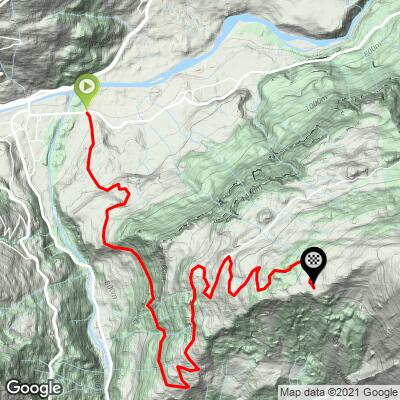
ROUTE MAP
MEMBER RATING
CURRENT WEATHER
PJAMM TRIPS ADVENTURE STARTER BUNDLES
Check out PJAMM Adventure's prepackaged (self-guided) cycling trips. They will help you plan, document and conquer your next adventure.
NEARBY CLIMBS (0) RADIAL PROXIMITY
FROM No Climbs Found
MEMBER REVIEWS & COMMENTS
Let us know what you thought of this climb. Signup for our FREE membership to write a review or post a comment.
Already have an account?
LOG IN HERE
