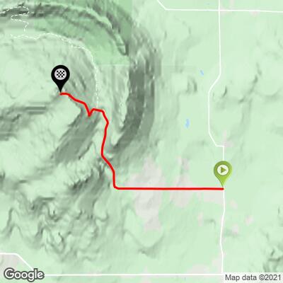
Mont Megantic Bike Climb - PJAMM Cycling

11.7
PDI
5.9 mi
DISTANCE
1,991 ft
GAINED
6.4 %
AVG. GRADE

FULL CLIMB STATS

Page Contributor(s): Lynn Sugden, Sherwood Park, AB

INTRO

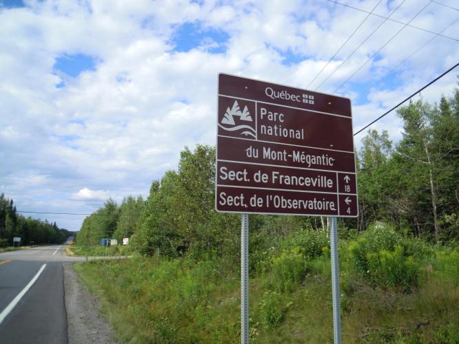
This is a challenging climb in southern Quebec (just 15 kilometers north of the US border with Maine and Vermont).  The climb ends at Mont Megantic Observatory.
This climb has a 6.5% average (7.5% climb only).   41% of the climb is at 0-5% grade, 19% is at 5-10%, and 30% is at 10-15%.  The steepest 500 meters are14.8%.

See more details and tools regarding this climb's grade via the “Profile Tool” button.
Roadway:  Riding north from the town of Nortre-Dame-des-Bois (Our Lady of the Forest) on Route du Parc, the road surface is pavement in good condition with a small shoulder. Then turn west (continuing on Route du Parc), which is the beginning of the climb, continues on pavement in good condition with a small shoulder. Once past the gate to Parc national du Mont-Mégantic the shoulder disappears. The pavement remains in good condition to within 100 to 200 meters of the summit where the path is gravel to the observatory. The traffic is low from the town site to the gates and very low after the gates.   

Traffic:  Mild.

Parking:  There is a bit of parking across Route 51 on the side of the road (MapStreet View). 
Provisions:  None on the climb. The closest food and beverages are in Notre-Dame-des-Bois, three kilometers south of climb start (Map). 
Before heading out on any cycling adventure check out our Things to Bring on a Cycling Trip and use our interactive check list to ensure you don't forget anything.
Visit the Mont Megantic Observatory and also the Astrolab - Home Page (hours; note - reservations required for the Astrolab).  The Astrolab is at km 2.5 and the observatory is at the finish of the climb. 

ROUTE MAP

MEMBER RATING

Difficulty: Strenuous
4
Road
5
Traffic
4
Scenery

CURRENT WEATHER

PJAMM TRIPS ADVENTURE STARTER BUNDLES

Check out PJAMM Adventure's prepackaged (self-guided) cycling trips. They will help you plan, document and conquer your next adventure.
ALL TRIPS
Browse all of our prepackaged trips and find your next adventure!

NEARBY CLIMBS (0) RADIAL PROXIMITY

FROM
No Climbs Found

MEMBER REVIEWS & COMMENTS

Let us know what you thought of this climb. Signup for our FREE membership to write a review or post a comment.
Already have an account?

Jul 17, 2023
difficulty: Strenuous
scenery: 4
traffic: 5
road: 4
Jul 17, 2023
scenery: 4
traffic: 5
road: 4
You should exclude the first 4 km from this post, as its not part of the climb really. Youll start once you pay the park access fee (about 10$ CND in 2023), and it starts at about 10% out of the gate. The difficult part is once you hit the 14-16% part after the first km or so. Didnt have an appropriate casette so did a bit of sverving.
ROUTE MAP
PROFILE TOOL
Route Data
S.G. (%)
hide
Segment Data
hide

Climb Profile Not Found
CLIMB SUMMARY

Cyclingt Mont-Mégantic, the highest paved road in Quebec

Ride 9.4 kilometers gaining 614 meters at 6.5% average grade.

This is a challenging climb in southern Quebec (just 15 kilometers north of the US border (Maine and Vermont).

True statement!

There is a ½ kilometer segment that averages 14.5%

Our good Canadian friend and contributor  Lynn Sugden writes:  In answer to "do you also consider this the hardest climb in Quebec?" the answer is yes when considering it is recognized by the UCI and has a reputation based on the pros that have won during the Tour de Beauce.  My personal experience leads me to 4 kilometers from hell approximately 100 kms NE of Québec City.  It is a climb on the Route du Lac Trois Saumons passing by the SW tip of Lac Trois Saumons. There are a couple of ramps greater than 20%.  (I had to twice do a circle to build up enough speed to continue up the hill.  But, I did not get off my bike!  As stupid as that is for an old man.)  The hill starts at 47.124188 : -70.2304533 and ends at 47.1079841 : -70.2170406 .  Unfortunately, I don't have any photos of the climb.  When you are up to your arse in alligators (viz climbing +20%), you forget that you were supposed to drain the swamp (viz take photos).  I can clip the gpx file for this climb from the day's ride if you want it.  Bye the bye the ride in the St Lawrence River valley before and after the climb is excellent.

Climb ends at Mont-Mégantic Observatory

Photo:  Jean-Pierre Guillet

Mont-Mégantic is commonly included in the Tour de Beauce (a professional 5 day stage race held each June in the Beauce region of Quebec).  The race has been held each year since 1986 with Levi Leipheimer being the most notable champion (1998; his 1999 victory was stricken).

Canada’s Matteo Dal-Cin's summit victory on Mont-Mégantic

 Stage 2 of the 32nd Tour de Beauce

Photo:  Cyclingnews.com