
17.2
PDI
6.4 mi
DISTANCE
2,589 ft
GAINED
7.7 %
AVG. GRADE
FULL CLIMB STATS
INTRO
This is the short, steep way up to Passo dei Casoni. Where the Martinello side takes 16 km to get there, the road from Rocchetta di Vara does it in 10.3 km (6.4 mi), gaining 789 m (2589 ft) at 7.7% - and it saves the nastiest bit for the very end, a final ramp of around 15% onto the pass.
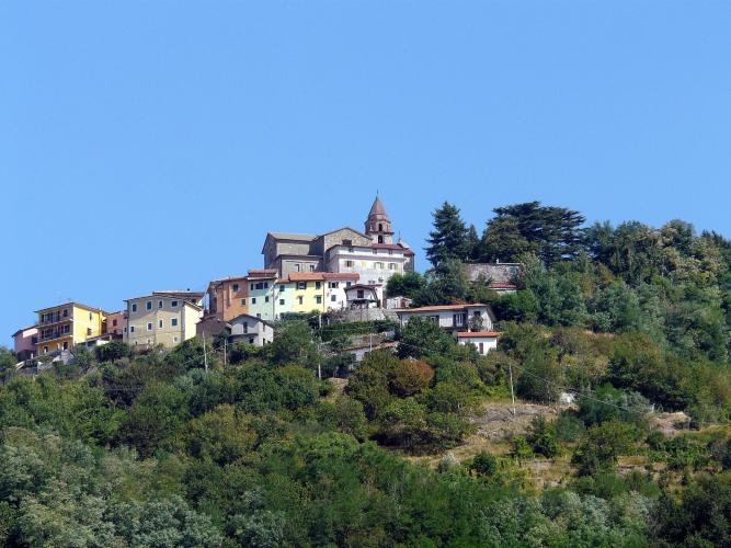
Rocchetta is a small village at about 220 m in the upper Val di Vara. The road climbs out of it at 6.4 to 9% for the first 4 km, with the steepest kilometer just over 10%, and from the bottom you can see Suvero high above you: a hill village with its castle and the church of San Giovanni Battista lined up along the ridge. You reach it around km 6, at 687 m. Above Suvero the grade settles back to 6 to 7% through the pinewoods the village is known for, the trees closing in and the air cooler, until the last kilometer steepens to 8.5% and the final few hundred meters kick up hard to the top at 994 m.
The pass sits on the Alta Via dei Monti Liguri, Liguria's long ridge-top trail, so expect hikers rather than cars at the top; our Passo dei Casoni (Martinello) page covers the pass itself. Go back the way you came or descend the long way to Martinello - the road over the top toward Arpiola in Lunigiana has been landslide-damaged for years and isn't suited to road bikes.
PLAN YOUR ROUTE
 We've partnered with Sherpa-Map.com to bring you the best route planning tool. With a PRO Membership you can use this climb as a reference when creating your route.
It's 10.3 km (6.4 mi) from 205 m (673 ft) in Rocchetta di Vara to 994 m (3262 ft) at the pass, a gain of 789 m (2589 ft) at an average of 7.7%. The steepest kilometer averages 10.2%, the steepest 2 km 8.8% and the steepest 5 km 8.2%.
Km 0-5: The steepest stretch of sustained climbing: 6.4%, 8.0%, 8.3%, 9.0% and 7.6%.
Km 5-9: Through Suvero and into the pines at 5.9 to 7.8%.
Km 9-10.3: 7.2%, then 8.5%, and a final 200 m or so at about 15% to the pass.
Roadway: Asphalt to the top on a narrow mountain road, with Google Street View imagery from October and November 2024 along its whole length. Expect tight bends and blind corners, and leaves or pine needles under the trees. If you're thinking of descending the other side to Martinello, the SP8 below Calice al Cornoviglio has been hit by landslides: it reopened round the clock in August 2025, but the Province of La Spezia still closes it during weather alerts while slope works continue. The road down the far side toward Arpiola is not suitable for road bikes.
Traffic: Light. The road serves Suvero and a few smaller hamlets, so most of what you'll meet is local traffic, and above Suvero there's very little at all.
Parking: Rocchetta di Vara is a small village, so park where signs allow and keep clear of driveways. Brugnato, about 5 km away in the main valley, has more space and makes a good base to ride from.
Gear: The final ramp near 15% is short but real, and the first 5 km average more than 8%; low gears - think 34-32 - will save your legs for that last pitch. In summer the lower slopes get hot; the pines above Suvero help.
Provisions: Fill bottles and buy food in Rocchetta or Brugnato before you start. Suvero is the only village of any size on the way up and the pass has nothing, so carry what you'll need.
Before heading out on any cycling adventure check out our Things to Bring on a Cycling Trip and use our interactive check list to ensure you don't forget anything.
The Val di Vara calls itself the organic valley (valle del biologico), for its woods, meadows and small farms. Brugnato is the hub: a medieval village built in a ring, known for its flower carpets at Corpus Domini in June and its canestrelli biscuits. Further up the valley, Varese Ligure has an unusual round medieval village of its own.
Rocchetta and Brugnato start a cluster of Val di Vara climbs: Passo del Rastrello (Fiume Vara) leaves from Brugnato, and Passo Calzavitello and Cornice are just up the valley. The Cinque Terre coast is less than an hour's drive away if someone in your group wants a day by the sea.
ROUTE MAP

MEMBER RATING
CURRENT WEATHER
PJAMM TRIPS ADVENTURE STARTER BUNDLES
Check out PJAMM Adventure's prepackaged (self-guided) cycling trips. They will help you plan, document and conquer your next adventure.
NEARBY CLIMBS (0) RADIAL PROXIMITY
FROM No Climbs Found
MEMBER REVIEWS & COMMENTS
Let us know what you thought of this climb. Signup for our FREE membership to write a review or post a comment.
Already have an account?
LOG IN HERE
