
18.2
PDI
10.1 mi
DISTANCE
3,285 ft
GAINED
5.8 %
AVG. GRADE
FULL CLIMB STATS
INTRO
PLAN YOUR ROUTE
 We've partnered with Sherpa-Map.com to bring you the best route planning tool. With a PRO Membership you can use this climb as a reference when creating your route.
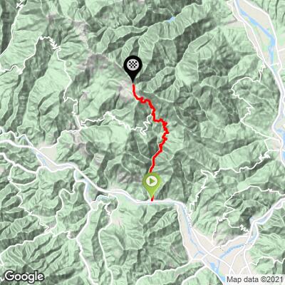
Passo dei Casoni from Martinello climbs 16.2 km (10.1 mi) and 1001 m (3285 ft) at a 5.8% average, with about 66 m (218 ft) of descending along the way.
0-5 km (0-3.1 mi): A gentle start at about 4%, including a nearly flat kilometer near Usurana.
5-6 km (3.1-3.7 mi): The first steep pitch, 10.0%, up to Calice al Cornoviglio.
6-11 km (3.7-6.8 mi): Easy, mostly 3-5%, through Calice and on to Villagrossa.
11-15 km (6.8-9.3 mi): The crux: about 400 m (1312 ft) of gain at an average of 10.0%, with three kilometers at 11% or more. The steepest kilometer averages 14.0%, and the steepest 500 m (0.3 mi) 15.8%.
15-16.2 km (9.3-10.1 mi): Easing to 2-4% for the run in to the pass.
Roadway: The route follows narrow, winding provincial roads up from the Vara valley - first to Calice al Cornoviglio, then on the SP6 and SP32 to the pass - paved throughout, with blind bends that call for care on the descent. The lower section has a difficult recent history: in May 2024 a landslide closed the SP8 between Usurana and Calice, and through 2025 the Province of La Spezia was still installing rockfall barriers and stabilizing the slope at Ferdana. Check current status with the Province of La Spezia or the Comune di Calice al Cornoviglio before riding. Over the top, the road down toward Arpiola in Lunigiana has been damaged by landslides since 2011 and is not suitable for road bikes, so plan to return the way you came or descend toward Rocchetta di Vara.
Traffic: Light. These are rural roads serving scattered hamlets, with little through traffic, so expect mainly local cars, most of them around Calice.
Parking: Martinello and Piano di Madrignano sit on the Vara valley floor beside the main valley road. Park in the villages where signs allow and keep driveways and farm access clear. If you only want the steep upper half, Calice al Cornoviglio, about 6 km (3.7 mi) up, makes a good alternative start.
Gear: The first half is gentle, but the 4 km (2.5 mi) at 10% near the top, with ramps near 16%, call for low gears - a compact crankset with a 32 or 34 tooth largest cog is a good idea. You start barely above sea level and finish nearly 1000 m (3281 ft) higher on an exposed ridge, so outside of summer carry a layer for the descent.
Provisions: Stock up in the valley before you start. Calice al Cornoviglio is the only village of any size on the route, so carry enough water for the long upper half.
Before heading out on any cycling adventure check out our Things to Bring on a Cycling Trip and use our interactive check list to ensure you don't forget anything.
Calice al Cornoviglio is the highlight along the way. Its castle, founded in the 11th century and later held by the Malaspina, the Fieschi and, from 1547, the Doria, dominates the medieval village. It is now owned by the municipality and houses a beekeeping museum, the David Beghè art gallery, the small Pietro Rosa museum and the Val di Vara Brigade Museum, as well as an environmental education center for the Montemarcello-Magra Regional Natural Park.
At the top, the pass is where two stages of the Alta Via dei Monti Liguri meet - one arriving from Passo del Rastrello, the other leaving for Passo Alpicella - so you'll often see hikers here. The ridge around Monte Cornoviglio looks out over the Apuan Alps and the Gulf of Poets.
The other side of this pass, from Rocchetta di Vara, and many more Val di Vara climbs such as Passo del Rastrello start nearby, so see other climbs nearby, or build a custom route from here, with our Routes in the Area tool.
ROUTE MAP
MEMBER RATING
CURRENT WEATHER
PJAMM TRIPS ADVENTURE STARTER BUNDLES
Check out PJAMM Adventure's prepackaged (self-guided) cycling trips. They will help you plan, document and conquer your next adventure.
NEARBY CLIMBS (0) RADIAL PROXIMITY
FROM No Climbs Found
MEMBER REVIEWS & COMMENTS
Let us know what you thought of this climb. Signup for our FREE membership to write a review or post a comment.
Already have an account?
LOG IN HERE
