
16.9
PDI
10.2 mi
DISTANCE
3,158 ft
GAINED
5.5 %
AVG. GRADE
FULL CLIMB STATS
INTRO
PLAN YOUR ROUTE
 We've partnered with Sherpa-Map.com to bring you the best route planning tool. With a PRO Membership you can use this climb as a reference when creating your route.
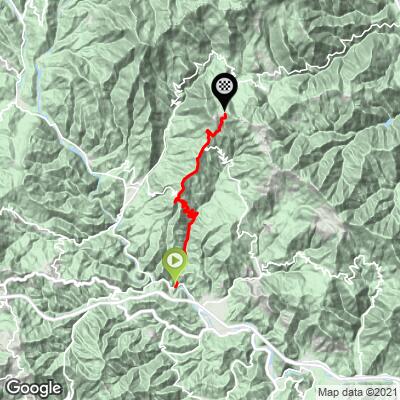
From 144 m (472 ft) at Bozzolo to 1042 m (3419 ft) at the pass, the climb gains 963 m (3158 ft) over 16.4 km (10.2 mi) at an average of 5.5%. The steepest kilometer averages 9.8%, the steepest half kilometer 11.9%, the steepest 2 km 9.3% and the steepest 5 km 8.3%.
Km 0-4: 2.1% along the valley floor, with a short dip around km 2.
Km 4-9.6: 7.4% through Scogna Inferiore to Scogna Superiore - the hardest part of the climb.
Km 9.6-12.4: 5.6% on the SP5.
Km 12.4-13.2: 3.1%, the only real rest.
Km 13.2-16.4: 6.8% up the open ridge to the pass.
Roadway: Paved throughout. The first few kilometers are a narrow, worn lane with gravel along the edges, and the climb up through the Scogna hamlets is single-lane and patchy too, with leaves and grit under the trees in autumn. Higher up, the SP5 is a proper two-lane road with markings, though the last stretch to the pass has potholed and patched sections.
Traffic: Light. The lower lanes serve a few hamlets, and the SP5 is a minor link between the Val di Vara and the Zeri valley. Watch for cattle on the open road near the top.
Parking: Bozzolo is a small roadside hamlet, so don't count on more than a verge. Brugnato, about 2 km away and right by the Brugnato exit of the A12, has far more room, so most riders driving in will start there and add the flat 2 km.
Gear: Compact gearing with a 30 or 32 at the back takes the sting out of the steep kilometers above Scogna Inferiore. The top is open and exposed, so carry a wind jacket for the descent.
Provisions: Buy food and fill bottles in Brugnato before you start. The route passes only small hamlets, so carry what you'll need.
Before heading out on any cycling adventure check out our Things to Bring on a Cycling Trip and use our interactive check list to ensure you don't forget anything.
Brugnato is the base for this side, and our Passo dei Casoni (Rocchetta di Vara) page covers the village itself. What this climb adds is the far side of the pass: the Zeri valley in Tuscany's Lunigiana, home to the Zeri lamb, an old local breed protected as a Slow Food presidium - worth looking for on a menu if you descend that way. Below the pass on the Zeri side are the villages of Castello and Bergugliara, with the ruins of the old castle of Zeri.
The Rastrello has other approaches on our site, including Sesta Godano and Valgiuncata, and Passo Calzavitello starts just up the valley. The Cinque Terre coast is less than an hour's drive away for a rest day.
ROUTE MAP
MEMBER RATING
CURRENT WEATHER
PJAMM TRIPS ADVENTURE STARTER BUNDLES
Check out PJAMM Adventure's prepackaged (self-guided) cycling trips. They will help you plan, document and conquer your next adventure.
NEARBY CLIMBS (0) RADIAL PROXIMITY
FROM No Climbs Found
MEMBER REVIEWS & COMMENTS
Let us know what you thought of this climb. Signup for our FREE membership to write a review or post a comment.
Already have an account?
LOG IN HERE
