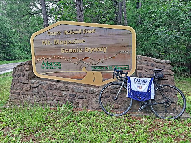
Magazine Mountain (South) Bike Climb - PJAMM Cycling

3.1
FIETS
8 mi
DISTANCE
2,089 ft
GAINED
4.9 %
AVG. GRADE

FULL CLIMB STATS

Page Contributor(s): Bernard Cerles, USA; Dan Razum, San Jose, California

INTRO

This 8 mile bike climb is located in AR, USA. The average gradient is 4.9% and there is a total elevation gain of 2,089 ft, finishing at 2,523 ft.

Use the profile tool, route map, and weather forecast to conquer this cycling climb.

See more details and tools regarding this climb's grade via our interactive Profile Tool.
Information Not Available

If you have any information regarding this climb, we'd like to hear from you. Click the CONTRIBUTE button to share your thoughts with us.

Information Not Available

If you have any information regarding this climb, we'd like to hear from you. Click the CONTRIBUTE button to share your thoughts with us.

Before heading out on any cycling adventure check out our Things to Bring on a Cycling Trip and use our interactive check list to ensure you don't forget anything.
Information Not Available

If you have any information regarding this climb, we'd like to hear from you. Click the CONTRIBUTE button to share your thoughts with us.

ROUTE MAP

MEMBER RATING

Not Yet Rated
-
Road
-
Traffic
-
Scenery

CURRENT WEATHER

PJAMM TRIPS ADVENTURE STARTER BUNDLES

Check out PJAMM Adventure's prepackaged (self-guided) cycling trips. They will help you plan, document and conquer your next adventure.
ALL TRIPS
Browse all of our prepackaged trips and find your next adventure!

NEARBY CLIMBS (0) RADIAL PROXIMITY

FROM
No Climbs Found

MEMBER REVIEWS & COMMENTS

Let us know what you thought of this climb. Signup for our FREE membership to write a review or post a comment.
Already have an account?

Nov 16, 2021
The climb starts easily from Havana. After 3 kms, the climb gets steeper with 4 to 5 kms at 6-7% without any respite. Last kilometers are easier. After a left turn, the road reaches a 2 km loop encircling Mont Magazine which is accessible by foot. Nice lodge close to the summit. Overall, very scenic ride in the Ozark range and easy descent towards Paris.
ROUTE MAP
PROFILE TOOL
Route Data
S.G. (%)
hide
Segment Data
hide

Climb Profile Not Found
CLIMB SUMMARY

Cycling Mt. Magazine South

Ride 8 miles gaining 2,089’ at 4.9% average grade.

Mount Magazine is the highest point in Arkansas and the US Interior Highlands (includes parts of Arkansas, southern Missouri, eastern Oklahoma and southeastern Kansas).  This is one of but a few mountainous regions between the Appalachian and Rocky Mountains.  The name dates back 200 years or more to French hunters who referred to the barn as Magazine because it looked like a large barn or “magazine” where ammunition would be stored.

Climb summary by PJAMM ambassador Dan Razum, San Jose, California.  

The climb starts a little outside the town of Havana. There isn't any parking at the base of the climb, so we parked outside Havana and did a couple of miles warmup to reach the climb. The road is in decent condition, with a small shoulder in some places.  There wasn't much traffic when we rode, but it was rainy/foggy, so there might be more traffic on a nice day.

The lanes are wide, though, and it isn't a major road so we don't think traffic would really be a concern on this climb.

On the lower slopes there are lots of trees on either side of the road.  After we pass the second sharp curve, about 3/4 of the way up, the road is more exposed for a half mile or so and there might be some views.  There is a pullout that looks promising but all we could see was fog the day we were there, unfortunately.

The summit is unmarked and it isn't too obvious.  About a quarter mile after the summit is the entrance to Mt Magazine State Park and it is worthwhile to go to the Visitor Center there, they have a nice exhibit, including a 3D model of the mountain, showing the road along both sides of the mountain.

Access to full Climb Summary requires a PJAMM Cycling PRO Membership!

It takes less than a minute to sign up & with your PRO membership you can:
  • Rate climbs, post comments and share your experiences on any of our climb pages
  • Create bucket lists of climbs & mark the dates you complete them
  • Weather data for all climbs - Start & Finish
  • Upload photos to your member page to customize your PJAMM Cycling experience
  • Utilize all of our interactive tools - Profile & Routes in Area
  • Download climb route .gpx files
LEARN MORE
SIGN UP

Already have an account? LOG IN HERE