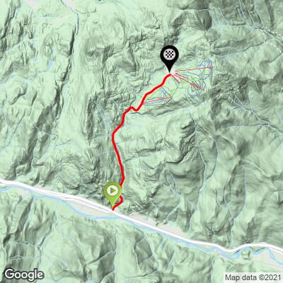
12.6
PDI
4.2 mi
DISTANCE
1,826 ft
GAINED
8.1 %
AVG. GRADE
FULL CLIMB STATS
INTRO
Don’t let the 8% fool you! While 8% is a healthy grade by itself, this climb is very similar to Powder Mountain in Utah and has some extremely steep segments that approach 20%.
"Bolton Mountain is a solid Northeast U.S. climb that leads to a ski area located a short distance outside of Burlington, Vermont...A warning sign greats riders at its innocuous and pastoral beginning...There is a short flat section near the halfway point followed soon after by an almost half mile long section which carries the steepest extended grade and could be considered the crux stretch on this hill. Near the top the slope eases a bit, the trees part and the climb dead ends at a ski resort near the top of the mountain.” (This quote provided with the approval of John Summerson from his book, The Complete Guide to Climbing (by Bike) in the Northeast, p 161.)
PLAN YOUR ROUTE
8% average grade with 31% at 10-15% and 6.4% at 15-20% grade. The steepest quarter-mile is 15.2% and the steepest mile 12.1%.
See more details and tools regarding this climb's grade via the “Profile Tool” button.
Roadway: Two lanes in fair condition with no shoulder.
Traffic: Mild.
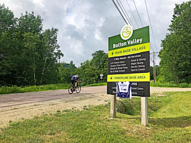
Parking: Two parking spots on the right side of the road at the start of the climb - Map; Street View.
Provisions: There may be a café open at the ski resort at the finish of the climb. There are also several spots for food and beverages in Burlington 20 miles west (Map), or Waterbury seven miles east (Map).
Before heading out on any cycling adventure check out our Things to Bring on a Cycling Trip and use our interactive check list to ensure you don't forget anything.
Use the “Routes in Area” button on the menu bar to see other bike climbs in this area.
There are the gaps (Lincoln, Appalachian, and Roxbury to the south) and Mount Mansfield to the north (only open for bikes one day per year, but a wonderful car ride on the toll road to the highest point in Vermont).
ROUTE MAP
MEMBER RATING
CURRENT WEATHER
PJAMM TRIPS ADVENTURE STARTER BUNDLES
Check out PJAMM Adventure's prepackaged (self-guided) cycling trips. They will help you plan, document and conquer your next adventure.
NEARBY CLIMBS (0) RADIAL PROXIMITY
FROM No Climbs Found
MEMBER REVIEWS & COMMENTS
Let us know what you thought of this climb. Signup for our FREE membership to write a review or post a comment.
Already have an account?
LOG IN HERE
Mikey62481
Tough climb that slaps you in the face right off the bat as the first incline and first overall mile is rather steep. We climbed this on a somewhat warm day in august in the low 80s and it was a good challenge. The road had a mix of sun and shade throughout. The hardest part of the climb comes right before the 3 mile mark right before the Timberline Lodge on the right, extremely steep section, perhaps close to 20% at times. The lodge was good place to stop for a quick gel/water break to cool down, before finishing up the last 1.2 miles, which is a pretty steady grade that you can get into a rhythm.
Descent: very good descent but be careful as you can fly down it, the road is in very solid condition for the most part—the last mile or so down wasn't the best but not horrible.
Jbasil626
Steep sections and right at the beginning! There are multiple spots where it exceeds 20%, they are short but cause a lot of pain where they are anyway. Decent is a bit harrowing in my opinion as well, be careful and stop to cool your brakes or wheels.....