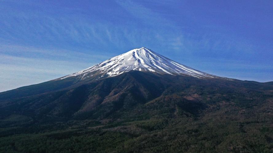
You will not find a more distinctive mountain anywhere.

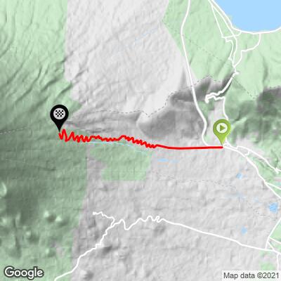
Cycling Mt. Fuji on Route 150 from Oyama-chō to the Komitake Shrine - a Top 100 World Climb up the tallest mountain in Japan. We begin our climb by traveling east on Higashi-Fuji-Goko Road (Road 138) and traveling about 6 miles / 10k up 35+ hairpins to Fuji Azami Line Fifth Station. From here we can walk several more miles to the summit of Mt. Fuji, but it is an impossible path by any type of bike.

Photo from Kaleb Kimbrell, Tokyo and San Diego
Sadly, it was raining and snowing on our day up Mt. Fuji May 4, 2019
![]()
Mt. Fuji as seen from the International Space Station.
![]()
Mt. Fuji is holy to the Japanese. The great artist Hokusai did a number of famous views and Studies of Mt. Fuji:
https://www.metmuseum.org/art/collection/search/78803. One of them is famous and has been co-opted by advertisers and capitalists. It’s on the opening page of the Wikipedia article: https://en.wikipedia.org/wiki/Thirty-six_Views_of_Mount_Fuji

Just a bit up the road from the start.


Raining at the bottom and snowing at the top May 4, 2019.


A shame we couldn’t get the drone up over these magnificent hairpins.

Very steep climb - steepest ½ km 17%, 1 km 15%, 2 km 14%

Climb is on Highway 150 the from start to finish - minimal traffic.

Finish at Fuji Azami Line 5th Station.
WHAT A TRIP
The ascents to the four 5th Stations was first, but by no means the only, stop on our Top 100 World Cycling Asian adventure.

PJAMM’s May, 2019 Asian Trip Itinerary.
![]()
Big-time adventurer Kyle Stanton-Wyman, Bremerton, WA writes for the hike up to Mt. Fuji (as part of our bike-hike sometime in the future):
In regards to a Fuji summer summit - yes I have done that once and it is much more achievable. I climbed the Gotemba route in August of '18 during the official climbing season. Strava link for details and photos: https://www.strava.com/activities/1153817882/overview
Fuji (when snow free) is a 'simple' hike and doesn't require any technical climbing skills or equipment, but it is still a very strenuous hike. Gotemba is the longest of the four routes at 7,400 vft, and the other three are around 4,000 vft. Beware that you might suffer from the high altitude, given the summit is at 12,388 ft. It is most popular to start the hike pre-dawn, and summit in time for sunrise as that is typically when the weather is clearest. Given the peak's isolated nature, it is often obscured in clouds by the afternoon. Also be warned that the three shorter trails are EXTREMELY busy during the official climbing season, especially on weekends (check out the picture of the traffic jam of hikers on my strava link). During the official climbing season there are also open noodle huts selling food and water on the summit. Outside the official climbing season, the summit may still be relatively snow free and easy to hike, especially in early fall, and there will be far fewer people, but no services.
Lastly, here are the three rules for off season climbing: http://www.fujisan-climb.jp/en/risk/guidelines.html
Although the website says it's "prohibited", that's a mis-translation. They just want to make sure you are fully prepared for the conditions.
I'm sure you got the road riding beta from Caleb. Based upon that, I think a bike and hike is perfectly possible on any of the 4 routes!
Wikipedia says of Mt. Fuji:
“Mount Fuji is located on Honshu Island, is the highest mountain in Japan at 3,776.24 m (12,389 ft). It is an active stratovolcano that last erupted in 1707–1708, Mount Fuji lies about 100 kilometres (60 mi) south-west of Tokyo, and can be seen from there on a clear day. Mount Fuji's exceptionally symmetrical cone, which is snow-capped for about 5 months a year, is a well-known symbol of Japan and it is frequently depicted in art and photographs, as well as visited by sightseers and climbers.[7]
Mount Fuji is one of Japan's "Three Holy Mountains" along with Mount Tate and Mount Haku. It is also a Special Place of Scenic Beauty and one of Japan's Historic Sites. It was added to the World Heritage List as a Cultural Site on June 22, 2013.” https://en.wikipedia.org/wiki/Mount_Fuji
This website is excellent and tells you all you need to know about hiking to the top of Mt. Fuji - https://www.garyjwolff.com/climbing-mt-fuji.html#1