
44.5
PDI
35.4 mi
DISTANCE
8,844 ft
GAINED
4.1 %
AVG. GRADE
FULL CLIMB STATS
Page Contributor(s): Photo: Google Street View
INTRO
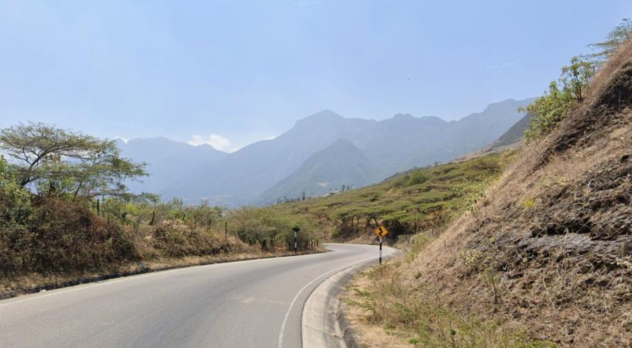
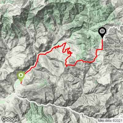
Carrizal is the start of one of Peru's biggest paved climbs: 35.4 miles and 8,844 ft of gain up National Route PE-06A, the highway linking the Lambayeque coast at Chiclayo to Cajamarca's Andean interior. From the hamlet of Carrizal in the Llama District, the road climbs at a 4.1% average grade to just above 9,460 ft near Huambos in Chota Province - a vertical gain roughly equivalent to riding from sea level to the summit of a serious Rocky Mountain pass, in one continuous ascent. With a PDI of a whoppping 44.52, Carrizal currently ranks #68 in our worldwide difficulty database - but unsurprisingly, not the toughest climb in Peru.
What makes it demanding isn't one brutal pitch, it's the sheer duration. The average grade sits in the moderate 4% range, but the steepest 100-yard sections tip over 21%, and there's no summit until you've climbed for the better part of a day. The road also crosses a real climate boundary: Carrizal sits in a warm, dry valley, while the finish near Huambos is cool, often cloudy Andean highland country.
This is a working inter-regional highway, not a quiet backroad - it carries buses and freight between the coast and Cajamarca's interior towns of Chota and Cutervo. Traffic can be heavy. The Chongoyape-Llama section was paved in 2012, and the Llama-Cochabamba section, which covers this entire climb, followed in 2014.
PLAN YOUR ROUTE
 We've partnered with Sherpa-Map.com to bring you the best route planning tool. With a PRO Membership you can use this climb as a reference when creating your route.
 This climb's overall grade is a manageable 4.1%, but don't let that fool you - the opening quarter-mile out of Carrizal averages a punchy 13.2%, and the single steepest 100-yard stretch on the route tops 21%. After that early kick, the gradient settles into a long, grinding ascent with no pitch as hard as the start. See our interactive Profile Tool for the full gradient breakdown by segment.
Roadway: Fully paved for the entire climb. This is Peru's National Route PE-06A, part of the Chongoyape-Cochabamba-Cajamarca highway - the Llama-Cochabamba section that covers this climb was rehabilitated and asphalted in 2014 (the lower Chongoyape-Llama section had already been redone in 2012), so the surface is in good, maintained two-lane condition throughout.
Traffic: This is a working interregional highway, not a quiet backroad - it's the main paved link between the Lambayeque coast (Chiclayo) and the Cajamarca highlands (Chota, Cutervo), so expect a steady trickle of buses, freight trucks, and local traffic the entire way. There's little to no shoulder in most stretches, so ride predictably and take blind curves wide.
Parking: There's no formal trailhead or lot at Carrizal itself - it's a small roadside hamlet. Most riders stage from Llama, a larger town a few miles along the route with basic services, or drive up from Chongoyape or Chiclayo on the coast and park along the shoulder near the hamlet before starting.
This is a long, remote day in the saddle - 35+ miles of continuous climbing with no real services on the mountain itself, so carry more food and water than you think you'll need. Llama, a small town along the lower part of the route, has basic tiendas, but provisions thin out fast once the road climbs into the sparsely populated highlands toward Huambos.
Pack for both ends of the thermometer: Carrizal sits in a warm, dry valley near 1,700 ft, while the finish above 9,400 ft is cool, often cloudy Andean highland country, especially early or late in the day. A light packable layer for the descent is worth the weight.
Gearing matters more than the 4.1% average suggests - the opening stretch out of Carrizal kicks over 13%, with the single steepest 100 yards topping 21%, so don't gear this one off the overall number alone.
Before heading out on any cycling adventure check out our Things to Bring on a Cycling Trip and use our interactive check list to ensure you don't forget anything.
Before heading out on any cycling adventure check out our Things to Bring on a Cycling Trip and use our interactive check list to ensure you don't forget anything.
The nearest airport is Chiclayo (Jose Abelardo Quinones Gonzalez International, CIX) on the Lambayeque coast, roughly 170 km / 3.5-4 hours by road via the same PE-06A highway this climb uses - it's the natural staging point for travelers flying in. Chota, the provincial capital further along the highlands route, is the closer option if you're already traveling in Cajamarca's interior.
Plan around Peru's Andean seasons: the highland finish near Huambos is at its clearest and driest roughly May through September, while the wetter months (October-April) bring a higher chance of afternoon cloud, rain, and reduced visibility at altitude - check current conditions before committing to a summit day.
There's no lodging or services directly on the climb - stage from Chiclayo, Chota, or one of the towns along the highway, and start with a full day's worth of food and water since you won't find much once you leave Carrizal.
ROUTE MAP
MEMBER RATING
CURRENT WEATHER
PJAMM TRIPS ADVENTURE STARTER BUNDLES
Check out PJAMM Adventure's prepackaged (self-guided) cycling trips. They will help you plan, document and conquer your next adventure.
NEARBY CLIMBS (0) RADIAL PROXIMITY
FROM No Climbs Found
MEMBER REVIEWS & COMMENTS
Let us know what you thought of this climb. Signup for our FREE membership to write a review or post a comment.
Already have an account?
LOG IN HERE
