
13.6
PDI
6.6 mi
DISTANCE
2,207 ft
GAINED
6.3 %
AVG. GRADE
FULL CLIMB STATS
Page Contributor(s): Michael Claudio, OR; Craig Sleight, OR; Jeremy S, NV; James Warren, NV
INTRO
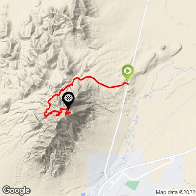
Winnemucca Mountain is the southernmost named summit of Nevada's Santa Rosa Range, rising above the small high-desert city of Winnemucca in Humboldt County. A paved access road climbs 6.6 miles from town to a cluster of radio and communication towers at the summit, gaining 2,207 feet at a 6.3% average grade (PDI 13.6).
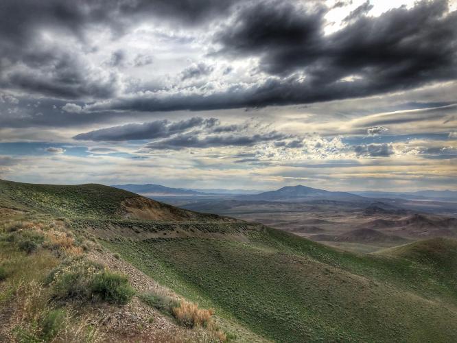
Unlike Nevada's more famous climbs near Reno and Tahoe, Winnemucca Mountain sees almost no traffic - it exists purely to service the radio facilities up top, so cyclists have the road to themselves. The terrain is open high desert (sagebrush, sun, and long views across the Humboldt River valley), with the reward at the top being a wide panorama and, at the right time of day, some of the best sunset views in the region.
In June 2025, a wildfire burned roughly 2,300 acres on the mountain, so riders should expect a changed landscape along parts of the route and should check current road and access status before heading out.
PLAN YOUR ROUTE
 We've partnered with Sherpa-Map.com to bring you the best route planning tool. With a PRO Membership you can use this climb as a reference when creating your route.
 Winnemucca Mountain climbs 2,207 feet over 6.6 miles at a 6.32% average grade (PDI 13.64). The climb starts steepest and gradually eases: the opening quarter mile averages 10.26%, the first mile still averages 8.91%, and by the 2.5-mile mark the average has settled to 7.22%. The back half is more forgiving, with the 5-mile average down to 6.69%, though there's no flat recovery section - the grade eases rather than levels off.
Pace conservatively off the start - the steepest riding comes in the first mile, not the last. Riders who prefer a hard opening pitch that mellows out will like this profile; riders looking for a late, punchy finish won't find one here.
Traffic: Usually none. Winnemucca Mtn Rd is a dead-end utility access road that exists to service the summit's radio and communication towers, so there's no through-traffic - only the occasional maintenance vehicle.
Road surface: Poor. The pavement is aged and patched in sections rather than freshly resurfaced - expect cracks and rough patches typical of a lightly-maintained utility road, not smooth new asphalt.
Parking: There is no dedicated cycling parking area at the base. Riders typically park in Winnemucca proper, near the south end of town close to where Winnemucca Mtn Rd begins, and ride from there.
No water, food, or services exist anywhere on the climb - this is a remote utility road through open desert, so carry everything you'll need for the full out-and-back. Standard road gearing (compact crank, wide-range cassette) handles the sustained 6-7% grade comfortably; a lower gear helps on the steeper opening mile, which averages near 9%.
The road is fully exposed with essentially no shade, so sun protection matters more here than gearing choice - sunscreen, arm coverers, and a light-colored jersey are worth bringing, along with more water than the distance alone would suggest. Given the wildfire that burned part of the mountain in June 2025, it's worth checking current conditions before you go.
Before heading out on any cycling adventure check out our Things to Bring on a Cycling Trip and use our interactive check list to ensure you don't forget anything.
Ride early morning or evening. The slope is fully exposed with no tree cover, so it heats up fast once the sun is up, and Winnemucca Mountain Road is known locally as one of the best sunset-viewing spots in the area, looking out over the Humboldt River valley.
Winnemucca sits directly on I-80 about 165 miles east of Reno, which makes this an easy way to break up a longer Nevada road trip or a standalone target for anyone collecting high-desert summits. Because a wildfire burned part of the mountain in June 2025, check current conditions with the city of Winnemucca before planning a visit in case of lingering access issues.
ROUTE MAP
MEMBER RATING
CURRENT WEATHER
PJAMM TRIPS ADVENTURE STARTER BUNDLES
Check out PJAMM Adventure's prepackaged (self-guided) cycling trips. They will help you plan, document and conquer your next adventure.
NEARBY CLIMBS (0) RADIAL PROXIMITY
FROM No Climbs Found
MEMBER REVIEWS & COMMENTS
Let us know what you thought of this climb. Signup for our FREE membership to write a review or post a comment.
Already have an account?
LOG IN HERE
