INTRO
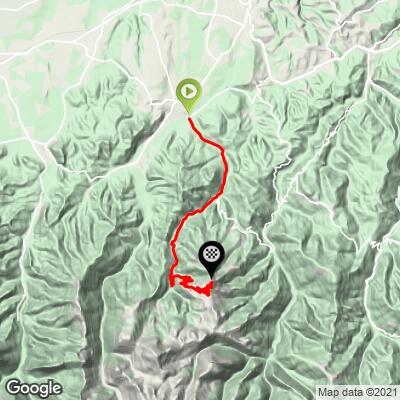
Monte Malanotte climbs 20.8 km (12.9 mi) from Gosi, below Frabosa Sottana, up the Val Maudagna through the ski resorts of Artesina and Prato Nevoso to finish at the Baita Malanotte, just below the 1741 m (5,712 ft) summit. It gains 1234 m (4,050 ft) at a 6.0% average, and the last 2.1 km (1.3 mi) above the Colla del Prel make it the highest paved road in the Monregalese.
It's a climb of two halves. The first 8 km (5.0 mi) are a gentle valley approach at 2-5%, but from around km 8 the road kicks up and barely relents, holding 7-9% for more than 12 km (7.5 mi) through the forest to Artesina and on to Prato Nevoso. The finale is the most unusual part: from the broad Colla del Prel saddle, Via Malanotte hairpins up between the resort's apartment blocks, twice passing through short artificial tunnels beneath the buildings, before the final narrow, steep hairpins lead to the summit plateau.
Prato Nevoso has real racing pedigree: the Tour de France finished there in 2008, when Simon Gerrans took his first Tour stage win, and the Giro d'Italia has also finished there, most recently in 2000 with a stage win for Stefano Garzelli. From the top on a clear day the view reaches Monte Rosa to the north, Monviso above Cuneo, and even Mont Blanc and Gran Paradiso in the distance.
PLAN YOUR ROUTE
 We've partnered with Sherpa-Map.com to bring you the best route planning tool. With a PRO Membership you can use this climb as a reference when creating your route.
 Monte Malanotte is 20.8 km (12.9 mi) long with 1234 m (4,050 ft) of elevation gain, an average grade of 6.0%.
The first 8 km (5.0 mi) are an easy warm-up at 2.5-5% along the Val Maudagna. Things change abruptly at km 9, which averages about 9.4%, and from there the climb is relentless: every kilometer from km 9 to km 17 sits between 6.7% and 8.8%, with no real respite through Artesina and Prato Nevoso.
There's a short easing around km 19 (about 4.7%) as you reach the Colla del Prel, then the final 2.1 km (1.3 mi) up Via Malanotte average about 6-6.5% - gentle through the first hairpins, then steeper and narrower after the fifth hairpin all the way to the top.
Steepest sections: 0.5 km (0.3 mi) at 10.0%, 1 km (0.6 mi) at 9.0%, 2 km (1.2 mi) at 8.5%, 5 km (3.1 mi) at 7.9%, and 10 km (6.2 mi) at 7.8%.
Roadway: Paved to the top. The provincial road up to Prato Nevoso is clean but has plenty of small cracks and dips, so stay alert on the descent. From Prato Nevoso to the Baita Malanotte the asphalt was relaid in 2017 and is in good shape, though watch for drainage channels across the road on Via Malanotte, which also narrows noticeably on its final hairpins.
Traffic: Light for most of the year. On summer weekends expect families driving up from the plains to escape the heat. In winter this is the access road to the Mondolè Ski area, so it's busy and often icy - not a road for cycling in ski season.
Parking: Frabosa Sottana, which the route passes through around km 4, is the natural base and the easiest place to park near the start. At the top there's a large parking area at the Baita Malanotte, handy if someone is meeting you there or you'd rather ride only the upper half from Artesina or Prato Nevoso.
Provisions: Frabosa Sottana, around km 4, has the most reliable services on the route. Artesina and Prato Nevoso are ski resorts, so services there are seasonal and thinner in summer. At the top, the Baita Malanotte's bar-restaurant, beside the chairlift stations, is typically open in high summer (roughly late July to mid-September) - a great spot for lunch with a view.
Gear: Standard road gearing handles this, but after the easy first 8 km you'll be on 7-9% grades for a long time, so a compact or a large cassette helps. The summit is over 1700 m and exposed, so pack a jacket for the long descent.
The Mondovì area rewards a rest day. The Santuario di Vicoforte, just outside Mondovì, has the largest elliptical dome in the world, completed in the 1730s and covered in more than 6,000 square meters of frescoes. In the neighboring Val Corsaglia, the Grotta di Bossea was the first show cave in Italy opened to the public, in 1874, with underground lakes and streams running through its vast chambers.
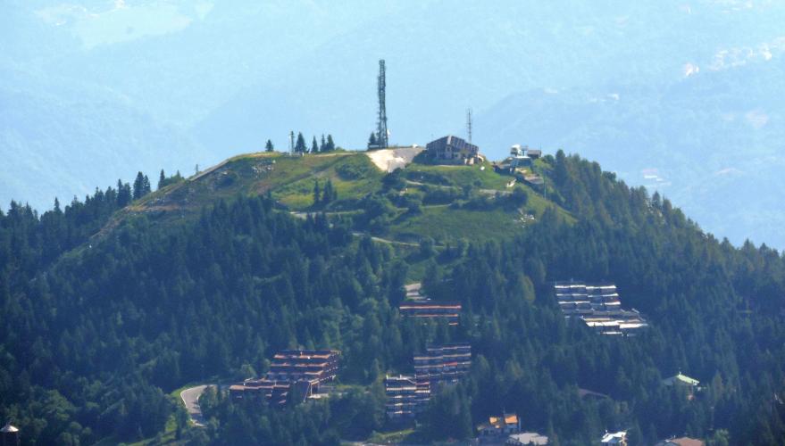
Mondovì itself, with its hilltop old town of Piazza linked to the lower city by a funicular, is the nearest real town and a good base, and the valleys of the Monregalese are packed with other climbs. At the finish, the summit's big telecommunications antenna makes Malanotte easy to pick out from the plain. With a finish above 1700 m, check current conditions before you go with our Weather tool.
ROUTE MAP