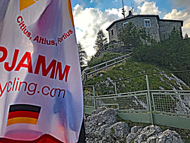
![]() Kehlsteinhaus (Eagle’s Nest)
Kehlsteinhaus (Eagle’s Nest) ![]()
![]()
This is a bucket list historical once-in-a-lifetime-type climb. However, please note ![]() (those signs are posted in too many places to competently or credibly ignore if you get pulled over. Thus, we cannot recommend you do this climb...but...if you decide to give it a go...here’s how we did it (but you shouldn’t...).
(those signs are posted in too many places to competently or credibly ignore if you get pulled over. Thus, we cannot recommend you do this climb...but...if you decide to give it a go...here’s how we did it (but you shouldn’t...).
- Start well before sunrise. We stayed in Berchtesgaden (at Hotel Wittelsbach[1] in Berchtesgaden, Bavaria) which is right at the beginning of the climb, a one kilometer ride downhill to the start.
![]()
Berchtesgaden, Bavaria, Germany (you’ll want to stay here).
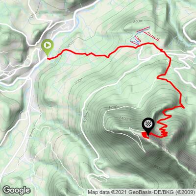
- The safest route is the route on our Climb Page -- it is posted
![]() at about the 3.6 km point and well posted in that regard thereafter. However, much of that route is a footpath so no problem there. One PJAMMer took the main road to the top without incident (see slideshow “Main Road -- More Off Limits Route”). And, while the more rogue among us had no incident getting up and down, we simply cannot even suggest you try that route (if you go against our direction not to try it at all...).
at about the 3.6 km point and well posted in that regard thereafter. However, much of that route is a footpath so no problem there. One PJAMMer took the main road to the top without incident (see slideshow “Main Road -- More Off Limits Route”). And, while the more rogue among us had no incident getting up and down, we simply cannot even suggest you try that route (if you go against our direction not to try it at all...).
![]()
Footpath Route
![]()
The main road route
![]()
Tunnels along the main road
- Do not dally around at the top. It takes a good 2 hours to get to the top (the final 900 meters is very steep on gravel with hairpins) and you should time it so you arrive there around 7 a.m. (sunrise was at 5:30 the day we started which is precisely when we began the climb that morning).
- It’s best to use wide tires with some grip as the final 900 meters cannot be cycled on regular road tires.

There it is - the Eagles Nest - as reconstructed after the allies and germans destroyed it in 1945
Wikipedia notes:
“The Kehlsteinhaus (known as the Eagle's Nest in English-speaking countries) is a Third Reich-era building erected atop the summit of the Kehlstein, a rocky outcrop that rises above the Obersalzberg near the town of Berchtesgaden. It was used exclusively by members of the Nazi Party for government and social meetings. It was visited on 14 documented instances by Adolf Hitler, who disliked the location due to his fear of heights, the risk of bad weather, and the thin mountain air. Today it is open seasonally as a restaurant, beer garden, and tourist site.
The Kehlsteinhaus sits on a ridge atop the Kehlstein, a 1,834 m (6,017 ft) subpeak of the Hoher Göll that rises above the town of Berchtesgaden. It was commissioned by Martin Bormann in the summer of 1937. Paid for by the Nazi Party, it was completed in 13 months. Hitler first visited on September 16, 1938, and returned on April 20, 1939, for its formal presentation as a gift for his fiftieth birthday. A 4 m (13 ft) wide approach road climbs 800 m (2,600 ft) over 6.5 km (4.0 mi). Costing RM 30 million to build (about 150 million inflation-adjusted euros in 2007), it includes five tunnels but only one hairpin turn.” Wikipedia

The views from start to finish are spectacular.
We suggest cycling one day just to the visitor center/bus staging area which is about three kilometers into the climb. That will permit you to get some nice photos during the day and get a sense of the first part of the climb. There is a nice restaurant at the three kilometer mark.

Very steep on the ride up to the bus staging area.

Buy tickets and load bus at km 3.

Veer left at km 3.

Ooop, going so damn fast didn’t see that sign . . .
![]()
![]() From km 3.7 to top.
From km 3.7 to top. ![]()
![]()
There are several spots along the way where the Eagles Nest can be seen from (far) below.

Eagles Nest with four kilometers left to climb (yes -- a severe lies gradient ahead).
![]()
We are on a mostly paved footpath for the second half of the climb.

Start early -- you won’t regret it -- experience the sunrise (and stay out of jail).

Tunnel to elevator to the top.
However, we take the footpath to the top which is just down the mountain 50 meters from the upper parking lot. The path is mostly gravel and with thirteen very tight hairpins. The final 900 meters is at a mild 7% grade, but dealing with the gravel and super tight turns is quite the challenge, and there is an 18% 120 meter section just before the top to contend with.

Footpath just below upper parking lot.

No one will be riding up the last 30 meters!

There is a footpath from the Eagles Nest to many lookouts and a cross.

One of many extraordinary views on a clear day from the top.

An accomplished and entertaining accordion player performing at the cross.
![]()
PJAMM at the high point.
Steepest Gradients by Distance
![Grade.JPG]()
Here is an excellent summary from Jerry’s Tours of his bootleg journey to the Eagle’s Nest.
Our friend Patrick Morris of Veloasia.com and Indo China Travel writes:
Attached is the GPX from the Eagles’ Nest Strava ride:
https://www.strava.com/activities/2598635779
As you can see, a lot of zig-zagging around the “Dokumentation” bus terminal trying to figure out the way up midday. I found the the Rosenfeld Panoramic highway, dirt road, and hiking path have no signs about bikes and assume it’s perfectly fine.
The important thing about Kehlsteinhaus, which you do mention, is that once you reach the top, you are not at the top – just the bus area, and that narrow footpath is another 20 minutes up. There’s a no biking sign, and I thought there would be staff to turn you away as well, but were not. It is ridable though, until the two brief sections of stairs, not much harder than the hiking trail up, but only about 3 feet wide of course. If it’s a busy period, then it would be a big hassle, but when I walked down on my 2nd visit it was mostly empty – in the mid-afternoon.
We have confirmed with several Strava members who have ridden this climb (our posted route) that it can be done on a road bike. Below are some of their responses:
- Hallo, yes it is. You can climb with your road bike up to the top, approx. 25 metres below the Eagles Nest (last 25 metres are steps).
- Hi John, the Kehlsteinstraße Climb is paved up to the parking lot (yes, you can do it on a road bike), with the exceptions of the five tunnels along the way. The tunnels are paved with cobblestones and they are not lit up, so I would definitely recommend bringing some bike lights. From the parking lot there is a route up to the Kehlsteinhaus, but it's not rideable. It's more of a hike. Also keep in mind that the route up there is closed during the day and only open for the buses. So it's only allowed and recommended to go up there either before the buses start to run in the morning or after the last bus made its route down in the evening, which usually is around 6pm. Having said all that, there is a little bit of planning involved with this climb, but it's sure worth it.
- The first bus runs at 7.40am. There is a gate at the bottom of the climb and I don't know if its open before that. The road itself is only open to the buses, but as far my information goes, bikes are tolerated, before or after the buses run. The reason is that the road is pretty narrow and there is simply not enough space to sidestep. There is another way up, if this one is closed, but it involves unpaved sections and is usually only used by mountain bikers. Here is some information, including the timetable of the buses: http://www.kehlsteinhaus.com/the-location/hintereck.html
- Yes, I think you can ride in the morning, but you would need to start quite early -- see the timetable of the buses here: http://www.rvo-bus.de/oberbayernbus/view/mdb/kursbuch/mdb_247720_849.pdf. Please note that when we climbed the last buses still followed the summer schedule (you can check via email, berchtesgaden@rvo-bus.de whether the earliest/latest buses still go by the end of September or not). Also, I believe that the temperature was far better in the evening. In the very beginning, there was one bar that we needed to ride on the side. Also, please check carefully where we started to climb -- you are crossing the main road via bridge, so you need to hit the right road before the crossing.
- Hi! During the daytime the road to the Eagles Nest is closed for the public traffic between May and the end of October. You can ride with a road bike in the very early morning (before 8 am) or at the evening (past 5.30 pm); the road is paved and a public bus runs up to the Eagles Nest, but not to the very top. 100 meters under the eagles nest the busline ends; from here you have to walk or use an elavator. So the last section you cannot do with a road bike.
- Hello, the wide road (there are buses) goes up to about 100 meters below the Kehlsteinhaus. After that is a tarred footpath (narrow and very very narrow curves) to just below the Kehlsteinhaus (Is well passable, some persons who are not quite dizzy have problems). Upstairs are 2 sets of stairs (estimated 20 steps). Because you can wear the bike well. Then you are at the Kehlsteinhaus. I usually go to here. Above the Kehlsteinhauses is a wide footpath with underground sand to the Kehlsteingipfel (50 altitudes).
- Hi John, yes it is possible. You can climb on a road bike to the place where the bus stops at the top without any trouble on a road bike -- the asphalt is very good. The trouble is 15+% gradient in majority of the climb and the fact that you can only try to climb after the last bus passes, which is normally after 17:05 -- even after that, there are signs that prohibit access via car/bike and even walking, but since the buses are over, the road is basically yours ;) Anyway, some 20m before reaching the parking, there is sharp right turn to very narrow (around 60cm) and steep asphalted route with many harpins which leads to the very top. And it is doable on a road bike, although I had troubles to turn into the sharp harpins. Last 20m altitute meters are stairs. To have an idea how it looks like, see this video: https://www.youtube.com/watch?v=sjnFd9YWbVs
[1] We receive no benefit from posting this name; we stayed there and it was a nice place but there are likely many options in Berchtesgaden that are just as good.