
19.5
PDI
12.3 mi
DISTANCE
3,625 ft
GAINED
5.6 %
AVG. GRADE
FULL CLIMB STATS
INTRO
PLAN YOUR ROUTE
 We've partnered with Sherpa-Map.com to bring you the best route planning tool. With a PRO Membership you can use this climb as a reference when creating your route.
The climb averages 5.6% over 19.7 km (12.3 mi). The steepest 500 m averages 9.1% (9.2% for the steepest quarter mile), the steepest 1.6 km (1 mi) holds 7.9%, and the steepest 5 km (3.1 mi) holds 7.0%. Even the steepest 10 km (6.2 mi) averages 6.1%, so there is little rest on the way up.
The opening 2 km (1.2 mi) are the gentlest at 4 to 5%. The only real recovery comes between about 9.9 km and 11.8 km (6.2 to 7.3 mi), where the road eases to roughly 1.1%. The final 5.9 km (3.7 mi) then average 6.0% to the finish.
Roadway: The road is paved all the way, running along the SP14, then the SP107 and SP216 as it climbs through Alto and Caprauna. Ride reports consistently describe the surface as good, and the upper valley road is narrow and winding.
Traffic: Traffic is light throughout, with mostly local cars passing through the small villages. It is noticeably quieter than the neighboring Colle di Nava.
Parking: The start is a rural stretch of the SP14 near Vignoletto in Nasino with no signed trailhead lot, so we recommend starting from the coast at Albenga, which has a train station and a full range of services. Riding up the valley on the SP582 and SP14 makes the full ascent from Albenga about 36.3 km (22.6 mi).
Provisions: The climb passes only small villages (Nasino itself has around 174 residents), so fill both bottles and carry food before leaving the coast or the valley floor.
Gear: No special equipment is needed. A compact crankset with a 28 to 30 tooth largest cog is comfortable for the 5.6% average and the 9% ramps.
Weather: The pass is about 1,100 m (3,600 ft) above the start, so pack a light jacket for the descent. The main riding season runs from April to October.
Before heading out on any cycling adventure check out our Things to Bring on a Cycling Trip and use our interactive check list to ensure you don't forget anything.
Albenga makes the easiest base for this climb. It has a train station on the coastal line and the widest choice of hotels, restaurants and bike-friendly services in the area, and the valley road to Nasino starts right behind it.
Up the valley, Castelbianco (341 m / 1,119 ft), a neighbor of Nasino, is a good spot for a coffee stop on a longer day. In Caprauna, look for the local rapa di Caprauna turnip on menus. A popular loop from the coast links Colle San Bernardo and Colle di Caprauna for about 110 km (68.4 mi) with 1,780 m (5,840 ft) of climbing, and the neighboring crossings are on our Colle di Nava and Colle San Bernardo pages. Browse other cols within a day ride with our Routes in the Area tool.
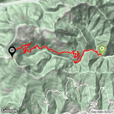
ROUTE MAP
MEMBER RATING
CURRENT WEATHER
PJAMM TRIPS ADVENTURE STARTER BUNDLES
Check out PJAMM Adventure's prepackaged (self-guided) cycling trips. They will help you plan, document and conquer your next adventure.
NEARBY CLIMBS (0) RADIAL PROXIMITY
FROM No Climbs Found
MEMBER REVIEWS & COMMENTS
Let us know what you thought of this climb. Signup for our FREE membership to write a review or post a comment.
Already have an account?
LOG IN HERE
