Fully - L'Erie Bike Climb - PJAMM Cycling

13.7
FIETS
9.5 mi
DISTANCE
4,701 ft
GAINED
9.2 %
AVG. GRADE

FULL CLIMB STATS

INTRO

This 9.5 mile bike climb is located in Valais, Switzerland. The average gradient is 9.2% and there is a total elevation gain of 4,701 ft, finishing at 6,133 ft.

Use the profile tool, route map, and weather forecast to conquer this cycling climb.

See more details and tools regarding this climb's grade via our interactive Profile Tool.
Information Not Available

If you have any information regarding this climb, we'd like to hear from you. Click the CONTRIBUTE button to share your thoughts with us.

Information Not Available

If you have any information regarding this climb, we'd like to hear from you. Click the CONTRIBUTE button to share your thoughts with us.

Before heading out on any cycling adventure check out our Things to Bring on a Cycling Trip and use our interactive check list to ensure you don't forget anything.
Information Not Available

If you have any information regarding this climb, we'd like to hear from you. Click the CONTRIBUTE button to share your thoughts with us.

ROUTE MAP

MEMBER RATING

Not Yet Rated
-
Road
-
Traffic
-
Scenery

CURRENT WEATHER

PJAMM TRIPS ADVENTURE STARTER BUNDLES

Check out PJAMM Adventure's prepackaged (self-guided) cycling trips. They will help you plan, document and conquer your next adventure.
ALL TRIPS
Browse all of our prepackaged trips and find your next adventure!

NEARBY CLIMBS (0) RADIAL PROXIMITY

FROM
No Climbs Found

MEMBER REVIEWS & COMMENTS

Let us know what you thought of this climb. Signup for our FREE membership to write a review or post a comment.
Already have an account?
ROUTE MAP
PROFILE TOOL
Route Data
S.G. (%)
hide
Segment Data
hide

Climb Profile Not Found
CLIMB SUMMARY

Cycling Fully Erie - mountains, martigny

Cycling Fully-Eerie

Ride 15 kilometers climbing 1,430 meters at 9.2% average grade.

Bike climb Fully Erie - gravel road, tunnel, rock

This is an extremely challenging bike climb out of the Rhone Valley in Switzerland.  The climb begins in the municipality of Fully (pop. 8,769, 2018) in the World Bike Climb area we have named Rhone Valley after the hub of this magnificent bike climbing zone.

Climbing Fully Erie by bike - bike, road, Fully below

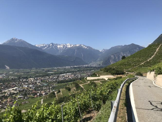
The first 5 kilometers are on a very well paved wide road that takes you through a hillside vineyards and is very scenic.

Climbing Fully Erie by bike - hillside vineyards of Fully

bunch of vineyards. Very scenic. You go through a small village and then the road becomes very narrow one lane road and is VERY steep through a set of hairpins.

Bicycle climb Fully Erie - hairpin and Fully below - mountains

Hairpins at km 4.5 (1 km averages 16.3% here)

Bicycle ride Fully Erie - bike against building on road in Chiboz

Village of Chiboz at kilometer 8.5

At approximately kilometer 9 (6 km from the top) the road turns to gravel. Good swiss gravel, but a gravel bike with knobby tires would have been preferred (we did use a road bike with 30mm).  

Biking Fully Erie - road and road sign

There is very little traffic over the last half of this gorgeous bike climb that winds its way up the mountain and at times permitting nice views of Martigny far below.

Cycling Fully Erie - road, mountains and Martigny below

View back towards Rhone Valley from top of climb.

A note on the descent: very very treacherous. Use caution! Especially descending the gravel part at the top. If you misjudge a corner it's a long way down. Once on the pavement, it's difficult to brake hard enough to safely navigate the incredibly steep (20%+) hairpins and cars are not expecting an insane cyclist on this road!  

Grades.JPG

Access to full Climb Summary requires a PJAMM Cycling PRO Membership!

It takes less than a minute to sign up & with your PRO membership you can:
  • Rate climbs, post comments and share your experiences on any of our climb pages
  • Create bucket lists of climbs & mark the dates you complete them
  • Weather data for all climbs - Start & Finish
  • Upload photos to your member page to customize your PJAMM Cycling experience
  • Utilize all of our interactive tools - Profile & Routes in Area
  • Download climb route .gpx files
LEARN MORE
SIGN UP

Already have an account? LOG IN HERE