INTRO
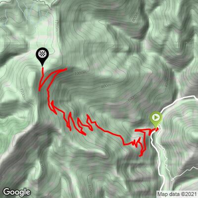
Sella di Gouta climbs 13.7 km (8.5 mi) from the floor of the Val Nervia below Pigna to a forested saddle at 1213 m (3,980 ft), gaining 1046 m (3,431 ft) at a 7.4% average. The road is the SP69, a narrow provincial road that winds up the mountainside in around 20 hairpins and simply stops at the top - beyond the saddle, only dirt roads and trails continue - so it carries almost no traffic.
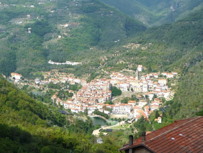
It is a climb of two halves in character. The first 4 km (2.5 mi) are open and sunny, with the olive terraces and the stacked houses of Pigna dropping away beneath you, and they carry the best pavement of the day. Then the road dives into the forest, and the Mediterranean hillside gives way to something that feels far more Alpine: the Foresta di Gouta-Testa d'Alpe, a big stand of silver fir, beech, mountain maple and Scots pine growing just 15 km (9.3 mi) from the sea. The grade is irregular throughout, with short double-digit pitches broken up by easier stretches, so settle in and ride by feel.
At the top, the Rifugio Gola di Gouta sits on the saddle, a stage stop on the Alta Via dei Monti Liguri long-distance trail and one of the few summits in this corner of Liguria where you can sit down to a proper meal. It's a quiet, wild, little-known climb - exactly the kind of road that rewards the rider who goes looking for it.
PLAN YOUR ROUTE
 We've partnered with Sherpa-Map.com to bring you the best route planning tool. With a PRO Membership you can use this climb as a reference when creating your route.
 Sella di Gouta is 13.7 km (8.5 mi) long with 1046 m (3,431 ft) of elevation gain, an average grade of 7.4%, with about 35 m (115 ft) of descending along the way.
There's no warm-up: the first kilometer off the valley road averages 8.8%, and the whole first half stays between about 7% and 8.8% per kilometer - the hardest sustained work of the climb, and, being unshaded, the hottest on a summer afternoon. From km 6 the grade relaxes to 6.5-7.5% through the forest, with another harder kilometer at 8.3% around km 9-10. The last few kilometers ease to around 5-6%, with one more kick near 8% before the final, gentler run to the saddle.
The kilometer averages hide how irregular it is: short ramps well into double digits alternate with near-flat recovery stretches all the way up. Steepest sections: 0.5 km (0.3 mi) at 11.8%, 1 km (0.6 mi) at 10.5%, 1 mi (1.6 km) at 9.5%, 2 km (1.2 mi) at 9.2%, 5 km (3.1 mi) at 8.4%, and 10 km (6.2 mi) at 7.8%.
Roadway: Paved all the way on the SP69, a narrow mountain road with around 20 hairpins. The open lower section has the best surface; once you enter the forest the asphalt is patchier, with rough and broken stretches and occasional loose stones - nothing that troubles a road bike on the way up, but take the descent carefully. The pavement ends at the saddle, where unpaved roads continue into the forest and along the Alta Via dei Monti Liguri.
Traffic: Very light. It's a dead-end paved road, so the only vehicles are locals, visitors driving up to the rifugio, and the odd hiker - on a weekday you may count the cars on one hand.
Parking: Pigna is the natural base, a short ride from the start at the SP69 junction below the village - see our Colle Melosa (Pigna) page for parking in the village. At the top there's space to park at the saddle by the Rifugio Gola di Gouta.
Provisions: Fill up in Pigna, or on the way up the Val Nervia in Dolceacqua or Isolabona - there's no reliable water on the climb itself. At the top, the Rifugio Gola di Gouta reopened for the 2026 season on May 1 under new family management; it serves mountain cooking, with a full menu on Saturdays and Sundays, and has three dormitory rooms if you want to stay the night.
Gear: A compact with a 30- or 32-tooth cog is a good match for the irregular 8-10% pitches. Slightly wider tires (28 mm or more) make the patchy forest section and the descent more comfortable, and a gravel bike opens up the dirt roads beyond the saddle. The first 4 km are fully exposed, so carry extra water on a hot day.
The reason to linger at the top is the forest. From the saddle, a wide unpaved road heads into the Foresta di Gouta-Testa d'Alpe toward Colla Scarassan and Passo Muratone, and deeper in the woods the flat meadows of Margheria dei Boschi, with the Barbaira stream running through them, are a favorite picnic spot for families from the coast. The forest is part of the Parco Naturale Regionale delle Alpi Liguri, and the Alta Via dei Monti Liguri passes right by the rifugio - on a gravel bike, the dirt roads around Margheria dei Boschi make an easy loop, with Monte Toraggio (1971 m) rising over the trees.
Down in Pigna, besides the spiral-built old town and thermal spa covered on our Colle Melosa (Pigna) page, look for the church of San Bernardo, a short walk outside the village in the cemetery, where Giovanni Canavesio painted one of the finest 15th-century fresco cycles in Liguria, signed and dated 1482. Pigna also starts our Colle Melosa climb, and Castel Vittorio, facing Pigna across the valley, is another nearby climb - see other climbs nearby, or build a custom route from here, with our Routes in the Area tool.
ROUTE MAP