
19
PDI
14.4 mi
DISTANCE
3,997 ft
GAINED
4.1 %
AVG. GRADE
FULL CLIMB STATS
INTRO
This is the long way into the far upper Valle Argentina. From Molini di Triora the route climbs 23.0 km (14.3 mi) to 1,408 m (4,618 ft), gaining 1,218 m (3,997 ft) at a 4.1% average. That average is kept low by a 130 m (427 ft) drop in the middle and a few shorter dips, so the climbing itself is harder than the number suggests. It ranks #1111 on our list of the world's hardest climbs.
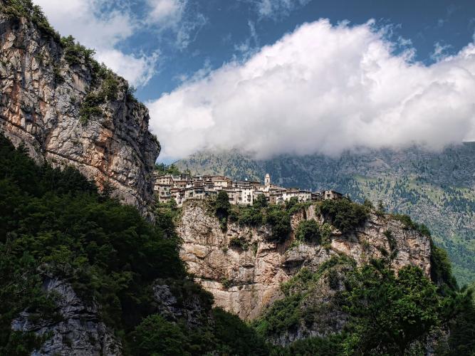
The route passes through three very different worlds. It first climbs to Triora, the famous "village of witches," then drops into the gorge to cross the Ponte di Loreto, a 1950s concrete bridge with dizzying views straight down into the valley. Beyond it a quiet road traverses the steep valley side past the hamlet of Creppo and climbs to the Ponte della Pace below Verdeggia, about 15 km (9.3 mi) in.
From the bridge our route doubles back to Realdo, perched on a rock spur high above the Argentina, and takes on the hardest climbing of the day: a narrow former military road that zigzags up through the stone hamlet of Borniga at 6-10%, ending at 1,408 m (4,618 ft) with the ridges of the French border above you. It is quiet and remote, and a world away from the coast you left behind in Taggia and Sanremo.
PLAN YOUR ROUTE
 We've partnered with Sherpa-Map.com to bring you the best route planning tool. With a PRO Membership you can use this climb as a reference when creating your route.
From Molini di Triora the route averages 4.1% over 23.0 km (14.3 mi), with 1,218 m (3,997 ft) of climbing and 276 m (906 ft) of descending along the way. Broken into sections:
Molini to Triora (km 0-5): 4.8-7.0%, rising to about 760 m (2,493 ft).
Descent to the Ponte di Loreto (km 5-7): about 130 m (427 ft) down, at up to 8.8%.
Loreto to the Ponte della Pace (km 7-15): a long traverse at mostly 1.6-5%, then a 7.5% kilometer between km 12 and km 13 and a 10.5% final kilometer up to the bridge at about 1,040 m (3,412 ft).
Realdo to the top (km 16.3-23): the real climb - 5 km (3.1 mi) averaging 7.8% from Realdo (about 1,000 m / 3,281 ft), with a 9.5% kilometer between km 18 and km 19, before the last 1.7 km (1.1 mi) roll gently to 1,408 m (4,618 ft).
The steepest 1 km (0.6 mi) averages 10.6%, the steepest 2 km (1.2 mi) 8.8%, and the steepest 5 km (3.1 mi) 7.4%.
Roadway: Paved throughout. A provincial road climbs from Molini to Triora; from there narrower mountain roads cross the Ponte di Loreto and run up the valley side to the Ponte della Pace and Realdo, and the final section above Realdo follows a narrow, paved former military road that zigzags up through Borniga. These are small, steep-sided mountain roads, so expect patched surfaces and take the descent with care. Beyond our finish the same road heads on toward the Bassa di Sanson, where the unpaved military roads of the border ridge take over. Snow can close the upper valley in winter.
Traffic: Very light beyond Triora - mostly residents of the upper-valley hamlets and hikers heading for the trails around Realdo and Verdeggia. The road up to Triora sees more visitors, especially on summer weekends.
Parking: Parking in Molini di Triora is covered on our Colle Melosa (Molini di Triora) page. If you want to skip the first 5 km (3.1 mi), Triora has a public car park by the entrance to the village, near the witchcraft museum, and starting there still leaves you the whole upper valley.
Provisions: Molini di Triora and Triora are the places to fill bottles and buy food. Beyond Triora the hamlets are tiny and services are few, so carry enough for the whole ride.
Gear: A compact crankset with a 30- or 32-tooth cog suits the 8-10% pitches above Realdo, and tires of 28 mm or wider make the patched upper roads more comfortable. The finish at 1,408 m (4,618 ft) is noticeably cooler than Molini, so carry a layer for the long descent.
Before heading out on any cycling adventure check out our Things to Bring on a Cycling Trip and use our interactive check list to ensure you don't forget anything.
Triora's witch-trial history and Molini's September snail festival are covered on our Colle Melosa (Molini di Triora) page - this route is the one that takes you deep into the hamlets beyond. Realdo, perched on its rock spur above the Argentina, and Verdeggia, across the valley, were part of Briga Marittima (La Brigue) until the 1947 Treaty of Paris moved them to Italy, and they remain the heart of the Terra Brigasca, a mountain community whose dialect and pastoral traditions straddle the French border. Realdo is also a stage stop on the GTAM, the long-distance hiking route across the Maritime Alps.
Lower down, Creppo has a quieter story worth knowing: during the German occupation, villager Francesco Moraldo hid two Jewish orphans in his home with the help of the village, and in 1999 Yad Vashem recognized him as Righteous Among the Nations.
The upper valley sits below Monte Saccarello, Liguria's highest peak, and conditions up there can change quickly, so check current conditions before you go with our Weather tool.
ROUTE MAP

MEMBER RATING
CURRENT WEATHER
PJAMM TRIPS ADVENTURE STARTER BUNDLES
Check out PJAMM Adventure's prepackaged (self-guided) cycling trips. They will help you plan, document and conquer your next adventure.
NEARBY CLIMBS (0) RADIAL PROXIMITY
FROM No Climbs Found
MEMBER REVIEWS & COMMENTS
Let us know what you thought of this climb. Signup for our FREE membership to write a review or post a comment.
Already have an account?
LOG IN HERE
