
18.1
PDI
13.4 mi
DISTANCE
3,610 ft
GAINED
5 %
AVG. GRADE
FULL CLIMB STATS
INTRO
PLAN YOUR ROUTE
 We've partnered with Sherpa-Map.com to bring you the best route planning tool. With a PRO Membership you can use this climb as a reference when creating your route.
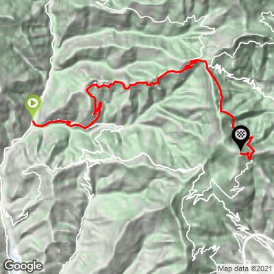
Monte Bignone averages 5.0% over 21.6 km (13.4 mi), but it comes in very uneven pieces.
The first 6 km (3.7 mi) out of Isolabona average 5.9%, past Apricale. The next 5 km (3.1 mi) ease to about 4.1%, before a firmer 3 km (1.9 mi) at 6.4% lifts you into Bajardo at about km 14 (8.7 mi).
From Bajardo, the SP56 follows the ridge for more than 6 km (3.7 mi) at an average of just 3.0%, with gentle rollers and no kilometer above 4.2%.
Then comes the sting. The final 1.1 km (0.7 mi), off the SP56 toward the summit, averages 13.0%: the steepest kilometer is 14.1%, with a 0.5 km (0.3 mi) pitch at 15.3% - by far the hardest riding of the day, saved for the very end.
Roadway: Paved to the finish. The SP63 from Isolabona to Bajardo and the SP56 along the ridge are narrow, winding provincial roads, and riders describe the surface as mostly good, with some rougher patches. The final ramp toward the summit is narrow and very steep, so take the first part of the descent slowly.
Traffic: Light. Riders report little traffic, and these back roads mostly carry local cars to and from Apricale and Bajardo, with even fewer once you're out on the ridge.
Parking: Isolabona is a small village of narrow lanes at the meeting of two torrents, so park on its edge along the Val Nervia road rather than in the historic center. If you're riding several climbs in the valley, Pigna, further up the Val Nervia, is another good base - see our Sella di Gouta page.
Provisions: Isolabona, Apricale (around km 3) and Bajardo (around km 14) are the places to refill. After Bajardo there are no more villages on the route, so top up there before the ridge and the final ramp.
Gear: The first 20 km (12.4 mi) can be ridden on any compact gearing, but the final kilometer at 14.1% calls for your lowest gear - a 34x32 or 34x34 is a sensible choice. The climb starts barely above sea level and finishes more than 1,000 m (3,281 ft) higher, so carry a layer for the long descent.
Before heading out on any cycling adventure check out our Things to Bring on a Cycling Trip and use our interactive check list to ensure you don't forget anything.
Bajardo is the village to stop in. At its highest point stand the roofless ruins of the church of San Nicolò, first documented in 1245. On Ash Wednesday, February 23, 1887, an earthquake brought the roof down on villagers gathered inside for the service, killing more than 200 people. Today the ruins - with the altar and a surviving side chapel still in place - host summer performances and outdoor cinema, and the terrace behind them looks out over the Ligurian Sea one way and the Maritime Alps the other.
At the start, Isolabona takes its name from the Latin insula, for a place where two rivers meet. Above the village are the ruins of a castle the Doria family began after 1287 but never finished; the town has restored them and built an open-air wooden theater inside for summer shows. In Piazza Piccola, look for the octagonal stone fountain dated 1486. For Pigna and the fir forest above it, see our Sella di Gouta page. The hills between the Val Nervia and Sanremo are full of climbs, including Colle Termini di Bajardo and Passo di Ghimbegna - see other climbs nearby, or build a custom route from here, with our Routes in the Area tool.
ROUTE MAP
MEMBER RATING
CURRENT WEATHER
PJAMM TRIPS ADVENTURE STARTER BUNDLES
Check out PJAMM Adventure's prepackaged (self-guided) cycling trips. They will help you plan, document and conquer your next adventure.
NEARBY CLIMBS (0) RADIAL PROXIMITY
FROM No Climbs Found
MEMBER REVIEWS & COMMENTS
Let us know what you thought of this climb. Signup for our FREE membership to write a review or post a comment.
Already have an account?
LOG IN HERE
