
18.8
PDI
2.7 mi
DISTANCE
1,847 ft
GAINED
13 %
AVG. GRADE
FULL CLIMB STATS
INTRO
PLAN YOUR ROUTE
 We've partnered with Sherpa-Map.com to bring you the best route planning tool. With a PRO Membership you can use this climb as a reference when creating your route.
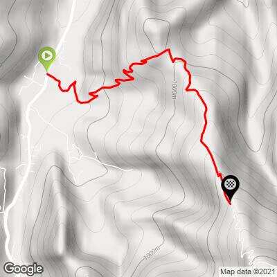
Pilone dell'Olocco climbs 4.4 km (2.7 mi) and gains 563 m (1,847 ft) at an average of 13.0%.
There's nothing gentle about it. Every kilometer averages more than 11%: roughly 12.5% for the first, 14.5% and 14.2% for the second and third as the lane switchbacks up to the Cappella dell'Olocco, then around 11% and 12.5% for the final stretch through the forest above the chapel.
The steepest kilometer averages 15.1% and the steepest 2 km (1.2 mi) 14.1%. The steepest 500 m (0.3 mi) averages 16.6%, and the steepest 100 m pitch reaches 18.3%.
Roadway: A narrow, single-lane asphalt road switchbacks from Vigna up to the Cappella dell'Olocco and continues paved through the forest above it. The climb ends where the lane meets the Strada di Mascarone, an unpaved forestry track - turn around there on a road bike. In winter the mayor of Chiusa di Pesio can close the road to vehicles by ordinance, and the shaded upper section can hold snow and ice, so this is a spring-to-autumn climb.
Traffic: Very light. The lane serves only a handful of hamlets and the chapel, so expect the occasional resident's car or hikers' vehicles heading to the trailheads around the Olocco - and take care on the steep, narrow descent.
Parking: Park in the Valle Pesio near Vigna, at the bottom of the climb, rather than driving the narrow lane. There are a few spaces beside the Cappella dell'Olocco, about halfway up, which hikers use as the starting point for the Giro delle Borgate loop.
Provisions: Stock up in Chiusa di Pesio on the way up the valley - there are no services on the climb. Tetti Fuggin, about 2 km in, has a fountain.
Gear: Gearing is everything here: more than 4 km at 13% with pitches near 18% calls for the lowest gear you can fit - a compact crank with a 34-tooth or larger cog, or a sub-compact setup, is a sensible minimum. Check your brakes and tires before the descent; the lane is steep, narrow and shaded.
Before heading out on any cycling adventure check out our Things to Bring on a Cycling Trip and use our interactive check list to ensure you don't forget anything.
Higher up the Valle Pesio from Vigna, the Certosa di Pesio is a Carthusian monastery founded in 1173 and extended over the following centuries, now home again to the Consolata Missionaries - a short ride up the valley road and a peaceful place to visit. The upper valley also leads into the Parco Naturale del Marguareis, with the Pis del Pesio at the river's source.
Back in Chiusa di Pesio, look for two local products: the chestnuts of Chiusa, from the valley's centuries-old chestnut groves, and Testun della Valle Pesio, a hard, raw-milk cheese. The neighboring Provinciale di Pradeboni starts close by - see other climbs nearby, or build a custom route from here, with our Routes in the Area tool.
ROUTE MAP
MEMBER RATING
CURRENT WEATHER
PJAMM TRIPS ADVENTURE STARTER BUNDLES
Check out PJAMM Adventure's prepackaged (self-guided) cycling trips. They will help you plan, document and conquer your next adventure.
NEARBY CLIMBS (0) RADIAL PROXIMITY
FROM No Climbs Found
MEMBER REVIEWS & COMMENTS
Let us know what you thought of this climb. Signup for our FREE membership to write a review or post a comment.
Already have an account?
LOG IN HERE
