
25.1
PDI
9.8 mi
DISTANCE
3,788 ft
GAINED
7.4 %
AVG. GRADE
FULL CLIMB STATS
INTRO
Colle di Ciabra climbs 15.75 km (9.8 mi) out of Rossana, in Piemonte's Provincia di Cuneo, gaining 1,155 m (3,788 ft) at a 7.4% average grade to a 1,700 m (5,577 ft) pass on the ridge dividing the Valle Varaita from the Valle Maira. This is a genuinely historic road: it's a paved stretch of the "Strada dei Cannoni" (Road of the Cannons), an 18th-century military route built under Charles Emmanuel III of Savoy to move artillery between Alpine fortifications.
From the hamlet of Lemma, about 6.4 km of good tarmac leads to the pass, where a fountain marks the summit. Beyond Ciabra, the historic road continues as an unpaved track toward Colle del Birrone and, eventually, the higher and better-known Colle di Sampeyre - a worthwhile extension for a gravel bike, though this climb itself stays fully paved.
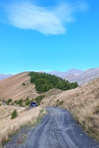
Since a municipal traffic bylaw took effect on July 14, 2025, motor vehicles are restricted to the road on Tuesdays and Thursdays only - the other five days a week, it's reserved for pedestrians and cyclists. Combined with genuinely light year-round traffic, that makes this one of the quieter historic climbs in the Cuneo Alps, with sweeping views toward Monviso and the Cottian Alps from the upper switchbacks.
PLAN YOUR ROUTE
 We've partnered with Sherpa-Map.com to bring you the best route planning tool. With a PRO Membership you can use this climb as a reference when creating your route.
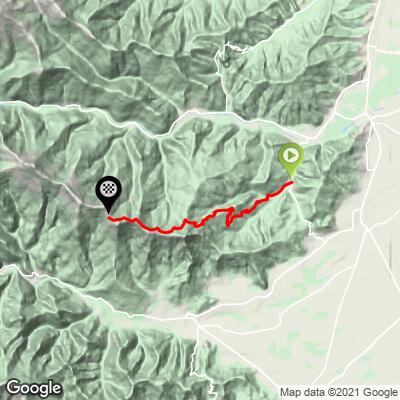
 From Rossana, Colle di Ciabra runs 15.75 km (9.8 mi) and gains 1155 m (3,788 ft) at an average grade of 7.4%. The road starts at 545 m (1,789 ft) and tops out at 1700 m (5,577 ft).
The lower kilometers out of Rossana are the mildest part of the climb, building gradually before the paved stretch from Lemma to the summit takes on a harder, more sustained character. The steepest kilometer averages 12.9%, and a 100-yard ramp touches 18.2% - keep a low gear in reserve for the upper switchbacks.
World rank: 550.
Roadway: The road is paved the entire way from Rossana to the pass, including the roughly 6.4 km stretch from Lemma to the summit. Surface quality is decent but not pristine - a few sections are somewhat uneven, consistent with a historic route that sees limited maintenance compared to a major provincial road. Beyond the pass, the road continues as an unpaved historic military track toward Colle del Birrone, but that section isn't part of this paved climb.
Traffic: Traffic is already light year-round, and since July 14, 2025, a municipal traffic bylaw has restricted motor vehicles on this historic road to Tuesdays and Thursdays only - the other five days a week it's reserved for pedestrians and cyclists, making this one of the quietest paved passes in the area most of the time.
Parking: Rossana is a small village with ordinary street parking near the town center; there's no dedicated trailhead lot since the climb starts right from town.
Rossana has limited services - a small shop or two for a basic stop, but nothing beyond Lemma partway up the climb. There's a fountain at the summit for a water refill before you head back down, but don't count on anything else once you leave town.
The steepest pitches near the top run into the double digits, so keep a low gear available even though the overall average is a manageable 7.4%. At 1,700 m the summit can be noticeably cooler and windier than Rossana, so pack a light layer for the descent.
Before heading out on any cycling adventure check out our Things to Bring on a Cycling Trip and use our interactive check list to ensure you don't forget anything.
This climb is a paved sampler of the much longer "Strada dei Cannoni," a historic 18th-century military road that runs roughly 40 km in total from Rossana all the way to Colle della Bicocca, largely unpaved beyond this pass. Riders on a gravel or mountain bike can continue past Ciabra toward Colle del Birrone and eventually reach Colle di Sampeyre, a more famous pass on the same ridge that's typically climbed from the town of Sampeyre on the other side of the valley - worth knowing about if you want to extend the day, though it's a different kind of ride once the pavement ends.
Rossana itself is a quiet base rather than a resort town, so plan meals and lodging with that in mind - Cuneo and the larger towns of the Valle Varaita have fuller services if you need them.
ROUTE MAP
MEMBER RATING
CURRENT WEATHER
PJAMM TRIPS ADVENTURE STARTER BUNDLES
Check out PJAMM Adventure's prepackaged (self-guided) cycling trips. They will help you plan, document and conquer your next adventure.
NEARBY CLIMBS (0) RADIAL PROXIMITY
FROM No Climbs Found
MEMBER REVIEWS & COMMENTS
Let us know what you thought of this climb. Signup for our FREE membership to write a review or post a comment.
Already have an account?
LOG IN HERE
