
16
PDI
5.8 mi
DISTANCE
2,362 ft
GAINED
7.7 %
AVG. GRADE
FULL CLIMB STATS
INTRO
In August 1834 four shepherd girls from Valmala, aged 10 to 12, said the Virgin had appeared to them on this wooded shoulder above the Valle Varaita. A pylon went up on the spot, then a chapel in 1840 and the sanctuary in 1851. Today a narrow strip of tarmac climbs to it through broadleaf woods, and it's one of the quietest climbs in the valley.
The climb is 9.3 km (5.8 mi) from Valcurta on the valley floor, with 720 m (2362 ft) of gain at 7.7%. The first kilometer is the only easy one. From there it's 6.5-8% up to the village of Valmala at km 3, and just above the houses comes the hardest stretch, between km 3.5 and 4.5 - a full kilometer at 10%. There's a short breather around km 5-6 at about 5%, and then the last 3.3 km go back to 8-9.6% all the way to the top.
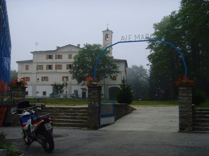
The road ends on a broad square at about 1360 m (4462 ft), with a statue on a small roundabout, the sanctuary buildings and the church with its bell tower. Footpaths lead on to Monte San Bernardo and along the ridge to Monte Cornet, which looks straight across at Monviso - if you've brought walking shoes, that's the reason to stay a while.
PLAN YOUR ROUTE
 We've partnered with Sherpa-Map.com to bring you the best route planning tool. With a PRO Membership you can use this climb as a reference when creating your route.
Valcurta to Valmala (km 0-3): An easy first kilometer (4.6%), then 7.8% and about 6.5% up to Valmala village.
Above the village (km 3-5): The toughest part of the climb - km 3 to 5 average 9-10%, and the steepest 500 m reach 10.7%.
The breather (km 5-6): About 5%, the only real easing.
To the sanctuary (km 6-9.3): Back to 8-9.6% through the woods, with no let-up before the square.
Climb stats: 9.3 km (5.8 mi), 720 m (2362 ft) of gain, 7.7% average.
Roadway: There's tarmac to the top, but it's narrow - for long stretches the SP109 is barely wider than one car, and the chip-seal surface is rough and patched in places, with grass growing along the edges. Ride the descent with care, as the road twists through the trees. The top is at about 1360 m, so expect snow and ice there in winter.
Traffic: Light - mostly residents, visitors to the sanctuary and walkers heading for the trails above it.
Parking: There's parking by the sanctuary square at the top, which makes a car-assisted one-way ride easy. At the bottom, look for space along the valley road at Valcurta or in Melle, just up the Valle Varaita.
Gear: Most of the climb sits at 8-10%, so fit the biggest cassette you own - a 32 or 34 at the back makes it far more pleasant. Bring a layer for the descent - you'll be some 700 m above the valley floor.
Provisions: Stock up in the Valle Varaita before you turn off - two bottles will see you to the top and back.
Before heading out on any cycling adventure check out our Things to Bring on a Cycling Trip and use our interactive check list to ensure you don't forget anything.
The Valle Varaita is one of Piemonte's Occitan valleys, and it's fine riding country. Valmala sits between two of its bigger climbs: the Colle di Ciabra, reached from Rossana on the old Strada dei Cannoni, and the Colle di Sampeyre further up the valley. Saluzzo, at the mouth of the valley, is the nearest proper town, with a hilltop old quarter and plenty of places to stay and eat, and Cuneo is about 25 km away.
Valmala has been part of the comune of Busca since 2019, which is why some maps and signs list the sanctuary under Busca. For a longer day, open Routes in the Area to see how Valmala links with the Ciabra, the Passo della Piata and the Fauniera.
ROUTE MAP

MEMBER RATING
CURRENT WEATHER
PJAMM TRIPS ADVENTURE STARTER BUNDLES
Check out PJAMM Adventure's prepackaged (self-guided) cycling trips. They will help you plan, document and conquer your next adventure.
NEARBY CLIMBS (0) RADIAL PROXIMITY
FROM No Climbs Found
MEMBER REVIEWS & COMMENTS
Let us know what you thought of this climb. Signup for our FREE membership to write a review or post a comment.
Already have an account?
LOG IN HERE
