
25.7
PDI
9.5 mi
DISTANCE
3,823 ft
GAINED
7.6 %
AVG. GRADE
FULL CLIMB STATS
INTRO
Montoso climbs 15.2 km (9.5 mi) out of Bagnolo Piemonte in the Cottian Alps foothills below Monviso, gaining 1,165 m (3,823 ft) at a 7.6% average grade on the way to Rucas at 1,526 m (5,007 ft). The road up from Bagnolo runs through nine hairpins and stays open year-round, unlike the secondary approach from Bibiana, which closes for winter.
What sets Montoso apart is how uneven its grade is - roughly 6 km of the climb sit between 10% and 15%, with the steepest kilometer averaging 11.8% on a road that's often narrow and rough underfoot on the way up. (The descent toward Bagnolo, by contrast, is smooth, fast tarmac with sweeping bends.) The mountain has real wartime history too - its forests sheltered Italian partisan resistance activity during the Second World War.
Montoso is a recent addition to professional racing: the Giro d'Italia included it for the first time in 2019, on a stage built around the 100th anniversary of Fausto Coppi's birth and his legendary 1949 Cuneo-Pinerolo win. It returns in 2026 as the decisive final-stage climb of the Giro d'Italia Women, finishing in Saluzzo.
PLAN YOUR ROUTE
 We've partnered with Sherpa-Map.com to bring you the best route planning tool. With a PRO Membership you can use this climb as a reference when creating your route.
 Montoso gains 1,165 m (3,823 ft) over 15.2 km (9.5 mi) at a 7.6% average grade, finishing near Rucas at 1,526 m (5,007 ft). The steepest kilometer averages 11.8% and the steepest mile 11.3%, but the defining feature is how much of the middle section holds double-digit grades rather than one isolated ramp - riders should expect long stretches in the 10-15% range with little recovery between them, not just a short, sharp pitch.
Roadway: The road from Bagnolo Piemonte is paved the entire way and stays open year-round, but the surface on the way up is narrower and rougher than most Piedmont climbs - budget for a bumpier ride, especially through the switchbacked middle section. The descent back toward Bagnolo, on the alternate side of the loop, is smoother, fresher tarmac with wide sweeping bends.
Traffic: Light. This is a quiet mountain road with little through-traffic beyond local residents and the occasional cyclist - most vehicle traffic thins out quickly once you clear the edge of Bagnolo.
Parking: Free parking is available in and around the center of Bagnolo Piemonte, close to where the climb begins. There's no dedicated cyclist parking area higher up, so plan to start from town rather than driving partway up the mountain.
Bring low gearing - a compact or sub-compact crank with a wide-range cassette makes a real difference on the sustained 10-15% sections through the middle of the climb, where there's little chance to recover. The road is fully paved, so a standard road bike is fine; wider tires help smooth out the rougher patches on the way up. Bagnolo Piemonte has shops and cafes for stocking up before you start, but there's nothing reliable once you leave town, so carry enough water and food for the full 15.2 km (9.5 mi) to Rucas.
Before heading out on any cycling adventure check out our Things to Bring on a Cycling Trip and use our interactive check list to ensure you don't forget anything.
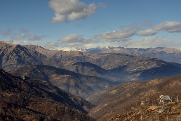
Bagnolo Piemonte sits at the base of the Cottian Alps with views toward Monviso, the source of the Po river and one of the most recognizable peaks in the western Alps - worth a look before you start climbing. The town itself is a quiet, workaday base rather than a resort, so keep pre-ride logistics simple: fuel up in town and head straight for the mountain.
Montoso's place in cycling history is recent but real - it debuted in the Giro d'Italia in 2019 on a stage built around Fausto Coppi's centennial, and returns as the decisive final climb of the 2026 Giro d'Italia Women. See other climbs in the area, including the alternate descent route toward Bibiana, with our Routes in the Area tool.
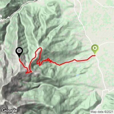
ROUTE MAP
MEMBER RATING
CURRENT WEATHER
PJAMM TRIPS ADVENTURE STARTER BUNDLES
Check out PJAMM Adventure's prepackaged (self-guided) cycling trips. They will help you plan, document and conquer your next adventure.
NEARBY CLIMBS (0) RADIAL PROXIMITY
FROM No Climbs Found
MEMBER REVIEWS & COMMENTS
Let us know what you thought of this climb. Signup for our FREE membership to write a review or post a comment.
Already have an account?
LOG IN HERE
