
23
PDI
9.8 mi
DISTANCE
3,585 ft
GAINED
7 %
AVG. GRADE
FULL CLIMB STATS
INTRO
Saint Pierre-Vétan climbs from the village of Saint-Pierre (687 m / 2,254 ft) in Italy's Valle d'Aosta up to the hamlet of Vétan at 1,780 m (5,839 ft), covering 15.7 km (9.8 mi) and gaining 1,093 m (3,585 ft) at a 7.0% average grade.
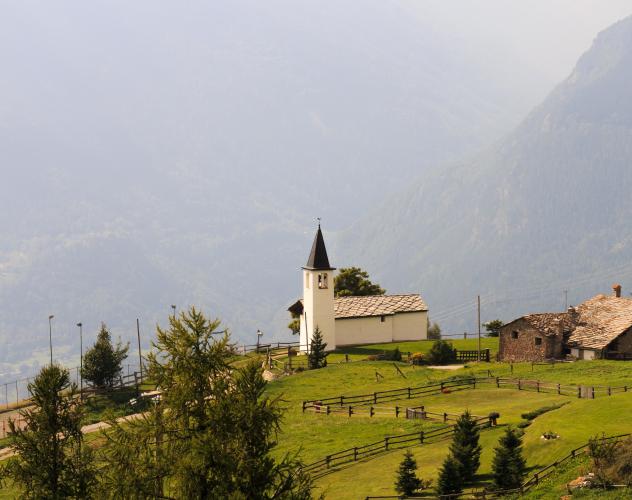
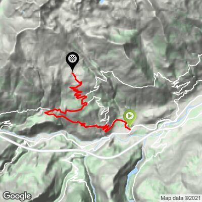
The route switchbacks through roughly 22 hairpins, passing through the village of Saint-Nicolas - with a small cobblestoned center about halfway up - before continuing past the hamlets of Petit Sarriod and Gerbore to Vétan. Riding south-facing the entire way, the climb is unusually open for an Alpine ascent, with panoramas from the first pedal stroke that build from sheer valley-floor views to broad high pastures with the Gran Paradiso and Rutor glaciers visible across the valley.
Saint-Pierre itself is anchored by the Saint-Pierre Castle, a turreted 12th-century fortress rebuilt in the 1870s that now houses the Aosta Valley's Regional Museum of Natural Sciences - worth a look before or after the ride.
PLAN YOUR ROUTE
 We've partnered with Sherpa-Map.com to bring you the best route planning tool. With a PRO Membership you can use this climb as a reference when creating your route.
 From Saint-Pierre (687 m / 2,254 ft) to Vétan (1,780 m / 5,839 ft), the climb covers 15.7 km (9.8 mi) and gains 1,093 m (3,585 ft) at a 7.0% average grade.
The grade stays fairly even for a climb this long - the steepest continuous 10 km still only averages 7.3% - but has real bite in shorter bursts, with the steepest quarter mile averaging 10.7% and the steepest 100 yards reaching 12.4%. Expect a steady rhythm through the hairpins rather than sharp pitches.
Roadway: Paved the entire way on the SR22 and SR41, with grades described by riders as substantially regular rather than punchy. Because the route is south-facing and largely open, it gets full sun for most of the day - a plus for early-season riding, but worth avoiding during the hottest midday hours in summer.
Traffic: Very light. This is a quiet regional road serving a handful of small villages and hamlets, not a through-route, and riders consistently describe it as essentially traffic-free.
Parking: Saint-Pierre village center, near the base of the Saint-Pierre Castle, is the practical starting point - ordinary street parking is available around the village.
Because the climb is south-facing and largely unshaded, carry more water and sun protection than you would on a typical tree-covered Alpine ascent, especially outside the early morning hours. Saint-Nicolas, roughly the halfway point, is the last reliable spot for water before Vétan - stock up there or in Saint-Pierre before starting.
The steady mid-grade climbing suits a standard alpine gearing setup; nothing on this route demands the very low gearing some of the steeper Valle d'Aosta climbs require.
Before heading out on any cycling adventure check out our Things to Bring on a Cycling Trip and use our interactive check list to ensure you don't forget anything.
Aosta, the regional capital, is a short drive from Saint-Pierre and makes a practical base with a fuller range of hotels and restaurants, plus rail access into the rest of the valley.
Before or after the ride, the Saint-Pierre Castle at the base of the climb is worth the stop - the 12th-century fortress, rebuilt in the 1870s, now houses the Aosta Valley's Regional Museum of Natural Sciences.
The broad views toward the Gran Paradiso massif partway up are a highlight - Gran Paradiso National Park, Italy's oldest national park, lies just across the valley and is worth a visit of its own if you have extra time in the area.
ROUTE MAP
MEMBER RATING
CURRENT WEATHER
PJAMM TRIPS ADVENTURE STARTER BUNDLES
Check out PJAMM Adventure's prepackaged (self-guided) cycling trips. They will help you plan, document and conquer your next adventure.
NEARBY CLIMBS (0) RADIAL PROXIMITY
FROM No Climbs Found
MEMBER REVIEWS & COMMENTS
Let us know what you thought of this climb. Signup for our FREE membership to write a review or post a comment.
Already have an account?
LOG IN HERE
