37.5
PDI
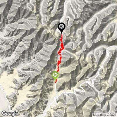
14.8 mi
DISTANCE
4,426 ft
GAINED
5.6 %
AVG. GRADE
FULL CLIMB STATS
INTRO
This 14.8 mile bike climb is located in India. The average gradient is 5.6% and there is a total elevation gain of 4,426 ft, finishing at 17,335 ft.
Use the profile tool, route map, and weather forecast to conquer this cycling climb.
Use the profile tool, route map, and weather forecast to conquer this cycling climb.
PLAN YOUR ROUTE
This climb averages 0%. The steepest quarter mile of this climb is 0%. NaN miles of the climb is at or above 10% grade. The gradient on this climb is broken down as follows:
See more details and tools regarding this climb's grade via our interactive Profile Tool.
See more details and tools regarding this climb's grade via our interactive Profile Tool.
Information Not Available
If you have any information regarding this climb, we'd like to hear from you. Click the CONTRIBUTE button to share your thoughts with us.
Information Not Available
If you have any information regarding this climb, we'd like to hear from you. Click the CONTRIBUTE button to share your thoughts with us.
Before heading out on any cycling adventure check out our Things to Bring on a Cycling Trip and use our interactive check list to ensure you don't forget anything.
Information Not Available
If you have any information regarding this climb, we'd like to hear from you. Click the CONTRIBUTE button to share your thoughts with us.
ROUTE MAP
MEMBER RATING
CURRENT WEATHER
PJAMM TRIPS ADVENTURE STARTER BUNDLES
Check out PJAMM Adventure's prepackaged (self-guided) cycling trips. They will help you plan, document and conquer your next adventure.
NEARBY CLIMBS (0) RADIAL PROXIMITY
FROM No Climbs Found
MEMBER REVIEWS & COMMENTS
Let us know what you thought of this climb. Signup for our FREE membership to write a review or post a comment.
Already have an account?
LOG IN HERE
dioelle
17.5K Himalayan pass. What else needs to be said? Crossed 2016 N to S, 2019 S to N but only the last 10K uphill. Huge terrain; stunning views of the tail end of the Karakoram range to the north with peaks > 7,000 meters. S side is a little more monotonous and just huge. Very light traffic esp. compared to Khardung la. The villages and temples on either side are very interesting also.