
25.1
PDI
7.1 mi
DISTANCE
3,314 ft
GAINED
8.9 %
AVG. GRADE
FULL CLIMB STATS
INTRO
Champremier is a demanding climb above Fénis in Italy's Valle d'Aosta, rising through the Vallone del Pillier to a hamlet at 1,586 m (5,204 ft). From Fénis it runs 11.4 km (7.1 mi) and gains 1,010 m (3,314 ft) at an average grade of 8.9% - one of the steeper sustained climbs in a region full of them, with the hardest kilometer averaging 12.9% and a brief 100-yard ramp spiking to 24.4%.
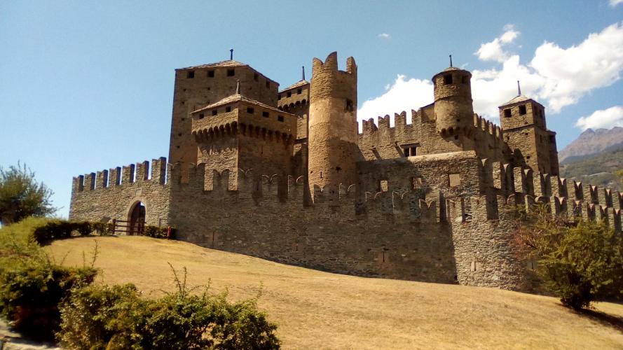
The road climbs out of Fénis past its famous medieval castle, one of the best-preserved in the Alps, then switches into the forested Pillier valley on a quiet, fully paved road with essentially no through-traffic - it dead-ends at Champremier rather than connecting anywhere else.
The climb is difficult and obscure enough to have been used as a categorized ascent in the Giro Valle d'Aosta, the well-regarded U23 stage race that regularly draws future WorldTour riders.
There's no services once you leave Fénis, and no flat sections to recover on - this is a steady, unrelenting grade the whole way up. The payoff is real solitude and, from the upper switchbacks, open views back across the Aosta Valley toward the Gran Paradiso range.
PLAN YOUR ROUTE
 We've partnered with Sherpa-Map.com to bring you the best route planning tool. With a PRO Membership you can use this climb as a reference when creating your route.
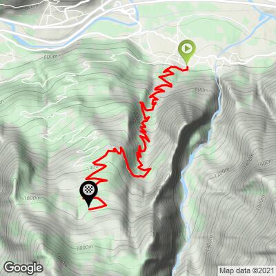
 From Fénis, Champremier runs 11.4 km (7.1 mi) and gains 1,010 m (3,314 ft) at an average grade of 8.9%. The road starts at 576 m (1,890 ft) and finishes at 1,586 m (5,204 ft).
This is a steep climb with no real recovery sections - the grade holds in the high single digits to low double digits almost the entire way. The steepest kilometer averages 12.9%, and there's a brief 100-yard ramp that spikes to 24.4%, so keep a low gear in reserve for the switchbacks in the upper Pillier valley.
World rank: 544.
Roadway: The road is paved the entire way from Fénis to Champremier. It's a narrow valley road rather than a major route, but the surface itself is in decent shape - local mountain-bike route notes describe it as fully asphalted on the ascent, with only a short unpaved section appearing on an alternate return route well past Champremier itself, not on the way up.
Traffic: Traffic is very light. The road serves only the hamlets in the Vallone del Pillier and dead-ends at Champremier rather than connecting through to another valley, so there's no through-traffic - just the occasional local vehicle or farm equipment.
Parking: Fénis is a small town built around its well-known medieval castle, with ordinary street parking available near the castle and town center. There's no dedicated climb trailhead - riders typically start from the town center or the castle parking area before heading up toward the Vallone del Pillier.
Fénis has a small selection of shops, bars, and B&Bs for a pre-ride coffee or last bottle fill, but there's nothing at all once you leave town - no cafe, fountain, or shop along the climb itself, so carry what you'll need for the full ascent and descent.
Given the sustained 8-9% grade with double-digit ramps, a compact or triple crankset with a wide-range cassette is worth having over a standard setup. There's no flat recovery section to shift around on, so gearing choice matters more here than on a typical Alpine col.
Before heading out on any cycling adventure check out our Things to Bring on a Cycling Trip and use our interactive check list to ensure you don't forget anything.
Fénis is worth arriving early for regardless of the climb - its 13th-century castle is one of the best-preserved and most-visited in the Aosta Valley, with a distinctive double ring of walls and towers that's very different from the more austere fortresses elsewhere in the region. It's a short walk from the town center and makes a natural pre- or post-ride stop.
Beyond the castle, Fénis itself is a quiet base rather than a resort town, so plan meals and lodging with that in mind - Aosta, about 20 minutes away by car, has a fuller range of restaurants and bike shops if you need them.
For a look at what else is worth riding nearby in the valley, our Routes in the Area tool is a useful starting point.
ROUTE MAP
MEMBER RATING
CURRENT WEATHER
PJAMM TRIPS ADVENTURE STARTER BUNDLES
Check out PJAMM Adventure's prepackaged (self-guided) cycling trips. They will help you plan, document and conquer your next adventure.
NEARBY CLIMBS (0) RADIAL PROXIMITY
FROM No Climbs Found
MEMBER REVIEWS & COMMENTS
Let us know what you thought of this climb. Signup for our FREE membership to write a review or post a comment.
Already have an account?
LOG IN HERE
