
25.2
PDI
10.2 mi
DISTANCE
3,879 ft
GAINED
7.2 %
AVG. GRADE
FULL CLIMB STATS
INTRO
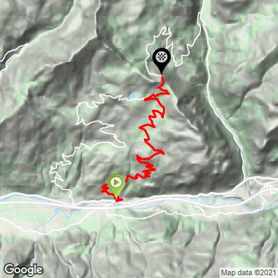
Colle di San Pantaleone climbs out of Chambave, a small wine-growing village in the central Aosta Valley, on a quiet regional road most Italian cyclists know as the Col Saint-Pantaléon. From the village the route covers 16.5 km (10.2 mi) and gains 1,182.3 m (3,879 ft) at a 7.2% average grade over 27 switchbacks, topping out at 1,665.4 m (5,464 ft).
The climb changes character three times on the way up. It starts hard, climbing steeply out of Chambave's vineyards past Saint-Denis and the ruined Château de Cly; eases through a flatter, more open stretch across the meadows of Petit Bruson; then steepens again through forest for a final push that averages close to 10% into the last kilometer. From a viewpoint just below the true summit, the Matterhorn appears on the horizon across the Valtournenche - a payoff few riders expect from such an obscure pass.
Despite carrying a difficulty rating that climb-tracking sites rate comparable to the Col du Galibier from Valloire, Colle di San Pantaleone remains little-known outside Italy - it wasn't until Stage 19 of the 2025 Giro d'Italia (Biella to Champoluc) that the race first climbed it, cresting at 1,664 m on the way to the Col di Joux and the stage finish in Champoluc. The road was freshly resurfaced for that race and remains in excellent condition.
PLAN YOUR ROUTE
 We've partnered with Sherpa-Map.com to bring you the best route planning tool. With a PRO Membership you can use this climb as a reference when creating your route.
 The overall 7.2% average blends three distinct sections. The push out of Chambave is the steepest sustained stretch, with the opening half-kilometer averaging 10.4% and the steepest 100 yards reaching 10.9%. A genuinely flatter section across the Petit Bruson meadows around the midpoint offers real recovery - something this climb has that many comparable Aosta Valley passes don't - before the final kilometers through the forest push back up to around 10% on the way to the pass.
Reviewers on European climb-tracking sites have informally rated this climb's difficulty as comparable to the Col du Galibier from Valloire, despite far less name recognition. The finish is also easy to miss - a small panoramic overlook rather than a marked summit sign - so don't expect an obvious "top" to sprint for.
Roadway: The road (Strada Regionale 12 through Saint-Denis, then Strada Regionale 42, signed Col Saint-Pantaléon, to the pass) is paved the entire way and was freshly resurfaced ahead of the 2025 Giro d'Italia, which climbed it on Stage 19. Rider reports consistently rate the surface as good throughout.
Traffic: Traffic is light throughout - most riders describe it as one of the quieter climbs in the Aosta Valley, with early rides seeing almost no cars. There's no major tourist destination at the summit to draw day-trip traffic, unlike some neighboring passes.
Parking: There's no dedicated cycling lot; most riders park in Chambave itself, near the village center or the La Crotta di Vegneron winery at the base of the climb, and start from there.
Chambave has a few small shops and cafes for a final top-off before you start - there's nothing else until the pass itself, which has no services at all, just a small viewpoint. Carry enough water and food for a genuinely uninterrupted 1.5-2 hour effort.
A compact setup with a wide-range cassette suits this climb well - the steep opening kilometers out of Chambave and the steep final kilometer through the forest both call for a genuinely easy low gear, even though the middle section across Petit Bruson gives real relief. Standard road tires are fine; the surface was freshly repaved for the 2025 Giro d'Italia and remains in good condition throughout.
Before heading out on any cycling adventure check out our Things to Bring on a Cycling Trip and use our interactive check list to ensure you don't forget anything.
Chambave is a small wine village known for Chambave Muscat, a DOC white wine made from aromatic moscato grapes grown on the valley's steep, sun-exposed terraces. La Crotta di Vegneron, a cooperative winery founded in 1980, has a cantina in the village where you can taste and buy bottles before or after the ride.
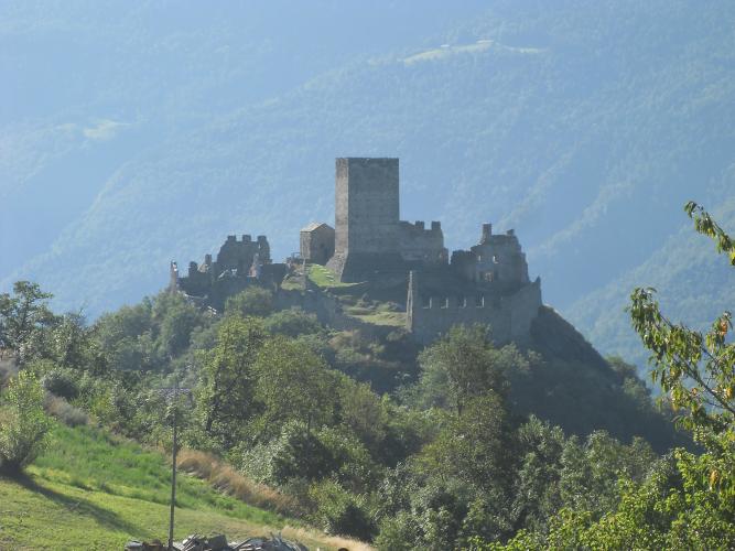
The road runs directly below the ruins of the Château de Cly at Saint-Denis, a medieval fortress with commanding views over the valley - worth a quick look even mid-climb, since the route passes right by it. Riders wanting to see more of the area can also descend the far side toward Antey-Saint-André, where a second, slightly different approach to the same pass exists.
See our Routes in the Area tool for other Aosta Valley climbs nearby, including a handful in the Châtillon and Antey-Saint-André area.
ROUTE MAP
MEMBER RATING
CURRENT WEATHER
PJAMM TRIPS ADVENTURE STARTER BUNDLES
Check out PJAMM Adventure's prepackaged (self-guided) cycling trips. They will help you plan, document and conquer your next adventure.
NEARBY CLIMBS (0) RADIAL PROXIMITY
FROM No Climbs Found
MEMBER REVIEWS & COMMENTS
Let us know what you thought of this climb. Signup for our FREE membership to write a review or post a comment.
Already have an account?
LOG IN HERE
