
19.5
PDI
7.1 mi
DISTANCE
2,823 ft
GAINED
7.6 %
AVG. GRADE
FULL CLIMB STATS
INTRO
PLAN YOUR ROUTE
 We've partnered with Sherpa-Map.com to bring you the best route planning tool. With a PRO Membership you can use this climb as a reference when creating your route.
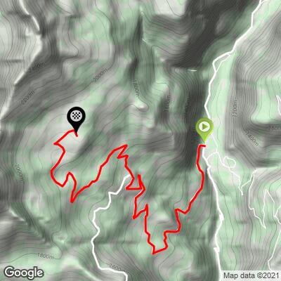
The Cronoscalata Antey-Torgnon averages 7.6% over 11.4 km (7.1 mi), gaining 860.5 m (2,823 ft) from 1,030 m (3,380 ft) to 1,889 m (6,198 ft).
The steepest 100 yards (91 m) reach 12.2%, the steepest 500 m averages 10.9%, the steepest kilometer 10.3% and the steepest 5 km 8.6%. The steepest 10 km still averages 7.7%, which tells you how little recovery the road offers.
Roadway: The road is paved the entire way, climbing from the valley floor at Antey-Saint-André through the scattered hamlets of Torgnon. Above the village the tarmac continues toward the Chantorné meadows, where the cross-country ski track and picnic area are signed from Torgnon.
Traffic: Traffic is mostly local, plus visitors heading to Torgnon's cable car, ski lifts, trails and cross-country track, so the most cars come on ski-season weekends. The road ends in the meadows above the village rather than serving as a through route, so there is no heavy through traffic.
Parking: Antey-Saint-André is a small village of about 540 residents rather than a resort, and the climb starts from the valley road just below it. If you arrive by rail, Châtillon-Saint-Vincent station is about 7.5 km (4.7 mi) down the valley, an easy spin to the start. Higher up, the Chantorné area has a signed picnic area and a small plateau with a white chapel beside the tarmac road, handy for meeting a support car.
Gear: Choose gearing that lets you keep spinning on 10-11% pitches, such as a compact crankset with a wide-range cassette. The finish is close to 1,900 m (6,200 ft), so bring a light jacket for the descent back to Antey.
Provisions: Torgnon is a ski village with restaurants serving traditional Valle d'Aosta recipes, so there are places to stop partway up or after the ride. Carry water for the climb itself.
Before heading out on any cycling adventure check out our Things to Bring on a Cycling Trip and use our interactive check list to ensure you don't forget anything.
Torgnon is worth lingering in. Its villages are strung across the mountainside rather than clustered, the parish is cited in a papal bull of 1176, and locals still play the traditional games of palet and tsan. In winter the Mongnod-Chantorné cable car climbs to a ski area with roughly 25 km of pistes, and in summer the paths from Torgnon lead to alpine pastures and ponds such as Lo Ditor.
For a viewpoint, the sanctuary of Gilliarey (2,187 m / 7,175 ft) looks down the Valtournenche toward Châtillon and the Matterhorn, and path 14 climbs from Antey (1,074 m / 3,524 ft) to the chapel of Saint-Évence at 1,650 m (5,413 ft), another Cervino balcony. Torgnon's family hotels, such as the Hotel Zerbion, make a comfortable base for riding the valley.
The neighboring Colle di San Pantaleone and Cheneil climbs have their own pages, covering the Chambave wine villages on the far side of the pass and the Cheneil inclined lift up the valley, so we keep the focus here on Torgnon.
ROUTE MAP
MEMBER RATING
CURRENT WEATHER
PJAMM TRIPS ADVENTURE STARTER BUNDLES
Check out PJAMM Adventure's prepackaged (self-guided) cycling trips. They will help you plan, document and conquer your next adventure.
NEARBY CLIMBS (0) RADIAL PROXIMITY
FROM No Climbs Found
MEMBER REVIEWS & COMMENTS
Let us know what you thought of this climb. Signup for our FREE membership to write a review or post a comment.
Already have an account?
LOG IN HERE
