
30.3
PDI
16.3 mi
DISTANCE
5,158 ft
GAINED
6 %
AVG. GRADE
FULL CLIMB STATS
INTRO
PLAN YOUR ROUTE
 We've partnered with Sherpa-Map.com to bring you the best route planning tool. With a PRO Membership you can use this climb as a reference when creating your route.
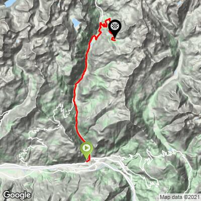
 This climb averages 6.0% over 16.3 miles, but the grade is far from even across such a long valley road. The lower miles from Châtillon through Antey-Saint-André are the gentlest part of the climb, generally in the 3-5% range as the road follows the valley floor. The grade picks up noticeably from Valtournenche onward, and the final stretch up to La Barma - the last several miles of the climb - is the toughest section, averaging around 7% with pitches reported near 12% as the road works its way up into the higher basin below Cheneil.
Roadway: Paved and in very good condition the entire way - this is a well-maintained regional road serving the Valtournenche valley and the Breuil-Cervinia ski resort, not a rough back road.
Traffic: Fairly present in the lower valley, where the road doubles as the main access route to Cervinia and carries real tourist and local traffic, especially in ski season and summer. Traffic thins out above Valtournenche, and the final miles up to La Barma are noticeably quieter.
Parking: Châtillon, at the base of the climb, has street parking in town and a train station on the Turin-Aosta line. At the top of the climb, La Barma has a large public parking area (built to serve the inclined lift up to Cheneil) - useful if you're organizing a return shuttle or want to see where car access for this valley actually ends.
Standard gearing is fine for most of this climb given the moderate lower-valley grades, but bring a compact crank or a wide-range cassette for comfort on the steeper final miles above Valtournenche, where the road averages around 7% with pitches near 12%. Antey-Saint-André and Valtournenche both have shops, cafes, and restaurants, so you don't need to carry a full day's provisions from the start - just make sure to fill bottles in Valtournenche, since there's nothing at La Barma or above besides the lift station.
Before heading out on any cycling adventure check out our Things to Bring on a Cycling Trip and use our interactive check list to ensure you don't forget anything.
Châtillon makes a practical base, with a train station on the Turin-Aosta line and its own small castle (Castello Gamba) worth a look if you have time before or after the ride. Antey-Saint-André and Valtournenche, both roughly midway up the climb, are real mountain towns with places to eat and stay if you'd rather split this into a shorter ride with a night in the valley.
At the top, La Barma is the end of the road for cars and bikes alike - from there, a free public inclined lift (opened 2016) carries visitors the last 50 meters up to Cheneil itself, a tiny, car-free hamlet of stone-and-wood alpine huts with some of the best close-up Matterhorn views in the valley. It's worth locking up the bike and riding the lift up if you have the time. Check current conditions before you go with our Weather tool, since the finish sits close to 2,000 meters.
ROUTE MAP
MEMBER RATING
CURRENT WEATHER
PJAMM TRIPS ADVENTURE STARTER BUNDLES
Check out PJAMM Adventure's prepackaged (self-guided) cycling trips. They will help you plan, document and conquer your next adventure.
NEARBY CLIMBS (0) RADIAL PROXIMITY
FROM No Climbs Found
MEMBER REVIEWS & COMMENTS
Let us know what you thought of this climb. Signup for our FREE membership to write a review or post a comment.
Already have an account?
LOG IN HERE
