
17.9
PDI
6.2 mi
DISTANCE
2,621 ft
GAINED
8 %
AVG. GRADE
FULL CLIMB STATS
INTRO
PLAN YOUR ROUTE
 We've partnered with Sherpa-Map.com to bring you the best route planning tool. With a PRO Membership you can use this climb as a reference when creating your route.
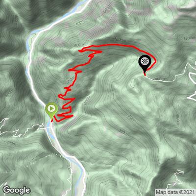
Passo di Glevizza climbs 10.0 km (6.2 mi) and gains 799 m (2621 ft) at an 8.0% average grade, from 190 m (625 ft) at the Natisone to 989 m (3245 ft) at the pass.
The steepest sections:
- Steepest 500 m (0.3 mi): 11.5%
- Steepest 1 km (0.6 mi): 11.0%
- Steepest 2 km (1.2 mi): 10.3%
- Steepest 5 km (3.1 mi): 9.6%
The profile is front-loaded. Kilometer by kilometer the grades run roughly 7.5%, 8.5%, 11.0%, 9.1%, 9.3%, 10.0%, 7.6%, 3.7%, 7.8% and 5.8% - so the first 6 km carry most of the climbing at about 9.2%, the eighth kilometer is a welcome breather, and the last 2 km are moderate.
Roadway: Paved the entire way. Once it leaves the SS54, the road narrows to a single lane through forest, with grassy verges and low walls in places and room for one car at a time, so be ready to pull in when you meet one. Google's 2024 imagery shows the surface in reasonable shape through the lower and middle sections. The upper road sits close to 1000 m (3300 ft) and can see snow and ice in winter.
Traffic: Very light. Above the valley the road serves only scattered houses and hamlets on the mountainside. The SS54 at the start is the main road up the valley toward the Slovenian border and carries steady traffic, but you are only on it briefly.
Parking: Pulfero village, about 1 km south of the start on the SS54, is the natural place to leave a car and roll up the flat valley road to the base of the climb. If you're riding this together with Matajur or Kolovrat, note that those climbs start from Savogna, in the neighboring Alberone valley to the southeast.
Gear: With nearly 6 km at 9-11% right from the start, a compact crankset with a 30- or 32-tooth cog is a good match. Bring a wind layer - the descent is shaded and drops 800 m (2600 ft) back to the river.
Provisions: Fill your bottles and eat in the valley before you start. There are no services on the climb or at the pass, and Montemaggiore beyond is a small village where you shouldn't count on anything being open.
Before heading out on any cycling adventure check out our Things to Bring on a Cycling Trip and use our interactive check list to ensure you don't forget anything.
Pulfero (Podbuniesac in Slovene) is home to the Grotta di San Giovanni d'Antro, about 3.5 km south of the start and the best off-the-bike stop in the valley. The cave opens in the cliff above the Natisone and has been a place of worship since at least the 8th century; you reach it by a long stone staircase through a fortified gate, and inside is a chapel with an 18th-century Slovene-style wooden altar holding 16th-century statues. The cave itself can be visited for several hundred meters - visits are run by the local Tarcetta association, so contact them before you go.
The Pulfero hamlets keep the Natisone Valleys' old customs alive: Kries bonfires on 6 January at Biacis and 23 June at Cicigolis, and Carnival masks in Montefosca, Mersino and Rodda. For the valleys' Slovene heritage, gubana and the SMO museum, see our Cima Kolovrat (Savogna) page, and for Cividale del Friuli see Matajur (da Ieronizza). See other climbs nearby, or build a custom route from here, with our Routes in the Area tool.
ROUTE MAP
MEMBER RATING
CURRENT WEATHER
PJAMM TRIPS ADVENTURE STARTER BUNDLES
Check out PJAMM Adventure's prepackaged (self-guided) cycling trips. They will help you plan, document and conquer your next adventure.
NEARBY CLIMBS (0) RADIAL PROXIMITY
FROM No Climbs Found
MEMBER REVIEWS & COMMENTS
Let us know what you thought of this climb. Signup for our FREE membership to write a review or post a comment.
Already have an account?
LOG IN HERE
