
20.5
PDI
7.5 mi
DISTANCE
3,019 ft
GAINED
7.7 %
AVG. GRADE
FULL CLIMB STATS
INTRO
PLAN YOUR ROUTE
 We've partnered with Sherpa-Map.com to bring you the best route planning tool. With a PRO Membership you can use this climb as a reference when creating your route.
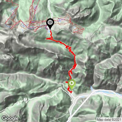
Pontebba to the pass is 12.0 km (7.5 mi) at a 7.7% average, with 920 m (3,019 ft) of gain. The first kilometer opens at 8.4%, followed by a brief easing to 5.1%, and then the climb settles into a long run of 8-9.7%: 8.4% at 3-4 km, 9.0% at 4-6 km, 9.7% at 6-7 km, and 8.2%, 7.1% and 8.6% after that.
The last two kilometers are the gentlest at 5.9% and 6.6%. The steepest 1 km averages 9.7%, the steepest 2 km 9.5%, the steepest 5 km 9.0% and the steepest 10 km 8.0%. The steepest 100 m reaches 11.9%, so there are no extreme walls - the difficulty is the length of the sustained gradient.
Roadway: The SR 110 is paved all the way and has been secured against rockfall with nets and a 60 m artificial gallery, after a string of closures between 2019 and 2022 for slope-safety work. The road includes a tunnel and the artificial gallery, so bring lights. The Italian side was closed for major works from April 7 to June 15, 2026, with a further full closure on July 27 and heavy-vehicle restrictions to July 31; it is open again. Snow and avalanches have closed it in the past, so check with FVG Strade if you ride outside summer.
Traffic: The road serves the Pramollo-Nassfeld ski area and the border crossing, so expect steady car traffic in summer and heavier flows in ski season and at weekends.
Parking: Pontebba is a small town on the Udine-Tarvisio railway line with a station, so you can arrive without a car. If you drive, park in town and start from Via Giuseppe Mazzini, where the SR 110 leaves the center. At the top, the pass has hotels and restaurants.
Provisions: Fill bottles in Pontebba before you start - there is nothing on the climb itself. At the pass, hotels and restaurants on both sides of the border cater to hikers and skiers.
Gear: A compact crankset with a 30-34 sprocket suits the sustained 8-9% grade. The pass sits above 1,500 m, so pack a windproof layer for the descent.
Before heading out on any cycling adventure check out our Things to Bring on a Cycling Trip and use our interactive check list to ensure you don't forget anything.
Pontebba has an unusual border history. Until 1924 the town and the Austrian settlement of Pontafel, just across the Pontebbana creek, were separate, with the stream marking the border between Venetian Friuli and Habsburg Carinthia. Today the municipality is multilingual (Italian, Slovenian and German), and the Canal del Ferro valley begins here.
The Alpe Adria cycle path passes through Pontebba on an abandoned railway line, linking Tarvisio and Venzone and making a gentle recovery ride the next day. If you want another climb from Pontebba, the Passo del Cason di Lanza rises from the same town on the east side. For the other side of the Pramollo pass - the Austrian Nassfeld climb - see our Nassfeldpass page. See other climbs nearby, or build a custom route from here, with our Routes in the Area tool.
ROUTE MAP
MEMBER RATING
CURRENT WEATHER
PJAMM TRIPS ADVENTURE STARTER BUNDLES
Check out PJAMM Adventure's prepackaged (self-guided) cycling trips. They will help you plan, document and conquer your next adventure.
NEARBY CLIMBS (0) RADIAL PROXIMITY
FROM No Climbs Found
MEMBER REVIEWS & COMMENTS
Let us know what you thought of this climb. Signup for our FREE membership to write a review or post a comment.
Already have an account?
LOG IN HERE
