
25.4
PDI
4.5 mi
DISTANCE
2,723 ft
GAINED
11.4 %
AVG. GRADE
FULL CLIMB STATS
INTRO
Schlappoldalpe climbs 7.3 km (4.5 mi) south out of Oberstdorf into the Allgäu Alps, gaining 830 m (2,723 ft) at an 11.4% average grade to finish at 1,693 m (5,553 ft) beside the Fellhornbahn's mid-station. Locals call it the "Himmelsleiter" - Heaven's Ladder - and the name undersells it: long stretches average 14-17%, with ramps over 20% in the final third before the grade finally eases.
The road climbs directly beneath the Fellhornbahn cable car the entire way, switchbacking up open alpine pasture with almost no shade and almost no flat ground - just a short false-flat near the Ringang farm about a kilometer in. It's closed to public motor traffic above the valley, so aside from the occasional farm vehicle or hiker, the mountain belongs to cyclists willing to hold gradients most climbs only throw at you for a few hundred meters, sustained here for kilometers at a time.
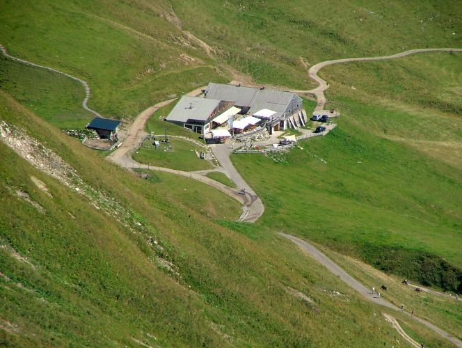
At the top, the road reaches the Schlappold-Alpe itself, the largest and highest-situated dairy alp in Germany, with written records reaching back to the 15th century and continuous dairy operation since the mid-1800s. Its terrace serves cheese made on site and cold drinks in season, with views east across the Allgäu's main ridge toward the Mädelegabel and Trettachspitze - a real reward for one of the steepest sustained climbs in the country.
PLAN YOUR ROUTE
 We've partnered with Sherpa-Map.com to bring you the best route planning tool. With a PRO Membership you can use this climb as a reference when creating your route.
 Schlappoldalpe averages 11.4% over 7.3 km (4.5 mi), but that number badly undersells the middle of the climb. The steepest 100 yards hits 20.9%, and the steepest full mile still averages 17.2% - sustained ramps that put this climb among the hardest paved (or alm-paved) ascents anywhere in the Alps.
The gradient is wildly uneven start to finish. The first 700 m out of the Stillachtal average close to 15%, then the road eases briefly onto a short false-flat near the Ringang farm - the only real recovery on the entire route. From there it tips up again into a long stretch of switchbacks beneath the Fellhornbahn cable car, holding 14-17% for kilometers with pitches over 20% on several of the tighter hairpins. The steepest ground comes in the final third, on the ramp leading up to the Fellhornbahn mid-station, before the last 500 m relaxes to a comparatively gentle 10%.
Roadway: The alm road beneath the Fellhornbahn is paved for nearly its entire length, though the first 500 m from the Stillach river crossing near the ski jump is unpaved gravel - start instead from the road past the Skiflugschanze if you want tarmac the whole way. Surface quality on the paved sections has been reported as good throughout, with a few rough or patched patches and a stretch of loose chip-seal on the lower switchbacks. The road is closed to public motor vehicles above the valley - only farm and service traffic uses it - and the alp itself is only open mid-May through late October, so plan around snow outside that window.
Traffic: None from cars. Expect hikers and Fellhornbahn cable-car day-trippers around the Schlappoldalpe hut and the mid-station near the top, especially at midday in summer; the lower switchbacks see almost no one, since even local mountain bikers largely avoid a grade this sustained.
Parking: The municipal Parkplatz Fellhornbahn, at the cable car's valley station on Fellhornbahnstraße, holds about 180 cars and costs €5 for the day (7am-6pm, pay by meter or the Parkster app); it sits right at the base of the climb. Free street parking can also be found closer to central Oberstdorf near the Skiflugschanze, a short pedal from the start.
Gearing is the single most important prep for Schlappoldalpe - a compact crank paired with at least a 32-tooth cog is the bare minimum, and riders who've done it generally recommend going lower still, toward a mountain-bike-range cassette or a sub-1:1 lowest gear, to survive the sustained 17-20%+ pitches in the middle third. Standing to climb works on short ramps elsewhere but isn't sustainable here for more than a few hundred meters at a time.
The Schlappoldalpe hut at the top serves drinks and simple alpine fare, much of it made on site including its own mountain cheese, but only from roughly 10am to 4pm and only between mid-May and late October - outside those hours or that season there's nothing open on the mountain. Carry more water than you'd expect for a climb this short; the exposed switchbacks get full sun most of the day with no shade and no other services between the base and the alp.
Check your brakes and bring a helmet before you start - the descent is as demanding as the climb, narrow and steep with loose gravel in patches, and it's the same road you'll ride back down. There are no bike shops on the mountain, so stock up in Oberstdorf beforehand.
Before heading out on any cycling adventure check out our Things to Bring on a Cycling Trip and use our interactive check list to ensure you don't forget anything.
Oberstdorf is one of Germany's biggest alpine tourism towns with every kind of lodging and service, and it's already the base for Nebelhorn, one of the country's other legendary climbs, a few kilometers away - see our Nebelhorn page for more on staying in town.
What's specific to this side of Oberstdorf is the Fellhorn itself: its slopes are locally billed as the most beautiful flower mountain in Europe, and the Fellhornbahn cable car that parallels the entire climb continues from the top of this road over the ridge into Austria's Kleinwalsertal - worth a look before or after you ride, and a way to preview the climb from above if you want to see what you're in for first.
At the Schlappoldalpe hut, there's a small petting zoo and playground for kids, and on Tuesday and Thursday afternoons in summer you can watch the on-site cheesemaking firsthand.
Ride between June and September; the upper switchbacks are fully exposed and can hold wet gravel or snow into early summer, and the alp itself doesn't open until mid-May at the earliest. Check conditions at altitude before you go with our Weather tool.
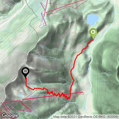
ROUTE MAP
MEMBER RATING
CURRENT WEATHER
PJAMM TRIPS ADVENTURE STARTER BUNDLES
Check out PJAMM Adventure's prepackaged (self-guided) cycling trips. They will help you plan, document and conquer your next adventure.
NEARBY CLIMBS (0) RADIAL PROXIMITY
FROM No Climbs Found
MEMBER REVIEWS & COMMENTS
Let us know what you thought of this climb. Signup for our FREE membership to write a review or post a comment.
Already have an account?
LOG IN HERE
