
20.1
PDI
11.9 mi
DISTANCE
3,705 ft
GAINED
5.2 %
AVG. GRADE
FULL CLIMB STATS
INTRO
This Furkajoch route from Sonntag is really two passes in one: 19.2 km (11.9 mi) and 1,129 m (3,705 ft) of gain at a 5.2% average, from 743 m (2,437 ft) in the Großes Walsertal to the Furkajoch road at 1,735 m (5,692 ft). The first 10 km (6.2 mi) are the Faschinajoch climb up the L193 through Türtsch, Seeberg and Fontanella to Faschina at about 1,486 m (4,875 ft); a short descent through Oberdamüls follows, and the road then climbs again on the Furkastraße to the pass, which is usually listed at about 1,760 m (5,774 ft).
The ride starts on sunny lower slopes at Sonntag-Garsella and builds to 9-11% around km 4-5 and km 7-9, with the steepest kilometer averaging 11.1%. The Furkajoch half is gentler: rolling at first, then 7-9% for a few kilometers and an easier run into the top.
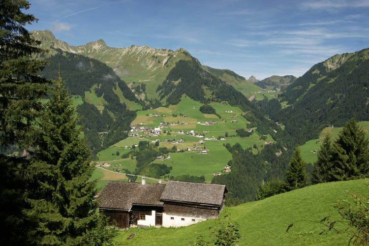
Sonntag sits in the Großes Walsertal biosphere reserve, a valley settled by Walser colonists from the Valais and ringed by Lechquellengebirge peaks such as the Rote Wand (2,704 m / 8,871 ft). The western approach to the Furkajoch, from Muntlix, is on our Furkajoch page.
PLAN YOUR ROUTE
 We've partnered with Sherpa-Map.com to bring you the best route planning tool. With a PRO Membership you can use this climb as a reference when creating your route.
This Furkajoch route climbs 1,129 m (3,705 ft) over 19.2 km (11.9 mi) for a 5.2% average, from 743 m (2,437 ft) to 1,735 m (5,692 ft). That average hides a descent in the middle: after about 9 km (5.6 mi) the road tops out at Faschina and drops roughly 120 m (390 ft) toward Oberdamüls before climbing again, for 137 m (450 ft) of total descent.
The steepest 0.5 km (0.3 mi) averages 11.5%, the steepest kilometer (0.6 mi) 11.1%, and the steepest 2 km (1.2 mi) 10.7%. The steepest 5 km (3.1 mi) average 8.9% and the steepest 10 km (6.2 mi) 6.7%, while the steepest 91 m (100 yd) reaches 12.3%.
The hard riding comes in two blocks: roughly 9-11% across km 4-5 and km 7-9 on the Faschina side, then 7-9% around km 13-15 after Damüls. The final 4 km (2.5 mi) start almost flat and finish at 5-6%.
Roadway: The route is paved throughout. The Faschinastraße (L193) is a well-built, winter-proof road that serves the Faschina ski area, but the Furkajoch road beyond Damüls is closed in winter; the main riding season is June to September, and May and autumn depend on snow and short-notice closures. Expect a steep, curving tunnel (the Stutztobeltunnel) on the way up to Faschina and the long Hahnenköpfle gallery of roughly 1.2-1.4 km (0.7-0.9 mi) beyond the pass, so bring working front and rear lights.
Traffic: Moderate. The good surface attracts motorcycles on both passes, and in the evening commuters head up the Großes Walsertal, so the approach roads through Thüringen and Raggal get busier; Raggal is the quieter of the two.
Parking: Sonntag is a village of only a few hundred people, so there is no dedicated cyclist lot at Garsella; park considerately in the village and ride from there. If you want to ride only the Furkajoch half, the Uga parking lot in Damüls is a practical alternative start.
Bring layers: the high point is above 1,700 m (5,577 ft), and the descent from Faschina to Damüls cools you down before the second climb. Carry a spare tube or tubeless kit and a pump, since there is no help once you leave the valley.
With 9-11% ramps in the first half and a long second climb, a compact crankset with a 30-32 tooth cassette is comfortable. Fill bottles in Sonntag or Fontanella, plan a stop in Faschina or Damüls, and remember that the kiosk at the Furkajoch summit, Zum Charly, is the next refreshment point once you leave Damüls.
Before heading out on any cycling adventure check out our Things to Bring on a Cycling Trip and use our interactive check list to ensure you don't forget anything.
Sonntag is the main gateway to the Großes Walsertal, a UNESCO biosphere reserve recognized in 2000 and settled centuries ago by Walser colonists from the Valais. The Museum Großes Walsertal is in Sonntag, the Propstei St. Gerold is the valley's cultural center, and guided tours with tastings run at the Biosphärenpark.haus; Walserstolz mountain cheese is the local product to look for, and the Walserherbst festival takes place every two years. Fontanella has a chapel of St. Anna and places to eat, and Faschina has cable cars and a small ski area in winter.
Over the pass, Damüls and the Bregenzerwald open a second region for riding. A bike-carrying bus (line 851, Au-Damüls-Au) helps with logistics in season, and the Uga parking lot in Damüls starts several road tours. You can link this climb with the Furkajoch's western side from Muntlix, which we cover on our Furkajoch page. For other climbs around Vorarlberg, or to build a custom route from here, use our Routes in the Area tool.
ROUTE MAP

MEMBER RATING
CURRENT WEATHER
PJAMM TRIPS ADVENTURE STARTER BUNDLES
Check out PJAMM Adventure's prepackaged (self-guided) cycling trips. They will help you plan, document and conquer your next adventure.
NEARBY CLIMBS (0) RADIAL PROXIMITY
FROM No Climbs Found
MEMBER REVIEWS & COMMENTS
Let us know what you thought of this climb. Signup for our FREE membership to write a review or post a comment.
Already have an account?
LOG IN HERE
