
23.8
PDI
20.1 mi
DISTANCE
4,883 ft
GAINED
4.6 %
AVG. GRADE
FULL CLIMB STATS
INTRO
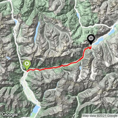
Passo del Maloja from Chiavenna is one of the Alps' great long-haul climbs: 32.3 km (20.1 mi) gaining 1488 m (4,883 ft) at a 4.6% average, from 329 m (1,079 ft) in Chiavenna to 1811 m (5,941 ft) at Maloja, the gateway to Switzerland's Upper Engadin. The route follows the whole length of Val Bregaglia (Bergell), crossing from Italy into Switzerland at Castasegna about 10 km in.
The modest average hides a climb built in steps. The first 10 km on the Italian side barely feel like a pass road, rising at 2-4% past Piuro and the Acquafraggia waterfalls. After the border the gradient picks up toward Promontogno, then a first set of 7-8 hairpins climbs above Vicosoprano. A flat stretch into Casaccia lulls you before the finale: the famous stack of 13 tight switchbacks that climbs the valley's headwall straight to the pass.
Along the way the landscape changes completely - chestnut groves, vineyards and stone villages low down, then larch forest and granite walls at the top, where the road arrives almost level with the lakes of the Upper Engadin. Maloja is Bregaglia's only road link with the rest of Switzerland and is kept open year-round, and from Chiavenna it pairs naturally with the Splügen Pass for one of the classic big loops of the Central Alps.
PLAN YOUR ROUTE
 We've partnered with Sherpa-Map.com to bring you the best route planning tool. With a PRO Membership you can use this climb as a reference when creating your route.
 Passo del Maloja from Chiavenna is 32.3 km (20.1 mi) long, gaining 1488 m (4,883 ft) at a 4.6% average from 329 m (1,079 ft) to 1811 m (5,941 ft).
Km 0-10 (Chiavenna to Castasegna): mostly 2-4%, with one kilometer near 6.6% and another at 6.3%.
Km 10-20 (Castasegna to Vicosoprano): steadier climbing with kilometers at 7.4% and 7.7%, broken up by a near-flat kilometer (1.5%) mid-valley.
Km 20-25 (Vicosoprano hairpins): the first real pass section, holding 5.9-8.2% per kilometer.
Km 25-27 (Casaccia): nearly flat - a chance to recover before the headwall.
Km 27-32 (Maloja hairpins): kilometers at 7.5%, 8.1% and 8.3%, with the final 3 km averaging about 7.7%.
Steepest sections: 100 yd (91 m) at 10.7%, 0.5 km at 10.3%, 1 km at 9.1%, 2 km at 8.7%, 5 km at 7.1% and 10 km at 6.1%.
Roadway: A main two-lane road paved the entire way - the SS37 in Italy and Swiss Route 3 beyond Castasegna - and kept open all year. Cyclists aren't allowed in the tunnel that bypasses Promontogno; follow the signed detour of about 1.5 km through the village, whose narrow main street is paved with stone setts. The Maloja hairpins are tight, with rougher patches on the inside of the bends. If you're continuing into the Engadin, rockfall-clearing work between Maloja and Sils is causing timed closures in late September and early October 2026 (bikes are diverted via Sils Maria), so check Graubünden's road reports before heading on toward St. Moritz.
Traffic: Moderate to busy. This is the main road between Lombardy and the Engadin, so expect steady cars and tour buses in summer, especially on weekends. The valley floor below the border is the busiest part - traffic spreads out on the upper climb, but stay alert for tour buses swinging wide through the tight Maloja hairpins.
Parking: Chiavenna has several public car parks around the historic center and the train station - it's the end of the rail line from Milan via Colico, so you can also arrive without a car. Riders who'd rather skip the gentle Italian valley can start at the border in Castasegna. At the top, Maloja village has public parking if you're meeting a support car.
Gear: Nothing on this climb goes much beyond 10%, so a standard compact with a 28-30 cog is plenty. The bigger challenge is the temperature swing: it can be hot in Chiavenna at 329 m and cold and windy at 1811 m, so bring a vest and arm warmers for the top and the descent. Castasegna is a Schengen border crossing, but Switzerland is outside the EU customs union - carry ID.
Provisions: Chiavenna is the last proper town for supplies. Just past the border in Castasegna there's a large roadside fuel station with a shop, a useful top-up point. The Bregaglia villages above are small, so don't count on much between Castasegna and Maloja. Prices jump to Swiss levels (francs) once you cross, though cards are widely accepted.
Before heading out on any cycling adventure check out our Things to Bring on a Cycling Trip and use our interactive check list to ensure you don't forget anything.
Chiavenna is worth more than a quick coffee. The town is known for its crotti - natural caves in the rock where cool air flows out year-round at around 8-10 C. For centuries they were used as natural cellars, and many are now rustic restaurants serving local cured meats, cheeses and wine.
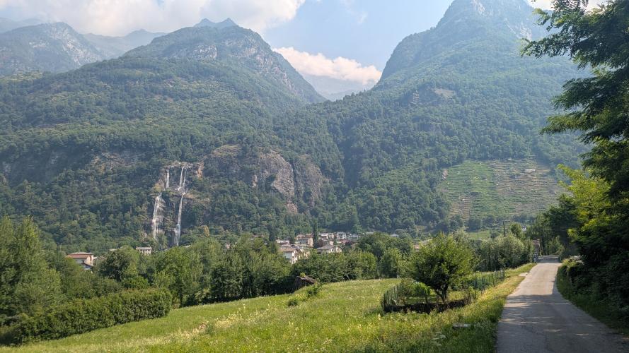
Just up the road at Borgonuovo di Piuro (around km 5), the twin cascades of the Cascate dell'Acquafraggia drop right beside the SS37 - visible from the saddle and a five-minute detour to their base. Piuro itself was one of the richest towns in the region until a landslide buried it in 1618; it's often called the 'Pompeii of the Alps,' and the archaeological remains of the old town can be visited.
Higher up, the steep side road from Promontogno to the stone village of Soglio is a rewarding detour if the legs allow. And because Chiavenna is also the base for the Splügen Pass, a Splügen-Julier-Maloja loop is a classic big day in the saddle - see other climbs nearby, or build a custom route from here, with our Routes in the Area tool.
ROUTE MAP
MEMBER RATING
CURRENT WEATHER
PJAMM TRIPS ADVENTURE STARTER BUNDLES
Check out PJAMM Adventure's prepackaged (self-guided) cycling trips. They will help you plan, document and conquer your next adventure.
NEARBY CLIMBS (0) RADIAL PROXIMITY
FROM No Climbs Found
MEMBER REVIEWS & COMMENTS
Let us know what you thought of this climb. Signup for our FREE membership to write a review or post a comment.
Already have an account?
LOG IN HERE
