13.6
PDI
6.6 mi
DISTANCE
2,303 ft
GAINED
6.5 %
AVG. GRADE
FULL CLIMB STATS
INTRO
This 6.6 mile bike climb is located in Kanagawa, Japan. The average gradient is 6.5% and there is a total elevation gain of 2,303 ft, finishing at 2,578 ft.
Use the profile tool, route map, and weather forecast to conquer this cycling climb.
Use the profile tool, route map, and weather forecast to conquer this cycling climb.
PLAN YOUR ROUTE
This climb averages 0%. The steepest quarter mile of this climb is 0%. NaN miles of the climb is at or above 10% grade. The gradient on this climb is broken down as follows:
See more details and tools regarding this climb's grade via our interactive Profile Tool.
See more details and tools regarding this climb's grade via our interactive Profile Tool.
Information Not Available
If you have any information regarding this climb, we'd like to hear from you. Click the CONTRIBUTE button to share your thoughts with us.
Information Not Available
If you have any information regarding this climb, we'd like to hear from you. Click the CONTRIBUTE button to share your thoughts with us.
Before heading out on any cycling adventure check out our Things to Bring on a Cycling Trip and use our interactive check list to ensure you don't forget anything.
Information Not Available
If you have any information regarding this climb, we'd like to hear from you. Click the CONTRIBUTE button to share your thoughts with us.
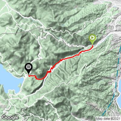
ROUTE MAP
MEMBER RATING
CURRENT WEATHER
PJAMM TRIPS ADVENTURE STARTER BUNDLES
Check out PJAMM Adventure's prepackaged (self-guided) cycling trips. They will help you plan, document and conquer your next adventure.
NEARBY CLIMBS (0) RADIAL PROXIMITY
FROM No Climbs Found
MEMBER REVIEWS & COMMENTS
Let us know what you thought of this climb. Signup for our FREE membership to write a review or post a comment.
Already have an account?
LOG IN HERE
brutoru


This is the old Tokaido (one of 5 main throughfares since medieval times) Hakone pass crossing. The National Route 1 (NR 1) takes a more winding route over. Coming from Odawara on NR 1, you take the bridge to the left just as the Hakone Yumoto train terminal comes into view (photo 1). You climb steadily through the many hot spring spa hotels for 6kms to the old way station village of Hatashuku. From there you tackle the Nanamagari (7-curves) switchbacks for 2kms at around 8%. Once past this zone its another 2kms to the peak at Otama Lake, then a short descent to Lake Ashi where Mt.Fuji will be in view on a good weather day (photo 2)