27.7
PDI
9.5 mi
DISTANCE
3,952 ft
GAINED
7.9 %
AVG. GRADE
FULL CLIMB STATS
Page Contributor(s): Bruce Hamilton, Palm Desert, CA, USA; Carl Hansen, Guernsey, UK
INTRO
Plateau de Beille climbs 15.3 km (9.5 mi) from the edge of Château-Verdun, in the Ariège Pyrenees, to the Nordic ski station on the plateau at about 1,777 m (5,829 ft), gaining 1,205 m (3,952 ft) at a 7.9% average. The D522 rises from the valley near Les Cabannes, between Tarascon-sur-Ariège and Ax-les-Thermes, and it is a dead end that serves only the station, which keeps traffic light outside ski season.
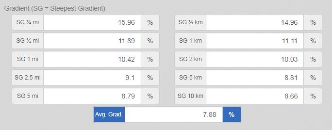
This is one of the more difficult climbs in the Pyrenees. The steepest mile averages 10.5% (1.6 km) and even the hardest 5 km (3.1 mi) holds 8.8%, with only brief breathers in a long forested lower half before the trees thin out and the views open up. Once you reach the Nordic station the payoff is a wide, high plateau.
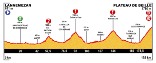
The Tour de France has finished on Plateau de Beille seven times between 1998 and 2024, with stage winners including Marco Pantani (1998), Alberto Contador (2007), Jelle Vanendert (2011), Joaquim Rodríguez (2015) and Tadej Pogačar, who won stage 15 here on July 14, 2024.
PLAN YOUR ROUTE
 We've partnered with Sherpa-Map.com to bring you the best route planning tool. With a PRO Membership you can use this climb as a reference when creating your route.
 The average grade is 7.9% over 15.3 km (9.5 mi), and it rarely lets up. The steepest mile (1.6 km) averages 10.5%, the steepest kilometer (0.6 mi) 10.4%, the steepest 5 km (3.1 mi) 8.8% and the steepest 10 km (6.2 mi) 8.6%. The hardest kilometer comes around km 9 (mile 5.6).
You get short breathers at about km 5 to 6 (miles 3.1 to 3.7), km 11 to 12 (miles 6.8 to 7.5) and in the final kilometer, but most of the rest of the climb is between 7% and 10%. Pace the first third conservatively, because the opening kilometers already run at 7.5% to 9.5%.
Roadway: The D522 is paved all the way to the top. A long middle stretch of the road was resurfaced in spring 2024, the same year the Tour returned, so the surface is in good shape. The road is narrow in places with tight bends, and it can be affected by weather; check Ariège's Inforoute09 road information before you go.
Traffic: Very light outside the ski season. The D522 is a dead end serving only the station, so most traffic is local, plus walkers heading for the GR10 crossing on the plateau. You may encounter farm animals (and lots of flies) on the road. The main N20 in the valley can be busy, which matters if you ride in from Ax-les-Thermes or Tarascon-sur-Ariège.
Parking: You can park in Les Cabannes, where the D522 leaves the valley. If someone is picking you up, there is free parking at the station at the top, in upper and lower lots. Riders can also start from Ax-les-Thermes or Tarascon-sur-Ariège, though the N20 in between can have heavy traffic.
Summer in the Pyrenees is normally warm and sunny, even at higher elevations, but there are periods of low cloud that can make the climbs quite damp. The finish is at about 1,777 m (5,829 ft), so bring warm clothes just in case.
There is water, food and toilets at the top during certain hours; the station has a bar and restaurant (L'Échappée Beille) and a boutique in summer, but carry your own water as hours vary. For a bike shop, Ax-les-Thermes has a rental and repair workshop (Loc de Sault), and Tarascon-sur-Ariège also has bike rental.
Before heading out on any cycling adventure check out our Things to Bring on a Cycling Trip and use our interactive check list to ensure you don't forget anything.
Tarascon-sur-Ariège, a few minutes from the foot of the climb, is the natural base for Beille and has restaurants and shops for food. It is also the gateway to some of the Pyrenees' best prehistoric sites: the Grotte de Niaux, about 7 km away, holds 17,000-year-old cave paintings (visits are by timed tour with limited numbers), and the Parc de la Préhistoire is a good rest-day stop. Foix and its château lie about 18 km to the north. For a base with thermal baths, Ax-les-Thermes is covered in our Col de Pailhères pages.
On the plateau itself there is more than the climb: the GR10 crosses it, there is a summer transhumance trail between Beille and Inclès, and e-mountain-bike hire is available at the station. At 1,777 m the weather can differ a lot from the valley, so check our Weather tool for conditions at the top before you set off.
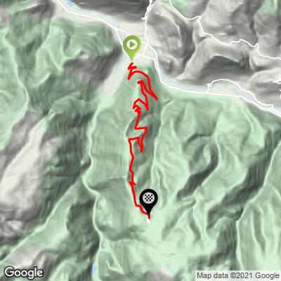
ROUTE MAP
MEMBER RATING
CURRENT WEATHER
PJAMM TRIPS ADVENTURE STARTER BUNDLES
Check out PJAMM Adventure's prepackaged (self-guided) cycling trips. They will help you plan, document and conquer your next adventure.
NEARBY CLIMBS (0) RADIAL PROXIMITY
FROM No Climbs Found
MEMBER REVIEWS & COMMENTS
Let us know what you thought of this climb. Signup for our FREE membership to write a review or post a comment.
Already have an account?
LOG IN HERE
carlinguernsey
This is one of the harder climbs in the Pyrenees with good scenery once you get up on the Plateau.