Melin y Coed Bike Climb - PJAMM Cycling

3.2
FIETS
2 mi
DISTANCE
1,039 ft
GAINED
10.1 %
AVG. GRADE

FULL CLIMB STATS

INTRO

This 2 mile bike climb is located in Cymru, United Kingdom. The average gradient is 10.1% and there is a total elevation gain of 1,039 ft, finishing at 1,219 ft.

Use the profile tool, route map, and weather forecast to conquer this cycling climb.

See more details and tools regarding this climb's grade via our interactive Profile Tool.
Information Not Available

If you have any information regarding this climb, we'd like to hear from you. Click the CONTRIBUTE button to share your thoughts with us.

Information Not Available

If you have any information regarding this climb, we'd like to hear from you. Click the CONTRIBUTE button to share your thoughts with us.

Before heading out on any cycling adventure check out our Things to Bring on a Cycling Trip and use our interactive check list to ensure you don't forget anything.
Information Not Available

If you have any information regarding this climb, we'd like to hear from you. Click the CONTRIBUTE button to share your thoughts with us.

ROUTE MAP

MEMBER RATING

Not Yet Rated
-
Road
-
Traffic
-
Scenery

CURRENT WEATHER

PJAMM TRIPS ADVENTURE STARTER BUNDLES

Check out PJAMM Adventure's prepackaged (self-guided) cycling trips. They will help you plan, document and conquer your next adventure.
ALL TRIPS
Browse all of our prepackaged trips and find your next adventure!

NEARBY CLIMBS (0) RADIAL PROXIMITY

FROM
No Climbs Found

MEMBER REVIEWS & COMMENTS

Let us know what you thought of this climb. Signup for our FREE membership to write a review or post a comment.
Already have an account?
ROUTE MAP
PROFILE TOOL
Route Data
S.G. (%)
hide
Segment Data
hide

Climb Profile Not Found
CLIMB SUMMARY

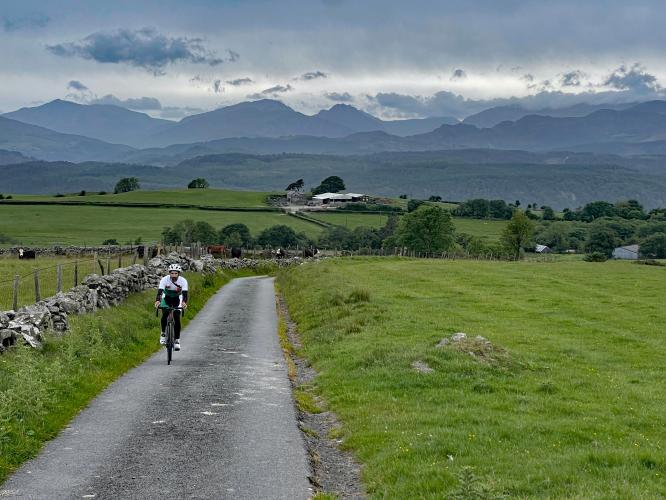
one-lane country road surrounded by green pastures; mountains in distance

Cycling Melin y Coed, Wales

Ride two miles gaining 1,055’ at 10.3% average grade.

This climb has one very steep segment near the beginning of the climb: a full half-mile at 16.5%.  Simon Warren lists this as the third hardest climb in Wales, and sixth toughest in all the UK.

photo collage of PJAMM Cyclist riding along one-lane country roadway, pastureland, stone buildings

PJAMM Cyclist rides along roads lined with stone walls and ivy hedges

An old church across a stone bridge marks the start point of the climb up Melin y Coed. The road is narrow, as nearly all of the residential roads are in this corner of the world. Melin y Coed however, is narrow even by Welsh standards.

Tree tunnel near climb's start

Tree tunnel within the first 200 yards of start.

photo collage shows views along first half of climb, densely forested roadway, bike parked in front of old stone church

Scenes along the first half of the climb.

photo collage shows views along the climb route: pink foxgloves, green pastureland

You’ll pass a few homesteads en route to the top and it is clear that not much has changed out here for the last few hundred years.

old brick building with sign reading "No unauthorised access to buildings without permission"

Nine-tenths mile mark.

 There is one livestock gate to contend with on your ride to the top, but it is easily opened and not a ‘Private Property’ gate - it’s only there to keep the livestock in. The summit is at a ‘T’ intersection with a main(ish) road.

 PJAMM Cyclist closes livestock gate behind him

Gate at mile 1.3.

On a clear day, this is a spectacular view and certainly one worth doing. You can see the cows, sheep, and goats grazing. Overall this climb is tough at first but after the first mile, the road and gradient become easier, and it is well worth doing, especially if you include the ride through the town and bridge near the start.

PJAMM Cyclists stand with bikes at climb finish, aerial drone view

Climb’s finish.

That’s a wrap!

Access to full Climb Summary requires a PJAMM Cycling PRO Membership!

It takes less than a minute to sign up & with your PRO membership you can:
  • Rate climbs, post comments and share your experiences on any of our climb pages
  • Create bucket lists of climbs & mark the dates you complete them
  • Weather data for all climbs - Start & Finish
  • Upload photos to your member page to customize your PJAMM Cycling experience
  • Utilize all of our interactive tools - Profile & Routes in Area
  • Download climb route .gpx files
LEARN MORE
SIGN UP

Already have an account? LOG IN HERE