Migneint Pass Bike Climb - PJAMM Cycling

3.6
PDI
8.4 mi
DISTANCE
1,092 ft
GAINED
2.2 %
AVG. GRADE

FULL CLIMB STATS

INTRO

This is a great one in the moorland Snowdonia and is a Top 10 Wales Most Epic Hill Climb. 

Visit our UK Top 10 Epic Hill Climbs and our Top 10 Epic Welsh Hill Climbs pages for photos, summaries and statistics for their respective top epic hill climbs. 

PLAN YOUR ROUTE

We've partnered with Sherpa-Map.com to bring you the best route planning tool. With a PRO Membership you can use this climb as a reference when creating your route.

See more details and tools regarding this climb's grade via our interactive Profile Tool.
Information Not Available

If you have any information regarding this climb, we'd like to hear from you. Click the CONTRIBUTE button to share your thoughts with us.

Information Not Available

If you have any information regarding this climb, we'd like to hear from you. Click the CONTRIBUTE button to share your thoughts with us.

Before heading out on any cycling adventure check out our Things to Bring on a Cycling Trip and use our interactive check list to ensure you don't forget anything.
Information Not Available

If you have any information regarding this climb, we'd like to hear from you. Click the CONTRIBUTE button to share your thoughts with us.

ROUTE MAP

MEMBER RATING

Not Yet Rated
-
Road
-
Traffic
-
Scenery

CURRENT WEATHER

PJAMM TRIPS ADVENTURE STARTER BUNDLES

Check out PJAMM Adventure's prepackaged (self-guided) cycling trips. They will help you plan, document and conquer your next adventure.
ALL TRIPS
Browse all of our prepackaged trips and find your next adventure!

NEARBY CLIMBS (0) RADIAL PROXIMITY

FROM
No Climbs Found

MEMBER REVIEWS & COMMENTS

Let us know what you thought of this climb. Signup for our FREE membership to write a review or post a comment.
Already have an account?
ROUTE MAP
PROFILE TOOL
Route Data
S.G. (%)
hide
Segment Data
hide
CLIMB SUMMARY

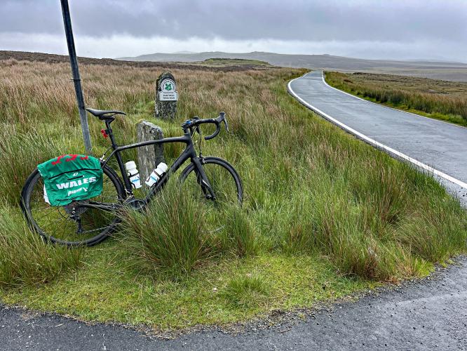
National Park sign on side of one-lane road, tall grass

Cycling Migneint Pass, Wales

Ride 8.4 miles gaining 1,084’ at 2.1% average grade (3.1% climb only).

An easy but epic Welsh bike climb.  This climb is through an expansive moorland in central Snowdonia, northwest Wales.

photo collage shows bike parked next to various National Park and Estate signs, moorland, street signs for Pentrefoelas, Betws-y-Coed

Simon Warren ranks Migneint Pass the eighth most epic bike climb in Wales.

photo collage, stone fence, sign for Ysbyty Ifan, Ffestinoig, PJAMM Cyclist stands with bike in center of intersection, green pastureland

There is a meat and potatoes portion of Migneint Pass and then there is a green bean portion. Hmm, I’m not sure if that analogy works. Anyway, the opening miles are very mellow gradients that see you through a number of small farms. The last third of the climb ramps up a bit and takes you away from any civilization and into an open tundra-like landscape. The summit is at a ‘Y’ intersection without much else around. You can reliably bet on some high winds and rain out here so pack accordingly.

various cows graze in pastures along roadside

Pasturland and grazing animals along the first half of the climb.

photo collage shows PJAMM Cyclist riding through fog and mist on country roadway surrounded by rolling moorlands

On a clear day, this could be a beautiful open space, on a rainy windy day, it adds to the challenge of this road. The main climb of about a couple of miles is sandwiched in between some rolling open moorland at the top and rolling farms at the bottom.

one-lane roadway snakes through open moorland, misty, foggy day

Windswept landscape of the moor.

bike parked at low stone barrier where road crosses the River Conwy

Cross River Conwy at mile 7.

bike parked at climb's finish, wide open views of moorland, foggy day

Finish with wide open views of moorland.