
16.5
PDI
5.2 mi
DISTANCE
2,311 ft
GAINED
8.5 %
AVG. GRADE
FULL CLIMB STATS
INTRO
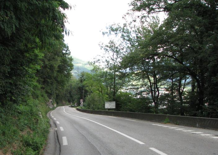
Truck drivers know this road better than cyclists do, and not fondly. The Rampe de Laffrey drops off the Matheysine plateau to Vizille at close to 10% for 6 km with only a few broad bends, and heavy trucks and coaches have been barred from the descent since the 1970s - a height barrier at the top now stops them physically. Going up, that's a small mercy: the cars and vans are all still here, but the big stuff isn't.
From the bottom of the ramp it's 8.3 km (5.2 mi) and 704 m (2311 ft) of climbing at 8.5%, and the first 6 km are the climb: 9.4% on average, with every kilometer between 8.8% and 9.8%. There's nowhere to recover and not much shade. The ramp tops out in the village of Laffrey around 910 m, and our route turns right toward Saint-Jean-de-Vaulx for an easier last 1.4 km at about 6% to 1002 m.
Eight times the Tour has crossed it as a categorized climb, from 1951, when Gino Bartali led over the top, to 2010, on the stage from Chambéry to Gap. The road has a darker history too. More than 150 people died in crashes on the descent between 1946 and 2007, most of them pilgrims coming down from the shrine at La Salette - our Sanctuaire Notre-Dame de la Salette climb - in coaches whose brakes failed. The worst, in 1973, killed 43; the last, in July 2007, killed 26 Polish pilgrims. It's why the bottom of the hill now has a concrete barrier and an emergency arrester bed.
PLAN YOUR ROUTE
 We've partnered with Sherpa-Map.com to bring you the best route planning tool. With a PRO Membership you can use this climb as a reference when creating your route.
It's steep from the first meter. Kilometer by kilometer from the bottom of the ramp at 297 m: 8.8%, 9.0%, 9.8%, 9.4%, 9.8% and 9.4%, which puts you at 858 m after 6 km - a 9.4% average without a break. The steepest kilometer averages 10.2% and the steepest 500 m 11.1%. You'll see bigger numbers quoted for the descent, 12% and more, but those are short pitches; over any full kilometer the ramp sits at 9-10%.
The gradient eases to about 6% as you reach the village of Laffrey at around 910 m (km 6.8). Our route then turns right toward Saint-Jean-de-Vaulx: 1.4 km at 6.3% on a narrower road to the finish at 1002 m.
Overall: 8.3 km (5.2 mi), 704 m (2311 ft) of climbing, 8.5% average.
Roadway: The N85 is a wide, well-surfaced national road, three lanes in places near the top, with no real shoulder for most of its length. The bottom section was rebuilt between 2022 and 2024, when the road was shifted toward the cliff to make room for an arrester bed for runaway vehicles, and the cliffs above it are netted against rockfall. The descent is fast and straight - riders report 70-85 km/h without trying - so stay in control with cars overtaking. The last 1.4 km toward Saint-Jean-de-Vaulx is a narrow, quiet local road.
Traffic: Heavy. This is the main road from Grenoble to La Mure and Gap, and nearly every rider who reviews it mentions the cars: a steady stream, little room, exhaust on hot days. Vehicles over 7.5 tonnes and coaches are banned from the descent except for authorized local services, so trucks are rare. Ride it early on a weekend morning if you can.
Parking: Park in Vizille, a few hundred meters from the start across the Romanche. The Domaine de Vizille, the château park, has parking nearby and free entry, which makes it a handy meeting point before and after the ride.
Gear: Six kilometers at 9-10% with no let-up is a long time on one gear. Most riders will want their lowest gear - 34x30 or smaller - and to settle into it early. Front and rear lights are worth having on a road this busy.
Provisions: Vizille has shops, bakeries and cafés; there's nothing on the ramp itself. At the top, Laffrey's lakes have restaurants and a hotel along the shore of the Grand Lac.
Before heading out on any cycling adventure check out our Things to Bring on a Cycling Trip and use our interactive check list to ensure you don't forget anything.
The château at the bottom is the Domaine de Vizille, where the Assembly of Vizille met in 1788 - it houses the Musée de la Révolution française, and its park, with a big lake, canals and deer and herons roaming free, is free to walk around.
At the top, the Laffrey lakes are the reason to linger. There are four - the Grand Lac de Laffrey, Pétichet, Pierre-Châtel and Lac Mort - with pebble beaches at both ends of the Grand Lac, sailing and rowing clubs, and unsupervised swimming off the gently sloping beach at Pétichet. The Prairie de la Rencontre, where Napoleon talked the royal troops sent to arrest him into joining him on 7 March 1815, is on the shore of the Grand Lac; our Col de la Morte (Séchilienne) page has more on it and on the 51 km lakes loop.
The Laffrey plateau joins up with plenty of quieter climbs - Col de la Morte, Col du Luitel and Chamrousse all start from the Romanche valley a few kilometers east of Vizille. If you'd rather climb onto the plateau without the N85's traffic, Routes in the Area on this page shows how those roads connect.
ROUTE MAP

MEMBER RATING
CURRENT WEATHER
PJAMM TRIPS ADVENTURE STARTER BUNDLES
Check out PJAMM Adventure's prepackaged (self-guided) cycling trips. They will help you plan, document and conquer your next adventure.
NEARBY CLIMBS (0) RADIAL PROXIMITY
FROM No Climbs Found
MEMBER REVIEWS & COMMENTS
Let us know what you thought of this climb. Signup for our FREE membership to write a review or post a comment.
Already have an account?
LOG IN HERE
