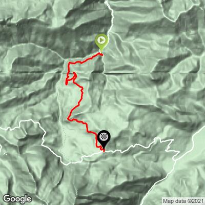
Col du Soulor (Ferrières) Bike Climb - PJAMM Cycling

7.3
FIETS
7.3 mi
DISTANCE
3,017 ft
GAINED
7.6 %
AVG. GRADE

FULL CLIMB STATS

Page Contributor(s): Lynn Sugden, Sherwood Park, AB, Canada

INTRO

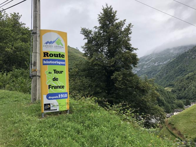
It is not well known that as you travel east on D918 the Col d’Aubisque ends at the Station de Ski de Fond du Val d’Azun and you then ride the west – east portion of the Col de Soulor eventually ending in the town square of Argelès-Gazost. We stayed 5 nights at Des Pyrenees on the square - it was reasonably priced and a comfortable place to stay with a great view over the town square.

See more details and tools regarding this climb's grade via our interactive Profile Tool.
Information Not Available

If you have any information regarding this climb, we'd like to hear from you. Click the CONTRIBUTE button to share your thoughts with us.

Information Not Available

If you have any information regarding this climb, we'd like to hear from you. Click the CONTRIBUTE button to share your thoughts with us.

Before heading out on any cycling adventure check out our Things to Bring on a Cycling Trip and use our interactive check list to ensure you don't forget anything.
For those looking to stay in the area we would recommend the Pyrenees Cycling Lodge. Located in the beautiful medieval village of Saint Savin and hosted by Mark & Niamh, the Lodge is run by cyclists for cyclists. It is a great location for any cycling adventure in the Pyrenees with several renowned climbs within 100km of the property and 6 Tour de France climbs within 15km. Visit their website or contact them directly at pyreneescyclinglodge@gmail.com .

ROUTE MAP

MEMBER RATING

Not Yet Rated
-
Road
-
Traffic
-
Scenery

CURRENT WEATHER

PJAMM TRIPS ADVENTURE STARTER BUNDLES

Check out PJAMM Adventure's prepackaged (self-guided) cycling trips. They will help you plan, document and conquer your next adventure.
ALL TRIPS
Browse all of our prepackaged trips and find your next adventure!

NEARBY CLIMBS (0) RADIAL PROXIMITY

FROM
No Climbs Found

MEMBER REVIEWS & COMMENTS

Let us know what you thought of this climb. Signup for our FREE membership to write a review or post a comment.
Already have an account?
ROUTE MAP
PROFILE TOOL
Route Data
S.G. (%)
hide
Segment Data
hide

Climb Profile Not Found
CLIMB SUMMARY

cycling Col du Soulor from Ferrieres - kilometer marker sign - km 12

Summary submitted by Lynn Sugden, Sherwood Park, AB, Canada

It is not well known that as you travel east on D918, the Col d’Aubisque ends at the Station de Ski de Fond du Val d’Azun, and you then ride west to Col de Soulor, eventually ending in the town square of Argelès-Gazost, one of PJAMM Cycling’s World Climb Areas.  We stayed five nights at Des Pyrenees on the square -- it was reasonably priced and a comfortable place to stay with a great view over the town square.  

View of neighboring Col d’Aubisque

The real gem is to follow D126, south bound, from Asson up to the Station de Ski de Fond du Val d’Azun.  This is the north-south portion of the Col de Soulor.  How we found this climb is a story in itself.  We stayed in Lourdes, among other things a cycling mecca and close to the Col de Tourmalet.  The LBS is owned by Hubert Arbès, an ex-pro.  He rode as Bernard Hinault's domestique while on Renault-Elf-Gitane in late 70’s and early 80’s.  In 1980, Hinaut, in the yellow jersey after Stage 12, abandoned the tour.  To avoid the media crush, they left by the back door and out of Pau.  Arbès left the tour at the same time.  He drove Hinaut to his house in southern France to hide from the media.

Talking with Hubert Arbès, once he established we were serious and not just tourists, he set us up on a couple very nice bicycles, map in hand and off to the Col du Soulor.  No regrets whatsoever!  Admittedly we found it on a bright, clear, warm day.  The ride starts with the mountains of the Parc national des Pyrénées in front of us as we rolled over gentle hills and through small, rural French towns.  Traffic was calm and accommodating.

As you arrive in Ferrières and Hougarou the climb begins.  At times the grade is challenging, however, the scenery takes your mind off of any muscle discomfort or oxygen deprivation.  

Bike climb Col du Soulor from Ferrieres - road and field

 Col du Soulor from Ferrieres - cyclists riding on road

You travel out of the forest and into highland farmland, then into mountain grazing pastures.  It is common to see sheep and cows wandering the slopes where there are no fences.

Biking Col du Soulor from Ferrieres - forest and roadway leading to col

As you climb further you turn a corner that uncovers an incredible scene.  Across the valley you can see the Col d’Aubisque cutting a path across the Cirque du Litor.  At the intersection of D126 and D918, stop for the obligatory café.  The ski station is 100 meters east of the café.  The descent down to Argelès-Gazost is fast and enjoyable.

TOUR DE FRANCE HISTORY

Col du Soulor was first featured in the 1912 Tour de France and has been included many times since then.  The race organizers truly were “assassins” -- as Octavio Lapize uttered on Tourmalet in 1910. TdF’s 1912 Stage 10, Luchon to Bayonne, was just plane gruesome -- 326 km with five cols: Peyresourde, Aspin, Tourmalet, Soulor and Aubisque.   Torturous and unbelievable -- truly!

Col du Soulor first appeared in the TdF on Stage 10 1912

Photo - hyperleap.com - 1912 Tour de France.

Soulor has not been considered a category climb when it is part of the approach to Col d’Aubisque.  During the post WWII Tour de France (1947) Soulor has been featured 12 times between 1973 and 2010 and will return in stage 14 July 20, 2019.  Other than receiving the prominent HC rank in 1982, it has most often been ranked a Cat 1, but for Cat 2 in 2000.  

Bicycle ride Col du Soulor from Ferrieres - tour de france paint on ground

Col du Soulor -- TdF made it famous and the Vuelta visited in 2016.  

Access to full Climb Summary requires a PJAMM Cycling PRO Membership!

It takes less than a minute to sign up & with your PRO membership you can:
  • Rate climbs, post comments and share your experiences on any of our climb pages
  • Create bucket lists of climbs & mark the dates you complete them
  • Weather data for all climbs - Start & Finish
  • Upload photos to your member page to customize your PJAMM Cycling experience
  • Utilize all of our interactive tools - Profile & Routes in Area
  • Download climb route .gpx files
LEARN MORE
SIGN UP

Already have an account? LOG IN HERE