
17.1
PDI
9 mi
DISTANCE
2,903 ft
GAINED
6.1 %
AVG. GRADE
FULL CLIMB STATS
INTRO
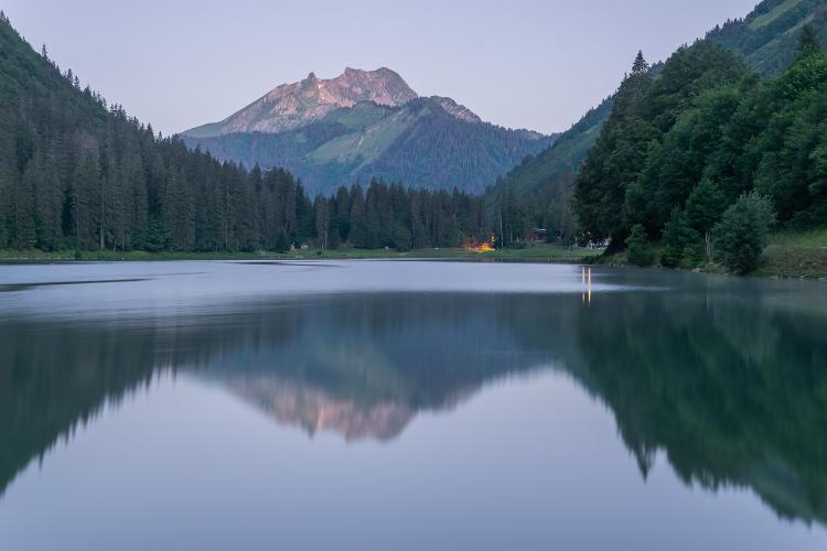
For a while this barely feels like a climb out of Morzine. After 2.5 km at a steady 6% the road reaches Lac de Montriond - a landslide lake under the cliffs, the third-largest in Haute-Savoie after Lake Geneva and Lake Annecy - and runs almost flat along the shore. Enjoy it, because the next part isn't flat at all.
Past the head of the lake the road climbs beside the Cascade d'Ardent, where the Dranse drops through a gorge right next to the road, and from there through Ardent to Les Lindarets you get the steepest 3 km of the day at about 9%. Les Lindarets is the goat village: the herd roams freely between restaurant terraces and onto the road, so take the hairpins through the hamlet slowly. Above it the climb eases, then settles into a steady 7% through spruce forest to the Col de la Joux Verte, where it meets the road up from Morzine.
Our route doesn't stop at the col. It carries on about 1.4 km (0.9 mi) to the entrance of Avoriaz at 1827 m (5995 ft), where the road ends at the edge of the car-free resort - 14.5 km (9.0 mi) and 885 m (2903 ft) of climbing in all, at 6.1%. One of our members called it a tough climb and maybe their favorite in the area, and the lake and Les Lindarets have a lot to do with that.
PLAN YOUR ROUTE
 We've partnered with Sherpa-Map.com to bring you the best route planning tool. With a PRO Membership you can use this climb as a reference when creating your route.
Montriond to Avoriaz is 14.5 km (9.0 mi), climbing from 943 m (3095 ft) to 1827 m (5995 ft) - 885 m (2903 ft) of gain at 6.1% on average. The Col de la Joux Verte itself comes at about 13.1 km (8.1 mi).
The first 2.5 km (1.6 mi) climb at about 6% to the lake, and the shore road is nearly flat for the next kilometer. From 3.5 km the grade builds again, and 5.5-8.5 km (3.4-5.3 mi), from the waterfall through Ardent to Les Lindarets, is the hardest stretch at about 9%: the steepest kilometer is 9.6% and the hardest 2 km (1.2 mi) 9.4%. Above Les Lindarets it eases to around 4.5% for 2 km, then holds near 7% through the forest to the col. The final 1.4 km (0.9 mi) to Avoriaz average a little over 5%.
The hardest 5 km (3.1 mi) average 8.1%.
Roadway: The whole climb is on the surfaced D228 - the Route du Lac, the Route des Lindarets and the Route de la Joux Verte. The pass road is open daily from mid-May to the end of October; when it closes for winter depends on the snow. The Haute-Savoie au Sommet program closes 10.5 km of the road from Montriond to motor traffic on a summer Tuesday morning (9:00-12:00) (past dates include 12 August 2025 and 28 July 2026), and that's the best time to ride it.
Traffic: Depends on when you go. On summer days the lake and Les Lindarets draw a lot of visitors, with cars and coaches on the narrow road, and the commune encourages people to use the summer shuttle buses instead of driving. Early mornings and the shoulder seasons are much quieter, and above Les Lindarets traffic thins out.
Parking: Start from Montriond or Morzine, a couple of kilometers away (Street View). If you drive up, there's a free car park with toilets at the far end of Lac de Montriond, and more parking at Ardent and Les Lindarets.
Gear: The steep part is 3 km at about 9%, with nothing much steeper, so normal mountain gearing is plenty. Use the flat lakeside kilometer to eat and drink before it starts. Bring a layer: you finish above 1800 m, and the descent is long.
Provisions: There are restaurants and picnic areas around the lake, and several restaurants with sun terraces at Les Lindarets (the village is open to visitors daily from June to September). Three of them - Cuirland, La Crémaillère and Le Vieux Chalet - sell €1 bags of goat food, if you want to make friends. Avoriaz has shops and cafes at the top in season.
Before heading out on any cycling adventure check out our Things to Bring on a Cycling Trip and use our interactive check list to ensure you don't forget anything.
Morzine is the base: a big summer cycling and mountain-bike town with plenty of hotels, restaurants and bike shops, and Montriond next door is quieter and usually cheaper. After the ride, Lac de Montriond has a supervised swimming area in July and August.
The Cascade d'Ardent is worth a stop off the bike - the commune has built a footpath loop so you can see it without walking along the road. From the col you can drop to Morzine on the other side (our Col de la Joux Verte page covers that side as a climb) for a loop, and Col de Joux Plane from Morzine and Col de l'Encrenaz are close by for a bigger day.
Avoriaz sits nearly 900 m above the lake, so a warm morning in Montriond doesn't promise much about the top - our Weather tool forecasts both ends of the climb.
ROUTE MAP

MEMBER RATING
CURRENT WEATHER
PJAMM TRIPS ADVENTURE STARTER BUNDLES
Check out PJAMM Adventure's prepackaged (self-guided) cycling trips. They will help you plan, document and conquer your next adventure.
NEARBY CLIMBS (0) RADIAL PROXIMITY
FROM No Climbs Found
MEMBER REVIEWS & COMMENTS
Let us know what you thought of this climb. Signup for our FREE membership to write a review or post a comment.
Already have an account?
LOG IN HERE
thall1
Tuff climb in morzine. Might be my favorite in the area. One of the sections is closed off to cars, plus the town of Lindarets and Lac du Montriond are goated.
Enjoyment: 86/100
