
23
PDI
5.9 mi
DISTANCE
2,927 ft
GAINED
9.5 %
AVG. GRADE
FULL CLIMB STATS
INTRO
Col du Luitel is a 1,259 m (4,131 ft) mountain pass in the Belledonne range of the French Alps, reached by a short, relentlessly steep road out of the Romanche valley village of Séchilienne. From the village at 367 m (1,204 ft), the climb covers 9.4 km (5.9 mi) and gains 892 m (2,927 ft) at a 9.5% average grade - one of the more sustained double-digit-adjacent ascents in the Grenoble area, with no flat sections anywhere to catch a breath.
The road is narrow and forested for essentially its entire length, holding a steady 9-11% grade through a series of hairpins with almost no view until the trees finally open near the top. At the pass itself sits the Réserve Naturelle du Lac Luitel, one of France's oldest nature reserves (established 1961), protecting a rare high-altitude peat bog and the plant and animal life that depends on it.
The Luitel has been part of Tour de France mountain-stage routes going back to the 1950s, most notably crested first by Charly Gaul - the "Angel of the Mountains" - in 1956, with other GC-era climbers such as Michel Pollentier (1978) and Roger De Cnijf (1981) leading over it in later editions.
PLAN YOUR ROUTE
 We've partnered with Sherpa-Map.com to bring you the best route planning tool. With a PRO Membership you can use this climb as a reference when creating your route.
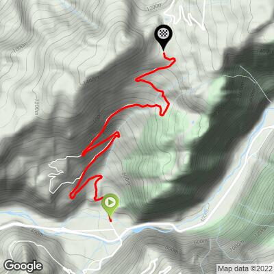
 From Séchilienne (367 m / 1,204 ft) to the Col du Luitel (1,259 m / 4,131 ft), the route covers 9.4 km (5.9 mi) and gains 892 m (2,927 ft) at a 9.5% average grade.
What stands out is how little the grade varies. There's no descending or flat ground anywhere on the climb, and even the steepest continuous 5-mile stretch still averages 9.9% - barely above the overall number. Shorter ramps bite harder: the steepest quarter mile averages 11.8%, and the steepest 100 yards touches 12.5%. Riders should expect a steady, grinding effort rather than the alternating steep-then-easy rhythm common on longer Alpine climbs.
Roadway: The road is paved the entire way, but it's a narrow communal road, not a major route, and the surface is patchy and bumpy in stretches rather than freshly resurfaced - go easy if descending this way. Conditions improve somewhat in the upper kilometers approaching the pass. The Luitel summit sits above 1,200 m and can hold snow or ice into spring, so check conditions before an early-season ride.
Traffic: Light for nearly the entire climb. This is a quiet communal road serving Séchilienne and a handful of hamlets rather than a through-route, so traffic stays minimal until right near the pass itself, where it picks up slightly with visitors to the nature reserve.
Parking: Séchilienne is a small village on the D1091 between Vizille and Le Bourg-d'Oisans. The town hall parking (parking de la mairie) in the village center is the most practical place to leave a car before starting the climb. Riders looking to extend the day can continue past the Col du Luitel toward Chamrousse, or use our Routes in the Area tool to see the other climbs - including Col de la Morte - that start from this same Séchilienne base.
Séchilienne itself is a small village with limited services, so top off water and food in Vizille or Grenoble before heading out - there's nothing along the climb itself once you leave town. The sustained 9-11% grade with no recovery sections rewards a compact crankset or a wide-range cassette more than raw horsepower.
The road stays shaded under forest cover for almost the entire ascent, which keeps things cooler on a hot summer day but also means the descent can turn cold quickly in the morning or evening - a light packable layer is worth carrying even in summer.
Before heading out on any cycling adventure check out our Things to Bring on a Cycling Trip and use our interactive check list to ensure you don't forget anything.
Séchilienne sits on the D1091 in the Romanche valley, about 20 minutes from Grenoble, which makes the city - with its full range of hotels, restaurants, and rail connections - the more practical base if you're combining this with other climbs in the Belledonne range.
At the pass, the Réserve Naturelle du Lac Luitel is worth a short stop if you have the legs to spare: a boardwalk trail circles the protected peat bog, one of France's oldest nature reserves, with interpretive panels on the rare plant life that survives at this altitude.
Séchilienne is also the starting point for several other area climbs, including Chamrousse and Col de la Morte, so riders based here for more than a day have plenty to string together - our Routes in the Area tool is a good way to see what else starts from the same village.
ROUTE MAP
MEMBER RATING
CURRENT WEATHER
PJAMM TRIPS ADVENTURE STARTER BUNDLES
Check out PJAMM Adventure's prepackaged (self-guided) cycling trips. They will help you plan, document and conquer your next adventure.
NEARBY CLIMBS (0) RADIAL PROXIMITY
FROM No Climbs Found
MEMBER REVIEWS & COMMENTS
Let us know what you thought of this climb. Signup for our FREE membership to write a review or post a comment.
Already have an account?
LOG IN HERE
