PJAMM ADVENTURES
Your next adventure starts here!
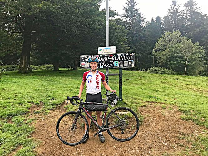
Col de Marie Blanque Bike Climb - PJAMM CyclingCol de Marie Blanque Bike Climb - PJAMM Cycling

15.2
PDI
5.7 mi
DISTANCE
2,286 ft
GAINED
7.7 %
AVG. GRADE

FULL CLIMB STATS

Page Contributor(s): Carl Hansen, Guernsey, UK

INTRO

The Col de Marie Blanque from Escot starts by meandering through several small villages at a fairly calm gradient. The fun really starts with about 4k to the top with 10%+ gradients for much of the remaining climb.

The climb has been featured 16 times in the Tour as of 2023.  Col de Marie Blanque has the steepest mile segment of any other climb of the 2023 TdF averaging 13.3% beginning at kilometer 6. 

PLAN YOUR ROUTE

We've partnered with Sherpa-Map.com to bring you the best route planning tool. With a PRO Membership you can use this climb as a reference when creating your route.

PROFILE CLICK IMAGE or BUTTON FOR INTERACTIVE TOOL

This climb averages 7.7%. The steepest quarter mile of this climb is 16.4% and steepest continuous mile is 13.3%. 1.4 miles of the climb is at or above 10% grade. The gradient on this climb is broken down as follows: 1.8 miles (31.5%) at 0-5% grade; 2.4 miles (43.4%) at 5-10% grade; 1 miles (18.1%) at 10-15% grade; 0.4 miles (7%) at 15-20% grade;

See more details and tools regarding this climb's grade via our interactive Profile Tool.
Roadway: The roadway is in good shape up to the col.

Traffic: There is very little traffic.

Parking: You can park near the bottom of the climb, or you can ride to the start of the climb from Arette, Aramits, and other nearby villages.

Summer in the Pyrenees is normally warm and sunny, even at higher elevations. However, there are some periods of low clouds that can make the climbs quite damp. Bring warm clothes just in case. Take food and water with you. There is a bike shop in Arette.  
Before heading out on any cycling adventure check out our Things to Bring on a Cycling Trip and use our interactive check list to ensure you don't forget anything.
There are places to stay in Arette, Aramits, and some of the smaller villages in the area. Arette and Aramits also have restaurants and shops for food. 

ROUTE MAP

MEMBER RATING

Difficulty: Strenuous
4
Road
4
Traffic
2
Scenery

CURRENT WEATHER

PJAMM TRIPS ADVENTURE STARTER BUNDLES

Check out PJAMM Adventure's prepackaged (self-guided) cycling trips. They will help you plan, document and conquer your next adventure.
ALL TRIPS
Browse all of our prepackaged trips and find your next adventure!

NEARBY CLIMBS (36) RADIAL PROXIMITY

FROM
Col de la Pierre St. Martin (D132)
1
28.3 PDI
France

404
32

11.6
4,369
7.1 %
Port de Larrau
2
28.1 PDI
France

410
35

9.1
3,954
8.1 %
Col de la Pierre St. Martin (D113)
3
27.6 PDI
France

422
38

14.9
4,786
6 %
Col d'Aubisque (Laruns)
4
24.2 PDI
France

-
84

10.5
3,817
6.9 %
Super Lescun
5
24 PDI
France

-
89

6.6
3,140
9 %
Col Issarbe
6
23.1 PDI
France

-
99

8.4
3,403
7.7 %
Col de Soudet
7
22.8 PDI
France

-
104

9.4
3,543
7.2 %
Col d'Aubisque (Ferrières)
8
22.6 PDI
France

-
108

13.4
4,154
5.3 %
Col du Pourtalet
9
20.6 PDI
France

-
160

17.6
4,252
4.5 %
Col du Soulor (Ferrières)
10
20.5 PDI
France

-
161

7.3
3,017
7.6 %
Col de Spandelles Ferrieres
11
19.9 PDI
France

-
176

6.4
2,789
8.3 %
Col du Somport
12
19.7 PDI
France

-
186

17
4,151
4.4 %
Col de Bagargi
13
18.8 PDI
France

-
206

5.9
2,614
8.3 %
Ahusquy (est)
14
16.6 PDI
France

-
267

8.6
2,916
6 %
Ahusquy (nord)
15
15.4 PDI
France

-
301

9.2
2,816
5.8 %
Col de la Pierre St. Martin (Spain)
16
14.2 PDI
Spain

-
133

8.7
2,585
5.5 %
Col du Soulor (Arrens)
17
13.6 PDI
France

-
371

4.7
1,943
7.9 %
Port de Larrau (Navarra)
18
13.5 PDI
Spain

-
140

6.7
2,247
6.4 %
Col de Bouesou (D441)
19
12 PDI
France

-
432

5.1
1,913
7 %
Col de Bouesou (D442)
20
11.3 PDI
France

-
458

6.2
2,015
6 %
Plateau de Lhers
21
11 PDI
France

-
468

4.6
1,738
7.1 %
Subida Gabardito
22
10.6 PDI
Spain

-
200

3.9
1,569
7.6 %
Col de Marie-Blanque (Bielle)
23
9.6 PDI
France

-
-

6.9
1,895
5.1 %
Lac d'Estaing
24
8.6 PDI
France

-
-

6.4
1,708
5 %
Collado de Argibiela
25
7.5 PDI
Spain

-
280

5.8
1,511
4.8 %
Col d'Ichere West
26
7.2 PDI
France

-
-

2.4
1,032
8.2 %
Col Heguichouria
27
5.9 PDI
France

-
-

3.6
1,079
5.5 %
Col des Bordères (ouest)
28
5.8 PDI
France

-
-

2.1
865
7.7 %
Matamachos (este)
29
5.7 PDI
Spain

-
343

3.2
1,008
6 %
Col d'Ichere
30
5 PDI
France

-
-

2.7
878
6.3 %
Alto Echo (Hecho)
31
4.5 PDI
Spain

-
380

2.8
822
5.7 %
Col des Bordères (est)
32
4 PDI
France

-
-

1.5
587
7.6 %
Côte de Notre-Dame de Piétat
33
2.6 PDI
France

-
-

1.6
477
5.7 %
Col de Burdincurutcheta (est)
34
2.1 PDI
France

-
-

1.4
403
5.4 %
La Crapere ouest
35
1.4 PDI
France

-
-

1.3
310
4.5 %
La Crapere est
36
0.9 PDI
France

-
-

0.9
196
4.3 %

MEMBER REVIEWS & COMMENTS

Let us know what you thought of this climb. Signup for our FREE membership to write a review or post a comment.
Already have an account?

Apr 5, 2021
difficulty: Strenuous
scenery: 2
traffic: 4
road: 4
Apr 5, 2021
scenery: 2
traffic: 4
road: 4
This climb is all about the last 3 to 4 kilometers, which are pretty much all double digits gradient. There is not much scenery and there is little activity in this part of the Pyrenees, but the climb is a good challenge.
ROUTE MAP
PROFILE TOOL

Col de Marie Blanque

STREET VIEWS
Explore the climbing route via Google Street Views.
IMAGES
View epic images taken along the climbing route.
SEGMENT
Select a portion of the route to retrieve climb & profile data for that segment.
GRADIENT
See where the steepest portions of the climb are located by gradient group.
Gradient
30%
20%
10%
0%
Route Data
S.G. (%)
hide

Steepest Gradient (%)

16.4
0.25 mi
14.7
0.5 mi
13.3
1 mi
11.3
2.5 mi
8.3
5 mi

Click on above gradient to display on profile.

Drag Knobs to Select Segment

Route Data
S.G. (%)
hide

Steepest Gradient (%)

16.4
0.25 mi
14.7
0.5 mi
13.3
1 mi
11.3
2.5 mi
8.3
5 mi

Click on above gradient to display on profile.

Segment Data
hide
CLIMB SUMMARY

Cycling Col de Marie Blanque from Escot (west)

Ride 9.2  kilometers gaining 711 meters at 7.7% average grade.

The route to Col de Marie Blanque from the west is the more popular route when the col is featured in the Tour de France. This is also the most difficult side to climb the col from, by far.

 Legend has it that the col’s name dates back to the mid eighteenth century and Marie Asserquet, a renowned pale (white/blanque) skinned aurostère (an author and performer of improvised chants memorializing the dead).  Friebe and Goding, Mountain Higher p. 46.  

The eastern approach to the col from Beille (population 528) is the easiest by far at 11.1 kilometers/5.1% versus from Escot at 9.2 kilometers/7.7%.

Climb start - Escot.

There is 1 hairpin on the climb, 300 meters from the finish.  

The 3.5 kilometers leading to the hairpin averages 11.7% while the last 300 meters is at 1% - a sprint to the finish.

Kilometer markers lead us up the climb.

Finish

TOUR DE FRANCE HISTORY OF COL DE MARIE BLANQUE

Stage 5 of the 2023 TdF was won by J. Hindley (UK)

Photo:  Letour.fr

The col first appeared in the Tour de France in 1978 when it dashed the repeat hopes of 1977 Tour champion Bernard Thevent.  Marie-Blanque was the major ascent of Stage 10 of the 1978 TdF and Thevenet was dropped on the climb and had lost 8 minutes by the summit and finished the stage nearly 13 minutes behind stage winner Henk Lubberding.  The two time Tour champion Thevenet retired from the race on Col du Tourmalet in Stage 11.

Col de Marie Blanque has been featured in the Tour de France 16 times as of 2023.  

Marie Blanque beat down Bradley Wiggins on Stage 17 of the 2010 Tour de France leading to Wiggins stating ““This is just the mountain I don’t cope with very easily and it seems to defy analysis.”  Wiggins lost 23 minutes on Andy Schleck that day, finishing 88th.
Access to full Climb Summary requires a PJAMM Cycling PRO Membership!

It takes less than a minute to sign up & with your PRO membership you can:
  • Rate climbs, post comments and share your experiences on any of our climb pages
  • Create bucket lists of climbs & mark the dates you complete them
  • Weather data for all climbs - Start & Finish
  • Upload photos to your member page to customize your PJAMM Cycling experience
  • Utilize all of our interactive tools - Profile & Routes in Area
  • Download climb route .gpx files

TRY PRO FREE FOR 7 DAYS

LEARN MORE
SIGN UP

Already have an account? LOG IN HERE

BESbswy